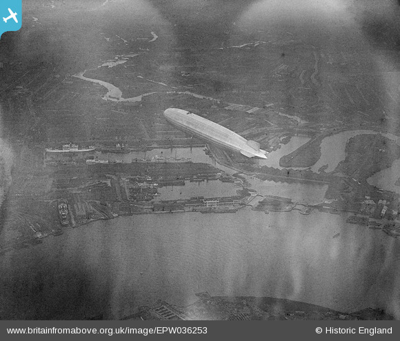
EPW036253 ENGLAND (1931). The D-LZ 127 Graf Zeppelin over the East India Docks and the River Thames, Blackwall, 1931
© Copyright OpenStreetMap contributors and licensed by the OpenStreetMap Foundation. 2024. Cartography is licensed as CC BY-SA.
Nearby Images (44)
Details
| Title | [EPW036253] The D-LZ 127 Graf Zeppelin over the East India Docks and the River Thames, Blackwall, 1931 |
| Reference | EPW036253 |
| Date | 18-August-1931 |
| Link | |
| Place name | BLACKWALL |
| Parish | |
| District | |
| Country | ENGLAND |
| Easting / Northing | 538866, 180994 |
| Longitude / Latitude | 0.0013184655274791, 51.510303950727 |
| National Grid Reference | TQ389810 |
Pins
Be the first to add a comment to this image!


![[EPW036253] The D-LZ 127 Graf Zeppelin over the East India Docks and the River Thames, Blackwall, 1931](http://britainfromabove.org.uk/sites/all/libraries/aerofilms-images/public/100x100/EPW/036/EPW036253.jpg)
![[EPW005311] East India Docks, Blackwall, 1921](http://britainfromabove.org.uk/sites/all/libraries/aerofilms-images/public/100x100/EPW/005/EPW005311.jpg)
![[EAW012154] East India Docks, Blackwall, 1947. This image was marked by Aerofilms Ltd for photo editing.](http://britainfromabove.org.uk/sites/all/libraries/aerofilms-images/public/100x100/EAW/012/EAW012154.jpg)
![[EAW008754] Brunswick Wharf Generating Station, East India Dock Basin and the River Lea, Blackwall, 1947. This image has been produced from a print.](http://britainfromabove.org.uk/sites/all/libraries/aerofilms-images/public/100x100/EAW/008/EAW008754.jpg)
![[EAW008752] Brunswick Wharf Generating Station and the East India Dock Basin, Blackwall, 1947. This image has been produced from a print.](http://britainfromabove.org.uk/sites/all/libraries/aerofilms-images/public/100x100/EAW/008/EAW008752.jpg)
![[EAW008749] The East India Docks, Blackwall, 1947](http://britainfromabove.org.uk/sites/all/libraries/aerofilms-images/public/100x100/EAW/008/EAW008749.jpg)
![[EAW013360] The East India Docks, Blackwall, 1948. This image was marked by Aerofilms Ltd for photo editing.](http://britainfromabove.org.uk/sites/all/libraries/aerofilms-images/public/100x100/EAW/013/EAW013360.jpg)
![[EAW013359] The East India Docks, Blackwall, 1948](http://britainfromabove.org.uk/sites/all/libraries/aerofilms-images/public/100x100/EAW/013/EAW013359.jpg)
![[EAW013365] The East India Docks, Blackwall, 1948. This image was marked by Aerofilms Ltd for photo editing.](http://britainfromabove.org.uk/sites/all/libraries/aerofilms-images/public/100x100/EAW/013/EAW013365.jpg)
![[EAW004329] The East India Dock and Dock Basin, Blackwall, 1947](http://britainfromabove.org.uk/sites/all/libraries/aerofilms-images/public/100x100/EAW/004/EAW004329.jpg)
![[EAW004332] The East India Docks, Blackwall, 1947](http://britainfromabove.org.uk/sites/all/libraries/aerofilms-images/public/100x100/EAW/004/EAW004332.jpg)
![[EAW004325] The East India Docks, Blackwall, 1947](http://britainfromabove.org.uk/sites/all/libraries/aerofilms-images/public/100x100/EAW/004/EAW004325.jpg)
![[EAW012152] East India Dock (Export) and Dock Basin, Blackwall, 1947. This image was marked by Aerofilms Ltd for photo editing.](http://britainfromabove.org.uk/sites/all/libraries/aerofilms-images/public/100x100/EAW/012/EAW012152.jpg)
![[EAW008751] The East India Docks, Blackwall, 1947. This image has been produced from a damaged negative.](http://britainfromabove.org.uk/sites/all/libraries/aerofilms-images/public/100x100/EAW/008/EAW008751.jpg)
![[EAW013630] The East India Docks, Blackwall, 1948. This image was marked by Aerofilms Ltd for photo editing.](http://britainfromabove.org.uk/sites/all/libraries/aerofilms-images/public/100x100/EAW/013/EAW013630.jpg)
![[EAW013634] Construction work for the Brunswick Wharf Power Station at the East India Export Dock, Blackwall, 1948. This image was marked by Aerofilms Ltd for photo editing.](http://britainfromabove.org.uk/sites/all/libraries/aerofilms-images/public/100x100/EAW/013/EAW013634.jpg)
![[EAW024921] Brunswick Wharf Generating Station under construction and East India (Import) Dock, Blackwall, 1949. This image was marked by Aerofilms Ltd for photo editing.](http://britainfromabove.org.uk/sites/all/libraries/aerofilms-images/public/100x100/EAW/024/EAW024921.jpg)
![[EAW013625] The East India Docks, Blackwall, 1948. This image was marked by Aerofilms Ltd for photo editing.](http://britainfromabove.org.uk/sites/all/libraries/aerofilms-images/public/100x100/EAW/013/EAW013625.jpg)
![[EPW009112] The East India Docks and environs, Blackwall, 1923. This image has been produced from a copy-negative.](http://britainfromabove.org.uk/sites/all/libraries/aerofilms-images/public/100x100/EPW/009/EPW009112.jpg)
![[EAW024916] Brunswick Wharf Generating Station under construction, Blackwall, 1949. This image was marked by Aerofilms Ltd for photo editing.](http://britainfromabove.org.uk/sites/all/libraries/aerofilms-images/public/100x100/EAW/024/EAW024916.jpg)
![[EAW024922] Brunswick Wharf Generating Station under construction and environs, Blackwall, 1949. This image was marked by Aerofilms Ltd for photo editing.](http://britainfromabove.org.uk/sites/all/libraries/aerofilms-images/public/100x100/EAW/024/EAW024922.jpg)
![[EPW011938] The East India Docks and environs, Blackwall, 1924. This image has been produced from a copy-negative.](http://britainfromabove.org.uk/sites/all/libraries/aerofilms-images/public/100x100/EPW/011/EPW011938.jpg)
![[EAW013364] The East India Docks, Blackwall, 1948. This image was marked by Aerofilms Ltd for photo editing.](http://britainfromabove.org.uk/sites/all/libraries/aerofilms-images/public/100x100/EAW/013/EAW013364.jpg)
![[EAW004328] The East India Dock and Dock Basin, Blackwall, 1947](http://britainfromabove.org.uk/sites/all/libraries/aerofilms-images/public/100x100/EAW/004/EAW004328.jpg)
![[EAW012153] East India Dock (Export) and Dock Basin, Blackwall, 1947. This image was marked by Aerofilms Ltd for photo editing.](http://britainfromabove.org.uk/sites/all/libraries/aerofilms-images/public/100x100/EAW/012/EAW012153.jpg)
![[EAW004330] The East India Docks, Blackwall, 1947](http://britainfromabove.org.uk/sites/all/libraries/aerofilms-images/public/100x100/EAW/004/EAW004330.jpg)
![[EAW013628] The East India Docks, Blackwall, 1948](http://britainfromabove.org.uk/sites/all/libraries/aerofilms-images/public/100x100/EAW/013/EAW013628.jpg)
![[EAW024919] Brunswick Wharf Generating Station under construction, Blackwall, 1949. This image was marked by Aerofilms Ltd for photo editing.](http://britainfromabove.org.uk/sites/all/libraries/aerofilms-images/public/100x100/EAW/024/EAW024919.jpg)
![[EAW013627] The East India Docks, Blackwall, 1948. This image was marked by Aerofilms Ltd for photo editing.](http://britainfromabove.org.uk/sites/all/libraries/aerofilms-images/public/100x100/EAW/013/EAW013627.jpg)
![[EAW013631] The East India Docks, Blackwall, 1948. This image was marked by Aerofilms Ltd for photo editing.](http://britainfromabove.org.uk/sites/all/libraries/aerofilms-images/public/100x100/EAW/013/EAW013631.jpg)
![[EAW013635] Construction work for the Brunswick Wharf Power Station at the East India Export Dock, Blackwall, 1948](http://britainfromabove.org.uk/sites/all/libraries/aerofilms-images/public/100x100/EAW/013/EAW013635.jpg)
![[EAW024918] Brunswick Wharf Generating Station under construction, Blackwall, 1949](http://britainfromabove.org.uk/sites/all/libraries/aerofilms-images/public/100x100/EAW/024/EAW024918.jpg)
![[EAW013629] The East India Docks, Blackwall, 1948. This image was marked by Aerofilms Ltd for photo editing.](http://britainfromabove.org.uk/sites/all/libraries/aerofilms-images/public/100x100/EAW/013/EAW013629.jpg)
![[EAW008750] The East India Docks, Blackwall, 1947](http://britainfromabove.org.uk/sites/all/libraries/aerofilms-images/public/100x100/EAW/008/EAW008750.jpg)
![[EAW024917] Brunswick Wharf Generating Station under construction, Blackwall, 1949. This image was marked by Aerofilms Ltd for photo editing.](http://britainfromabove.org.uk/sites/all/libraries/aerofilms-images/public/100x100/EAW/024/EAW024917.jpg)
![[EAW004327] The East India Dock, Blackwall, 1947](http://britainfromabove.org.uk/sites/all/libraries/aerofilms-images/public/100x100/EAW/004/EAW004327.jpg)
![[EAW024914] Brunswick Wharf Generating Station under construction and East India (Import) Dock, Blackwall, 1949](http://britainfromabove.org.uk/sites/all/libraries/aerofilms-images/public/100x100/EAW/024/EAW024914.jpg)
![[EAW013366] The East India Docks, Blackwall, 1948. This image was marked by Aerofilms Ltd for photo editing.](http://britainfromabove.org.uk/sites/all/libraries/aerofilms-images/public/100x100/EAW/013/EAW013366.jpg)
![[EAW024920] Brunswick Wharf Generating Station under construction and environs, Blackwall, 1949. This image was marked by Aerofilms Ltd for photo editing.](http://britainfromabove.org.uk/sites/all/libraries/aerofilms-images/public/100x100/EAW/024/EAW024920.jpg)
![[EAW013624] The East India Export Dock, Blackwall, 1948. This image was marked by Aerofilms Ltd for photo editing.](http://britainfromabove.org.uk/sites/all/libraries/aerofilms-images/public/100x100/EAW/013/EAW013624.jpg)
![[EAW053005] Brunswick Wharf (Blackwall) Power Station, East India Docks and environs, Blackwall, 1953](http://britainfromabove.org.uk/sites/all/libraries/aerofilms-images/public/100x100/EAW/053/EAW053005.jpg)
![[EAW013361] The East India Docks, Blackwall, from the north-east, 1948. This image was marked by Aerofilms Ltd for photo editing.](http://britainfromabove.org.uk/sites/all/libraries/aerofilms-images/public/100x100/EAW/013/EAW013361.jpg)
![[EAW013632] The East India Docks, Blackwall, from the south-east, 1948. This image was marked by Aerofilms Ltd for photo editing.](http://britainfromabove.org.uk/sites/all/libraries/aerofilms-images/public/100x100/EAW/013/EAW013632.jpg)
![[EAW035504] The Limmo Peninsula, Goodluck Hope/Leamouth Peninsula and environs, Canning Town, 1951. This image has been produced from a print.](http://britainfromabove.org.uk/sites/all/libraries/aerofilms-images/public/100x100/EAW/035/EAW035504.jpg)