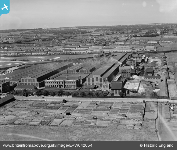
EPW042054 ENGLAND (1933). The National Radiator Company Works, Kingston Upon Hull, from the east, 1933
© Copyright OpenStreetMap contributors and licensed by the OpenStreetMap Foundation. 2024. Cartography is licensed as CC BY-SA.
Nearby Images (48)
Details
| Title | [EPW042054] The National Radiator Company Works, Kingston Upon Hull, from the east, 1933 |
| Reference | EPW042054 |
| Date | June-1933 |
| Link | |
| Place name | KINGSTON UPON HULL |
| Parish | |
| District | |
| Country | ENGLAND |
| Easting / Northing | 506743, 429903 |
| Longitude / Latitude | -0.38086394778543, 53.75432259902 |
| National Grid Reference | TA067299 |


![[EPW042054] The National Radiator Company Works, Kingston Upon Hull, from the east, 1933](http://britainfromabove.org.uk/sites/all/libraries/aerofilms-images/public/100x100/EPW/042/EPW042054.jpg)
![[EPW042050] The National Radiator Company Works, Kingston Upon Hull, from the east, 1933](http://britainfromabove.org.uk/sites/all/libraries/aerofilms-images/public/100x100/EPW/042/EPW042050.jpg)
![[EPW042051] The National Radiator Company Works, Kingston Upon Hull, from the east, 1933](http://britainfromabove.org.uk/sites/all/libraries/aerofilms-images/public/100x100/EPW/042/EPW042051.jpg)
![[EPW042792] Ideal Boilers and Radiators Ltd National Radiator Works, Kingston upon Hull, 1933](http://britainfromabove.org.uk/sites/all/libraries/aerofilms-images/public/100x100/EPW/042/EPW042792.jpg)
![[EPW042047] The National Radiator Company Works, Kingston Upon Hull, from the east, 1933](http://britainfromabove.org.uk/sites/all/libraries/aerofilms-images/public/100x100/EPW/042/EPW042047.jpg)
![[EPW042049] The National Radiator Company Works, Kingston Upon Hull, from the east, 1933](http://britainfromabove.org.uk/sites/all/libraries/aerofilms-images/public/100x100/EPW/042/EPW042049.jpg)
![[EPW042053] The National Radiator Company Works, Kingston Upon Hull, from the east, 1933](http://britainfromabove.org.uk/sites/all/libraries/aerofilms-images/public/100x100/EPW/042/EPW042053.jpg)
![[EPW010832] National Radiator Works, Kingston upon Hull, 1924](http://britainfromabove.org.uk/sites/all/libraries/aerofilms-images/public/100x100/EPW/010/EPW010832.jpg)
![[EPW042052] The National Radiator Company Works, Kingston Upon Hull, from the east, 1933](http://britainfromabove.org.uk/sites/all/libraries/aerofilms-images/public/100x100/EPW/042/EPW042052.jpg)
![[EPW042048] The National Radiator Company Works, Kingston Upon Hull, from the east, 1933](http://britainfromabove.org.uk/sites/all/libraries/aerofilms-images/public/100x100/EPW/042/EPW042048.jpg)
![[EPW031639] National Radiator Works, Kingston upon Hull, 1930](http://britainfromabove.org.uk/sites/all/libraries/aerofilms-images/public/100x100/EPW/031/EPW031639.jpg)
![[EPW031640] National Radiator Works, Kingston upon Hull, 1930](http://britainfromabove.org.uk/sites/all/libraries/aerofilms-images/public/100x100/EPW/031/EPW031640.jpg)
![[EPW031232] The National Radiator Works, Kingston upon Hull, 1930. This image was marked by Aerofilms Ltd for photo editing.](http://britainfromabove.org.uk/sites/all/libraries/aerofilms-images/public/100x100/EPW/031/EPW031232.jpg)
![[EPW031638] National Radiator Works, Kingston upon Hull, 1930](http://britainfromabove.org.uk/sites/all/libraries/aerofilms-images/public/100x100/EPW/031/EPW031638.jpg)
![[EPW031636] National Radiator Works, Kingston upon Hull, 1930](http://britainfromabove.org.uk/sites/all/libraries/aerofilms-images/public/100x100/EPW/031/EPW031636.jpg)
![[EPW031641] National Radiator Works, Kingston upon Hull, 1930](http://britainfromabove.org.uk/sites/all/libraries/aerofilms-images/public/100x100/EPW/031/EPW031641.jpg)
![[EPW031637] National Radiator Works, Kingston upon Hull, 1930](http://britainfromabove.org.uk/sites/all/libraries/aerofilms-images/public/100x100/EPW/031/EPW031637.jpg)
![[EAW046034] The Ideal Boiler and Radiator Works, Kingston upon Hull, from the east, 1952](http://britainfromabove.org.uk/sites/all/libraries/aerofilms-images/public/100x100/EAW/046/EAW046034.jpg)
![[EAW046038] The Ideal Boiler and Radiator Works, Kingston upon Hull, from the east, 1952. This image was marked by Aerofilms Ltd for photo editing.](http://britainfromabove.org.uk/sites/all/libraries/aerofilms-images/public/100x100/EAW/046/EAW046038.jpg)
![[EAW046030] The Ideal Boiler and Radiator Works, Kingston upon Hull, from the east, 1952. This image was marked by Aerofilms Ltd for photo editing.](http://britainfromabove.org.uk/sites/all/libraries/aerofilms-images/public/100x100/EAW/046/EAW046030.jpg)
![[EAW046033] The Ideal Boiler and Radiator Works, Kingston upon Hull, from the east, 1952. This image was marked by Aerofilms Ltd for photo editing.](http://britainfromabove.org.uk/sites/all/libraries/aerofilms-images/public/100x100/EAW/046/EAW046033.jpg)
![[EAW028589] The Ideal Boiler and Radiator Works, Kingston upon Hull, 1950. This image was marked by Aerofilms Ltd for photo editing.](http://britainfromabove.org.uk/sites/all/libraries/aerofilms-images/public/100x100/EAW/028/EAW028589.jpg)
![[EPW042793] Ideal Boilers and Radiators Ltd National Radiator Works, Kingston upon Hull, 1933](http://britainfromabove.org.uk/sites/all/libraries/aerofilms-images/public/100x100/EPW/042/EPW042793.jpg)
![[EAW046035] The Ideal Boiler and Radiator Works, Kingston upon Hull, from the south-east, 1952. This image was marked by Aerofilms Ltd for photo editing.](http://britainfromabove.org.uk/sites/all/libraries/aerofilms-images/public/100x100/EAW/046/EAW046035.jpg)
![[EPW012815] National Radiator Works, Kingston upon Hull, 1925](http://britainfromabove.org.uk/sites/all/libraries/aerofilms-images/public/100x100/EPW/012/EPW012815.jpg)
![[EPW042794] Ideal Boilers and Radiators Ltd National Radiator Works, Kingston upon Hull, 1933](http://britainfromabove.org.uk/sites/all/libraries/aerofilms-images/public/100x100/EPW/042/EPW042794.jpg)
![[EAW046036] The Ideal Boiler and Radiator Works, Kingston upon Hull, from the south-east, 1952. This image was marked by Aerofilms Ltd for photo editing.](http://britainfromabove.org.uk/sites/all/libraries/aerofilms-images/public/100x100/EAW/046/EAW046036.jpg)
![[EPW042791] Ideal Boilers and Radiators Ltd National Radiator Works, Kingston upon Hull, 1933](http://britainfromabove.org.uk/sites/all/libraries/aerofilms-images/public/100x100/EPW/042/EPW042791.jpg)
![[EPW042790] Ideal Boilers and Radiators Ltd National Radiator Works, Kingston upon Hull, 1933](http://britainfromabove.org.uk/sites/all/libraries/aerofilms-images/public/100x100/EPW/042/EPW042790.jpg)
![[EPW042789] Ideal Boilers and Radiators Ltd National Radiator Works, Kingston upon Hull, 1933](http://britainfromabove.org.uk/sites/all/libraries/aerofilms-images/public/100x100/EPW/042/EPW042789.jpg)
![[EPW031230] The National Radiator Works, Kingston upon Hull, 1930. This image was marked by Aerofilms Ltd for photo editing.](http://britainfromabove.org.uk/sites/all/libraries/aerofilms-images/public/100x100/EPW/031/EPW031230.jpg)
![[EAW046037] The Ideal Boiler and Radiator Works, Kingston upon Hull, from the east, 1952. This image was marked by Aerofilms Ltd for photo editing.](http://britainfromabove.org.uk/sites/all/libraries/aerofilms-images/public/100x100/EAW/046/EAW046037.jpg)
![[EAW028585] The Ideal Boiler and Radiator Works and environs, Kingston upon Hull, 1950. This image was marked by Aerofilms Ltd for photo editing.](http://britainfromabove.org.uk/sites/all/libraries/aerofilms-images/public/100x100/EAW/028/EAW028585.jpg)
![[EPW052224] Ideal Boilers and Radiators Ltd National Radiator Works, Kingston upon Hull, 1936. This image has been produced from a damaged negative.](http://britainfromabove.org.uk/sites/all/libraries/aerofilms-images/public/100x100/EPW/052/EPW052224.jpg)
![[EPW052228] Ideal Boilers and Radiators Ltd National Radiator Works, Kingston upon Hull, 1936](http://britainfromabove.org.uk/sites/all/libraries/aerofilms-images/public/100x100/EPW/052/EPW052228.jpg)
![[EPW052230] Ideal Boilers and Radiators Ltd National Radiator Works, Kingston upon Hull, 1936](http://britainfromabove.org.uk/sites/all/libraries/aerofilms-images/public/100x100/EPW/052/EPW052230.jpg)
![[EPW052227] Ideal Boilers and Radiators Ltd National Radiator Works, Kingston upon Hull, 1936](http://britainfromabove.org.uk/sites/all/libraries/aerofilms-images/public/100x100/EPW/052/EPW052227.jpg)
![[EAW028591] The Ideal Boiler and Radiator Works and environs, Kingston upon Hull, 1950. This image was marked by Aerofilms Ltd for photo editing.](http://britainfromabove.org.uk/sites/all/libraries/aerofilms-images/public/100x100/EAW/028/EAW028591.jpg)
![[EPW052231] Ideal Boilers and Radiators Ltd National Radiator Works, Kingston upon Hull, 1936. This image has been produced from a damaged negative.](http://britainfromabove.org.uk/sites/all/libraries/aerofilms-images/public/100x100/EPW/052/EPW052231.jpg)
![[EAW046032] The Ideal Boiler and Radiator Works, Kingston upon Hull, from the south-east, 1952. This image was marked by Aerofilms Ltd for photo editing.](http://britainfromabove.org.uk/sites/all/libraries/aerofilms-images/public/100x100/EAW/046/EAW046032.jpg)
![[EAW028592] The Ideal Boiler and Radiator Works and environs, Kingston upon Hull, 1950. This image was marked by Aerofilms Ltd for photo editing.](http://britainfromabove.org.uk/sites/all/libraries/aerofilms-images/public/100x100/EAW/028/EAW028592.jpg)
![[EAW046031] The Ideal Boiler and Radiator Works, Kingston upon Hull, from the south-east, 1952](http://britainfromabove.org.uk/sites/all/libraries/aerofilms-images/public/100x100/EAW/046/EAW046031.jpg)
![[EPW052225] Ideal Boilers and Radiators Ltd National Radiator Works, Kingston upon Hull, 1936. This image has been produced from a damaged negative.](http://britainfromabove.org.uk/sites/all/libraries/aerofilms-images/public/100x100/EPW/052/EPW052225.jpg)
![[EPW052226] Ideal Boilers and Radiators Ltd National Radiator Works, Kingston upon Hull, 1936. This image has been produced from a damaged negative.](http://britainfromabove.org.uk/sites/all/libraries/aerofilms-images/public/100x100/EPW/052/EPW052226.jpg)
![[EPW052229] Ideal Boilers and Radiators Ltd National Radiator Works, Kingston upon Hull, 1936](http://britainfromabove.org.uk/sites/all/libraries/aerofilms-images/public/100x100/EPW/052/EPW052229.jpg)
![[EAW028584] The Ideal Boiler and Radiator Works and environs, Kingston upon Hull, 1950. This image was marked by Aerofilms Ltd for photo editing.](http://britainfromabove.org.uk/sites/all/libraries/aerofilms-images/public/100x100/EAW/028/EAW028584.jpg)
![[EAW046040] The Ideal Boiler and Radiator Works, Kingston upon Hull, from the south-east, 1952. This image was marked by Aerofilms Ltd for photo editing.](http://britainfromabove.org.uk/sites/all/libraries/aerofilms-images/public/100x100/EAW/046/EAW046040.jpg)
![[EAW028586] The Ideal Boiler and Radiator Works and environs, Kingston upon Hull, 1950. This image was marked by Aerofilms Ltd for photo editing.](http://britainfromabove.org.uk/sites/all/libraries/aerofilms-images/public/100x100/EAW/028/EAW028586.jpg)
