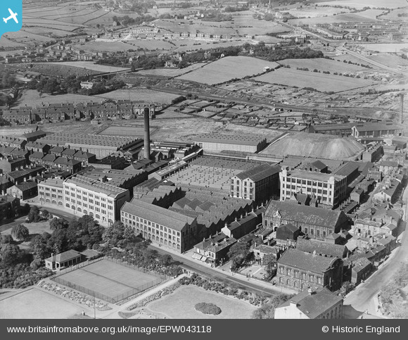
EPW043118 ENGLAND (1933). Flush Mills J.F. Firth and Son, Heckmondwike, 1933
© Copyright OpenStreetMap contributors and licensed by the OpenStreetMap Foundation. 2024. Cartography is licensed as CC BY-SA.
Nearby Images (7)
Details
| Title | [EPW043118] Flush Mills J.F. Firth and Son, Heckmondwike, 1933 |
| Reference | EPW043118 |
| Date | September-1933 |
| Link | |
| Place name | HECKMONDWIKE |
| Parish | |
| District | |
| Country | ENGLAND |
| Easting / Northing | 421200, 423700 |
| Longitude / Latitude | -1.6787843386319, 53.709067963807 |
| National Grid Reference | SE212237 |
Pins
 AdC |
Wednesday 3rd of July 2019 09:51:16 PM | |
 AdC |
Wednesday 3rd of July 2019 09:50:32 PM | |
 AdC |
Wednesday 3rd of July 2019 09:50:08 PM | |
 HOLMES |
Tuesday 14th of February 2017 12:02:40 PM | |
 Pat |
Sunday 6th of September 2015 10:35:24 PM |


![[EPW043118] Flush Mills J.F. Firth and Son, Heckmondwike, 1933](http://britainfromabove.org.uk/sites/all/libraries/aerofilms-images/public/100x100/EPW/043/EPW043118.jpg)
![[EPW043119] Flush Mills J.F. Firth and Son, Heckmondwike, 1933](http://britainfromabove.org.uk/sites/all/libraries/aerofilms-images/public/100x100/EPW/043/EPW043119.jpg)
![[EPW043120] Flush Mills J.F. Firth and Son, Heckmondwike, 1933](http://britainfromabove.org.uk/sites/all/libraries/aerofilms-images/public/100x100/EPW/043/EPW043120.jpg)
![[EPW043121] Flush Mills J.F. Firth and Son, Heckmondwike, 1933](http://britainfromabove.org.uk/sites/all/libraries/aerofilms-images/public/100x100/EPW/043/EPW043121.jpg)
![[EPW023795] Heckmondwike Woollen Flush Mills, Heckmondwike, 1928](http://britainfromabove.org.uk/sites/all/libraries/aerofilms-images/public/100x100/EPW/023/EPW023795.jpg)
![[EPW043122] Flush Mills J. F. Firth and Son, Heckmondwike, 1933](http://britainfromabove.org.uk/sites/all/libraries/aerofilms-images/public/100x100/EPW/043/EPW043122.jpg)
![[EPW023799] The town centre, Heckmondwike, 1928](http://britainfromabove.org.uk/sites/all/libraries/aerofilms-images/public/100x100/EPW/023/EPW023799.jpg)