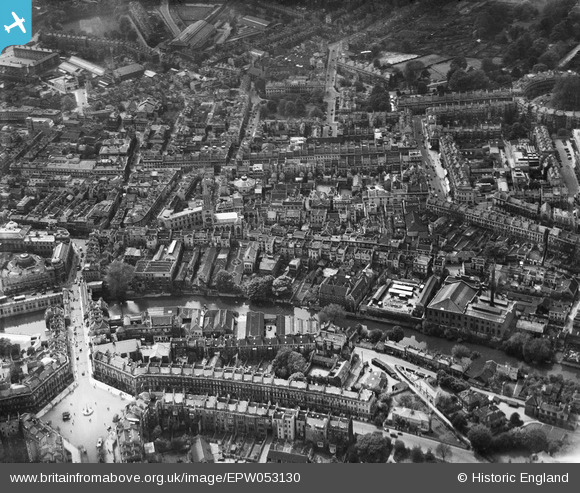
EPW053130 ENGLAND (1937). The city centre, Bath, 1937
© Copyright OpenStreetMap contributors and licensed by the OpenStreetMap Foundation. 2024. Cartography is licensed as CC BY-SA.
Nearby Images (20)
Details
| Title | [EPW053130] The city centre, Bath, 1937 |
| Reference | EPW053130 |
| Date | 19-May-1937 |
| Link | |
| Place name | BATH |
| Parish | |
| District | |
| Country | ENGLAND |
| Easting / Northing | 375057, 165075 |
| Longitude / Latitude | -2.3584664568632, 51.383676458953 |
| National Grid Reference | ST751651 |
Pins
 Class31 |
Wednesday 16th of July 2014 08:38:32 AM | |
 Class31 |
Wednesday 21st of August 2013 11:56:40 AM | |
 Class31 |
Wednesday 21st of August 2013 11:56:06 AM | |
 Class31 |
Wednesday 21st of August 2013 11:55:37 AM | |
 Class31 |
Wednesday 21st of August 2013 11:54:58 AM | |
 Class31 |
Wednesday 21st of August 2013 11:54:20 AM | |
 Class31 |
Wednesday 21st of August 2013 11:53:53 AM | |
 Class31 |
Wednesday 21st of August 2013 11:52:38 AM | |
 Class31 |
Wednesday 21st of August 2013 11:50:38 AM | |
 Class31 |
Wednesday 21st of August 2013 11:42:25 AM | |
 Class31 |
Wednesday 21st of August 2013 11:39:27 AM | |
 Class31 |
Wednesday 21st of August 2013 11:34:12 AM | |
 Class31 |
Wednesday 21st of August 2013 11:32:46 AM | |
 Class31 |
Wednesday 21st of August 2013 11:32:27 AM | |
 Class31 |
Wednesday 21st of August 2013 11:31:45 AM | |
 Class31 |
Wednesday 21st of August 2013 11:31:09 AM |


![[EPW053130] The city centre, Bath, 1937](http://britainfromabove.org.uk/sites/all/libraries/aerofilms-images/public/100x100/EPW/053/EPW053130.jpg)
![[EPW053127] Pulteney Bridge, St Michael's Church and The Circus, Bath, 1937](http://britainfromabove.org.uk/sites/all/libraries/aerofilms-images/public/100x100/EPW/053/EPW053127.jpg)
![[EPW053133] The city centre, Bath, 1937](http://britainfromabove.org.uk/sites/all/libraries/aerofilms-images/public/100x100/EPW/053/EPW053133.jpg)
![[EPW053138] The city centre, Bath, 1937](http://britainfromabove.org.uk/sites/all/libraries/aerofilms-images/public/100x100/EPW/053/EPW053138.jpg)
![[EPW053134] The city centre, Bath, 1937](http://britainfromabove.org.uk/sites/all/libraries/aerofilms-images/public/100x100/EPW/053/EPW053134.jpg)
![[EPW053128] Pulteney Bridge, St Michael's Church and environs, Bath, 1937](http://britainfromabove.org.uk/sites/all/libraries/aerofilms-images/public/100x100/EPW/053/EPW053128.jpg)
![[EPW001958] General view of the town centre, Bath, from the north, 1920](http://britainfromabove.org.uk/sites/all/libraries/aerofilms-images/public/100x100/EPW/001/EPW001958.jpg)
![[EPW053129] The Tramway Depot, the Cattle Market and Laura Place, Bath, 1937](http://britainfromabove.org.uk/sites/all/libraries/aerofilms-images/public/100x100/EPW/053/EPW053129.jpg)
![[EPW053131] The Tramway Depot, St Michael's Church and Laura Place, Bath, 1937](http://britainfromabove.org.uk/sites/all/libraries/aerofilms-images/public/100x100/EPW/053/EPW053131.jpg)
![[EPW053136] The city centre, Bath, 1937](http://britainfromabove.org.uk/sites/all/libraries/aerofilms-images/public/100x100/EPW/053/EPW053136.jpg)
![[EPW053135] Henrietta Park and the city centre, Bath, 1937. This image has been affected by flare.](http://britainfromabove.org.uk/sites/all/libraries/aerofilms-images/public/100x100/EPW/053/EPW053135.jpg)
![[EPW053132] Henrietta Park and the city centre, Bath, 1937](http://britainfromabove.org.uk/sites/all/libraries/aerofilms-images/public/100x100/EPW/053/EPW053132.jpg)
![[EPR000133] The Circus and the city centre, Bath, 1934](http://britainfromabove.org.uk/sites/all/libraries/aerofilms-images/public/100x100/EPR/000/EPR000133.jpg)
![[EAW000761] The city, Bath, 1946](http://britainfromabove.org.uk/sites/all/libraries/aerofilms-images/public/100x100/EAW/000/EAW000761.jpg)
![[EPW053137] The Circus and Henrietta Park, Bath, 1937](http://britainfromabove.org.uk/sites/all/libraries/aerofilms-images/public/100x100/EPW/053/EPW053137.jpg)
![[EPW048393] Gay Street and environs, Bath, from the south-east, 1935](http://britainfromabove.org.uk/sites/all/libraries/aerofilms-images/public/100x100/EPW/048/EPW048393.jpg)
![[EPW033154] The city, Bath, from the south-west, 1930](http://britainfromabove.org.uk/sites/all/libraries/aerofilms-images/public/100x100/EPW/033/EPW033154.jpg)
![[EPW053141] The Abbey Church of St Peter and St Paul, the Roman Baths and the city centre, Bath, 1937](http://britainfromabove.org.uk/sites/all/libraries/aerofilms-images/public/100x100/EPW/053/EPW053141.jpg)
![[EPR000129] Queen Square and the city centre, Bath, 1934](http://britainfromabove.org.uk/sites/all/libraries/aerofilms-images/public/100x100/EPR/000/EPR000129.jpg)
![[EPW001950] The Weir and Parade Gardens, Bath, 1920](http://britainfromabove.org.uk/sites/all/libraries/aerofilms-images/public/100x100/EPW/001/EPW001950.jpg)

