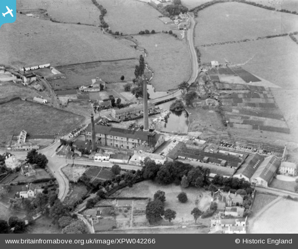
XPW042266 IRELAND (1933). Clondalkin Paper Mills, Clondalkin, Dublin, Ireland, 1933. Oblique aerial photograph taken facing East.
© Copyright OpenStreetMap contributors and licensed by the OpenStreetMap Foundation. 2024. Cartography is licensed as CC BY-SA.
Nearby Images (10)
Details
| Title | [XPW042266] Clondalkin Paper Mills, Clondalkin, Dublin, Ireland, 1933. Oblique aerial photograph taken facing East. |
| Reference | XPW042266 |
| Date | 1933 |
| Link | |
| Place name | CLONDALKIN |
| Parish | IRELAND |
| District | |
| Country | IRELAND |
| Easting / Northing | 107320, 389723 |
| Longitude / Latitude | -6.396622, 53.323284 |
| National Grid Reference |
Pins
 Patrick Ging |
Thursday 12th of August 2021 08:55:40 PM |


![[XPW042266] Clondalkin Paper Mills, Clondalkin, Dublin, Ireland, 1933. Oblique aerial photograph taken facing East.](http://britainfromabove.org.uk/sites/all/libraries/aerofilms-images/public/100x100/XPW/042/XPW042266.jpg)
![[XPW042268] Clondalkin Paper Mills, Clondalkin, Dublin, Ireland, 1933. Oblique aerial photograph taken facing East.](http://britainfromabove.org.uk/sites/all/libraries/aerofilms-images/public/100x100/XPW/042/XPW042268.jpg)
![[XPW042269] Clondalkin Paper Mills, Clondalkin, Dublin, Ireland, 1933. Oblique aerial photograph taken facing South.](http://britainfromabove.org.uk/sites/all/libraries/aerofilms-images/public/100x100/XPW/042/XPW042269.jpg)
![[XPW042272] Clondalkin Paper Mills, Clondalkin, Dublin, Ireland, 1933. Oblique aerial photograph taken facing North.](http://britainfromabove.org.uk/sites/all/libraries/aerofilms-images/public/100x100/XPW/042/XPW042272.jpg)
![[XPW042273] Clondalkin Paper Mills, Clondalkin, Dublin, Ireland, 1933. Oblique aerial photograph taken facing North/East.](http://britainfromabove.org.uk/sites/all/libraries/aerofilms-images/public/100x100/XPW/042/XPW042273.jpg)
![[XPW042271] Clondalkin Paper Mills, Clondalkin, Dublin, Ireland, 1933. Oblique aerial photograph taken facing North.](http://britainfromabove.org.uk/sites/all/libraries/aerofilms-images/public/100x100/XPW/042/XPW042271.jpg)
![[XPW042274] Clondalkin Paper Mills, Clondalkin, Dublin, Ireland, 1933. Oblique aerial photograph taken facing South.](http://britainfromabove.org.uk/sites/all/libraries/aerofilms-images/public/100x100/XPW/042/XPW042274.jpg)
![[XPW042267] Clondalkin Paper Mills, Clondalkin, Dublin, Ireland, 1933. Oblique aerial photograph taken facing North.](http://britainfromabove.org.uk/sites/all/libraries/aerofilms-images/public/100x100/XPW/042/XPW042267.jpg)
![[XPW042265] Clondalkin Paper Mills, Clondalkin, Dublin, Ireland, 1933. Oblique aerial photograph taken facing South/East.](http://britainfromabove.org.uk/sites/all/libraries/aerofilms-images/public/100x100/XPW/042/XPW042265.jpg)
![[XPW042270] Clondalkin Paper Mills, Clondalkin, Dublin, Ireland, 1933. Oblique aerial photograph taken facing East.](http://britainfromabove.org.uk/sites/all/libraries/aerofilms-images/public/100x100/XPW/042/XPW042270.jpg)