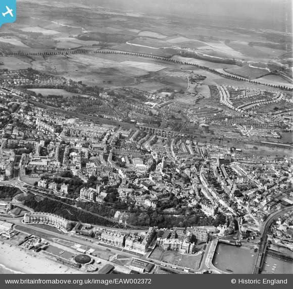
EAW002372 ENGLAND (1946). The town and Foord Viaduct, Folkestone, from the south-east, 1946
© Hawlfraint cyfranwyr OpenStreetMap a thrwyddedwyd gan yr OpenStreetMap Foundation. 2025. Trwyddedir y gartograffeg fel CC BY-SA.
Delweddau cyfagos (16)
Manylion
| Pennawd | [EAW002372] The town and Foord Viaduct, Folkestone, from the south-east, 1946 |
| Cyfeirnod | EAW002372 |
| Dyddiad | 9-September-1946 |
| Dolen | |
| Enw lle | FOLKESTONE |
| Plwyf | FOLKESTONE |
| Ardal | |
| Gwlad | ENGLAND |
| Dwyreiniad / Gogleddiad | 623049, 135873 |
| Hydred / Lledred | 1.1847194026765, 51.078222151482 |
| Cyfeirnod Grid Cenedlaethol | TR230359 |
Pinnau
 Kizle7 |
Friday 25th of August 2023 03:34:47 AM | |
 Sparky |
Sunday 17th of September 2017 04:34:15 PM | |
 Paolo |
Thursday 20th of August 2015 09:33:59 PM |


![[EAW002372] The town and Foord Viaduct, Folkestone, from the south-east, 1946](http://britainfromabove.org.uk/sites/all/libraries/aerofilms-images/public/100x100/EAW/002/EAW002372.jpg)
![[EPW009196] The Marine Crescent and Marine Parade, Folkestone, 1923](http://britainfromabove.org.uk/sites/all/libraries/aerofilms-images/public/100x100/EPW/009/EPW009196.jpg)
![[EPW035417] Victoria Pier, Marine Crescent and the town, Folkestone, 1931](http://britainfromabove.org.uk/sites/all/libraries/aerofilms-images/public/100x100/EPW/035/EPW035417.jpg)
![[EAW002852] The Marine Gardens, Marine Crescent and the town, Folkestone, from the south-east, 1946](http://britainfromabove.org.uk/sites/all/libraries/aerofilms-images/public/100x100/EAW/002/EAW002852.jpg)
![[EAW002373] The town, Folkestone, from the south-east, 1946](http://britainfromabove.org.uk/sites/all/libraries/aerofilms-images/public/100x100/EAW/002/EAW002373.jpg)
![[EPW000355] Folkestone, Kent, 1920](http://britainfromabove.org.uk/sites/all/libraries/aerofilms-images/public/100x100/EPW/000/EPW000355.jpg)
![[EAW024832] Marine Gardens and Marine Parade, Folkestone, 1949](http://britainfromabove.org.uk/sites/all/libraries/aerofilms-images/public/100x100/EAW/024/EAW024832.jpg)
![[EPW000083] Marine Parade, Folkestone, 1920](http://britainfromabove.org.uk/sites/all/libraries/aerofilms-images/public/100x100/EPW/000/EPW000083.jpg)
![[EPW019065] The Inner Harbour, Royal Pavilion Hotel and environs, Folkestone, 1927](http://britainfromabove.org.uk/sites/all/libraries/aerofilms-images/public/100x100/EPW/019/EPW019065.jpg)
![[EAW002853] The Folkestone Harbour Railway Station, the Royal Pavilion Hotel and the town, Folkestone, from the south-east, 1946](http://britainfromabove.org.uk/sites/all/libraries/aerofilms-images/public/100x100/EAW/002/EAW002853.jpg)
![[EPW042870] The Victoria Pier and Marine Parade, Folkestone, 1933](http://britainfromabove.org.uk/sites/all/libraries/aerofilms-images/public/100x100/EPW/042/EPW042870.jpg)
![[EPW000587] Marine Crescent and the harbour, Folkestone, from the south-west, 1920](http://britainfromabove.org.uk/sites/all/libraries/aerofilms-images/public/100x100/EPW/000/EPW000587.jpg)
![[EPW000372] Inner Harbour and Outer Harbour, Folkestone, 1920](http://britainfromabove.org.uk/sites/all/libraries/aerofilms-images/public/100x100/EPW/000/EPW000372.jpg)
![[EAW002851] The Marine Gardens, Marine Crescent and the surrounding residential area, Folkestone, from the south-east, 1946](http://britainfromabove.org.uk/sites/all/libraries/aerofilms-images/public/100x100/EAW/002/EAW002851.jpg)
![[EPW019064] Marine Crescent and the sea front, Folkestone, 1927. This image has been produced from a print.](http://britainfromabove.org.uk/sites/all/libraries/aerofilms-images/public/100x100/EPW/019/EPW019064.jpg)
![[EPW000080] Folkestone Lido, Folkestone, 1920](http://britainfromabove.org.uk/sites/all/libraries/aerofilms-images/public/100x100/EPW/000/EPW000080.jpg)