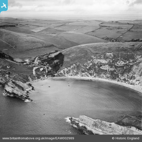
EAW002989 ENGLAND (1946). Wave diffraction, Lulworth Cove, from the south-east, 1946
© Hawlfraint cyfranwyr OpenStreetMap a thrwyddedwyd gan yr OpenStreetMap Foundation. 2025. Trwyddedir y gartograffeg fel CC BY-SA.
Delweddau cyfagos (9)
Manylion
| Pennawd | [EAW002989] Wave diffraction, Lulworth Cove, from the south-east, 1946 |
| Cyfeirnod | EAW002989 |
| Dyddiad | 3-October-1946 |
| Dolen | |
| Enw lle | LULWORTH COVE |
| Plwyf | WEST LULWORTH |
| Ardal | |
| Gwlad | ENGLAND |
| Dwyreiniad / Gogleddiad | 382564, 79917 |
| Hydred / Lledred | -2.2464897755498, 50.618114665186 |
| Cyfeirnod Grid Cenedlaethol | SY826799 |
Pinnau
 Matt Aldred edob.mattaldred.com |
Thursday 12th of November 2020 08:55:33 PM | |
 Matt Aldred edob.mattaldred.com |
Thursday 12th of November 2020 08:54:56 PM | |
 Matt Aldred edob.mattaldred.com |
Thursday 12th of November 2020 08:54:41 PM | |
 cptpies |
Wednesday 15th of January 2014 03:55:21 PM | |
 Al |
Monday 6th of January 2014 01:16:55 AM | |
 Al |
Monday 6th of January 2014 01:13:46 AM | |
 Al |
Monday 6th of January 2014 01:13:15 AM |
Cyfraniadau Grŵp
 cptpies |
Wednesday 15th of January 2014 03:58:39 PM |


![[EAW002989] Wave diffraction, Lulworth Cove, from the south-east, 1946](http://britainfromabove.org.uk/sites/all/libraries/aerofilms-images/public/100x100/EAW/002/EAW002989.jpg)
![[EPW013650] Lulworth Cove, West Lulworth, 1925. This image has been produced from a print.](http://britainfromabove.org.uk/sites/all/libraries/aerofilms-images/public/100x100/EPW/013/EPW013650.jpg)
![[EPW013653] Lulworth Cove, West Lulworth, 1925. This image has been produced from a copy-negative.](http://britainfromabove.org.uk/sites/all/libraries/aerofilms-images/public/100x100/EPW/013/EPW013653.jpg)
![[EAW049040] Lulworth Cove and the village, West Lulworth, 1953](http://britainfromabove.org.uk/sites/all/libraries/aerofilms-images/public/100x100/EAW/049/EAW049040.jpg)
![[EAW049041] Lulworth Cove, the village and the surrounding countryside, West Lulworth, from the south, 1953](http://britainfromabove.org.uk/sites/all/libraries/aerofilms-images/public/100x100/EAW/049/EAW049041.jpg)
![[EAW035600] Lulworth Cove, West Lulworth, 1951. This image has been produced from a print.](http://britainfromabove.org.uk/sites/all/libraries/aerofilms-images/public/100x100/EAW/035/EAW035600.jpg)
![[EAW035599] Lulworth Cove, West Lulworth, 1951. This image has been produced from a print.](http://britainfromabove.org.uk/sites/all/libraries/aerofilms-images/public/100x100/EAW/035/EAW035599.jpg)
![[EPW013652] Lulworth Cove, West Lulworth, 1925. This image has been produced from a copy-negative.](http://britainfromabove.org.uk/sites/all/libraries/aerofilms-images/public/100x100/EPW/013/EPW013652.jpg)
![[EAW049039] West Point, Stair Hole and the village, West Lulworth, from the south, 1953](http://britainfromabove.org.uk/sites/all/libraries/aerofilms-images/public/100x100/EAW/049/EAW049039.jpg)
