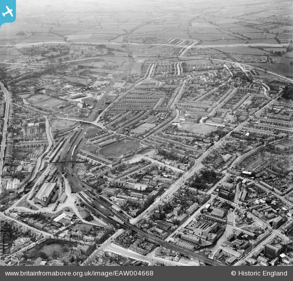
EAW004668 ENGLAND (1947). Friargate and environs, Derby, from the east, 1947
© Hawlfraint cyfranwyr OpenStreetMap a thrwyddedwyd gan yr OpenStreetMap Foundation. 2025. Trwyddedir y gartograffeg fel CC BY-SA.
Delweddau cyfagos (6)
Manylion
| Pennawd | [EAW004668] Friargate and environs, Derby, from the east, 1947 |
| Cyfeirnod | EAW004668 |
| Dyddiad | 22-April-1947 |
| Dolen | |
| Enw lle | DERBY |
| Plwyf | |
| Ardal | |
| Gwlad | ENGLAND |
| Dwyreiniad / Gogleddiad | 434564, 336455 |
| Hydred / Lledred | -1.4858178865098, 52.924076414643 |
| Cyfeirnod Grid Cenedlaethol | SK346365 |
Pinnau
 redmist |
Wednesday 25th of October 2023 09:10:11 PM | |
 HelsyB |
Saturday 10th of April 2021 04:18:37 AM | |
 HelsyB |
Saturday 10th of April 2021 04:16:49 AM | |
 almoffat |
Tuesday 11th of March 2014 10:04:00 PM | |
 almoffat |
Tuesday 11th of March 2014 10:01:25 PM | |
 almoffat |
Tuesday 11th of March 2014 09:59:31 PM | |
 almoffat |
Tuesday 11th of March 2014 09:58:11 PM | |
 almoffat |
Tuesday 11th of March 2014 09:53:57 PM | |
 almoffat |
Tuesday 11th of March 2014 09:52:50 PM | |
 almoffat |
Tuesday 11th of March 2014 09:51:31 PM | |
 almoffat |
Tuesday 11th of March 2014 09:49:53 PM |


![[EAW004668] Friargate and environs, Derby, from the east, 1947](http://britainfromabove.org.uk/sites/all/libraries/aerofilms-images/public/100x100/EAW/004/EAW004668.jpg)
![[EAW004671] Friargate and environs, Derby, from the east, 1947](http://britainfromabove.org.uk/sites/all/libraries/aerofilms-images/public/100x100/EAW/004/EAW004671.jpg)
![[EAW004667] Friar Gate and environs, Derby, from the north-east, 1947. This image was marked by Aerofilms Ltd for photo editing.](http://britainfromabove.org.uk/sites/all/libraries/aerofilms-images/public/100x100/EAW/004/EAW004667.jpg)
![[EAW004670] Friargate and environs, Derby, from the east, 1947](http://britainfromabove.org.uk/sites/all/libraries/aerofilms-images/public/100x100/EAW/004/EAW004670.jpg)
![[EAW044086] Friar Gate, the railway viaduct and environs, Derby, 1952](http://britainfromabove.org.uk/sites/all/libraries/aerofilms-images/public/100x100/EAW/044/EAW044086.jpg)
![[EAW044085] The Greyhound Stadium, Goods Depot and environs, Derby, 1952](http://britainfromabove.org.uk/sites/all/libraries/aerofilms-images/public/100x100/EAW/044/EAW044085.jpg)