
EAW005072 ENGLAND (1947). The seafront and town, Great Yarmouth, from the north-east, 1947

© Hawlfraint cyfranwyr OpenStreetMap a thrwyddedwyd gan yr OpenStreetMap Foundation. 2025. Trwyddedir y gartograffeg fel CC BY-SA.
Delweddau cyfagos (15)
EAW005072

EAW045612

EPW021186

EAW005071

EPW021196

EAW045607

EAW045611

EAW026623

EAW045614

EAW026624

EAW045609

EAW045610

EAW045613

EAW045606

EAW045608

Manylion
| Pennawd | [EAW005072] The seafront and town, Great Yarmouth, from the north-east, 1947 |
| Cyfeirnod | EAW005072 |
| Dyddiad | 11-May-1947 |
| Dolen | |
| Enw lle | GREAT YARMOUTH |
| Plwyf | |
| Ardal | |
| Gwlad | ENGLAND |
| Dwyreiniad / Gogleddiad | 653242, 307712 |
| Hydred / Lledred | 1.7407624926999, 52.607685930758 |
| Cyfeirnod Grid Cenedlaethol | TG532077 |
Pinnau
 redmist |
Tuesday 18th of January 2022 01:30:37 PM | |
redmist |
Tuesday 18th of January 2022 01:23:00 PM | |
bugbear |
Tuesday 17th of August 2021 05:16:22 PM | |
bugbear |
Tuesday 17th of August 2021 05:15:22 PM | |
bugbear |
Tuesday 17th of August 2021 05:15:07 PM | |
cptpies |
Wednesday 11th of October 2017 09:55:15 AM | |
 Alan McFaden |
Thursday 29th of August 2013 11:56:11 AM | |
Alan McFaden |
Thursday 29th of August 2013 11:54:57 AM |

Cyfraniadau Grŵp
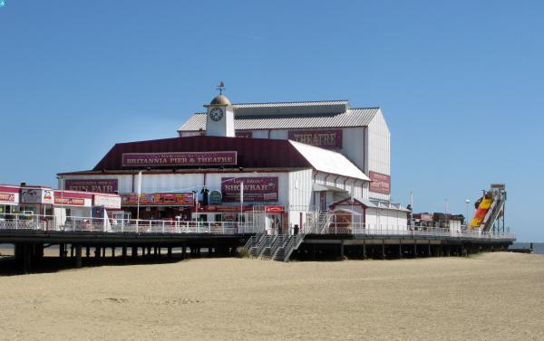
An interesting picture . It shows repairs to the pier after it was cut in half in case of a German invasion in 1940 It is possible to walk around the pier on the beach at the sea end as the beach has made up so much in the last few years. |
pebble |
Saturday 19th of October 2013 03:26:06 PM |