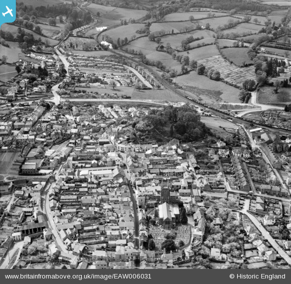
EAW006031 ENGLAND (1947). St Mary's Church, Totnes Castle and the town centre, Totnes, 1947
© Hawlfraint cyfranwyr OpenStreetMap a thrwyddedwyd gan yr OpenStreetMap Foundation. 2024. Trwyddedir y gartograffeg fel CC BY-SA.
Delweddau cyfagos (8)
Manylion
| Pennawd | [EAW006031] St Mary's Church, Totnes Castle and the town centre, Totnes, 1947 |
| Cyfeirnod | EAW006031 |
| Dyddiad | 18-May-1947 |
| Dolen | |
| Enw lle | TOTNES |
| Plwyf | TOTNES |
| Ardal | |
| Gwlad | ENGLAND |
| Dwyreiniad / Gogleddiad | 280039, 60491 |
| Hydred / Lledred | -3.6892343172783, 50.431395634508 |
| Cyfeirnod Grid Cenedlaethol | SX800605 |
Pinnau
 Ginny |
Monday 8th of June 2020 12:24:27 PM | |
 Alan R |
Sunday 1st of March 2015 04:08:45 PM | |
Sarah Hoile |
Friday 27th of June 2014 12:33:49 PM | |
 MB |
Thursday 7th of November 2013 08:51:21 PM | |
 MB |
Thursday 7th of November 2013 08:49:43 PM | |
 MB |
Thursday 7th of November 2013 08:47:34 PM |


![[EAW006031] St Mary's Church, Totnes Castle and the town centre, Totnes, 1947](http://britainfromabove.org.uk/sites/all/libraries/aerofilms-images/public/100x100/EAW/006/EAW006031.jpg)
![[EAW006029] Totnes Castle and the town centre, Totnes, 1947. This image has been produced from a print marked by Aerofilms Ltd for photo-editing.](http://britainfromabove.org.uk/sites/all/libraries/aerofilms-images/public/100x100/EAW/006/EAW006029.jpg)
![[EAW006033] Totnes Castle and environs, Totnes, 1947. This image has been produced from a print.](http://britainfromabove.org.uk/sites/all/libraries/aerofilms-images/public/100x100/EAW/006/EAW006033.jpg)
![[EAW006030] Totnes Castle and the town centre, Totnes, 1947. This image has been produced from a print.](http://britainfromabove.org.uk/sites/all/libraries/aerofilms-images/public/100x100/EAW/006/EAW006030.jpg)
![[EPW011315] The town, Totnes, 1924. This image has been produced from a print.](http://britainfromabove.org.uk/sites/all/libraries/aerofilms-images/public/100x100/EPW/011/EPW011315.jpg)
![[EPW054791] St Mary's Church and environs, Totnes, 1937. This image has been produced from a copy-negative.](http://britainfromabove.org.uk/sites/all/libraries/aerofilms-images/public/100x100/EPW/054/EPW054791.jpg)
![[EPW054790] St Mary's Church and the High Street, Totnes, 1937. This image has been produced from a copy-negative.](http://britainfromabove.org.uk/sites/all/libraries/aerofilms-images/public/100x100/EPW/054/EPW054790.jpg)
![[EAW006032] Totnes Castle and environs, Totnes, 1947. This image has been produced from a print marked by Aerofilms Ltd for photo-editing.](http://britainfromabove.org.uk/sites/all/libraries/aerofilms-images/public/100x100/EAW/006/EAW006032.jpg)