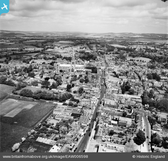
EAW006598 ENGLAND (1947). Southgate, South Street and the city, Chichester, from the south, 1947
© Hawlfraint cyfranwyr OpenStreetMap a thrwyddedwyd gan yr OpenStreetMap Foundation. 2025. Trwyddedir y gartograffeg fel CC BY-SA.
Delweddau cyfagos (16)
Manylion
| Pennawd | [EAW006598] Southgate, South Street and the city, Chichester, from the south, 1947 |
| Cyfeirnod | EAW006598 |
| Dyddiad | 27-May-1947 |
| Dolen | |
| Enw lle | CHICHESTER |
| Plwyf | CHICHESTER |
| Ardal | |
| Gwlad | ENGLAND |
| Dwyreiniad / Gogleddiad | 485997, 104536 |
| Hydred / Lledred | -0.77867316875956, 50.833399721119 |
| Cyfeirnod Grid Cenedlaethol | SU860045 |
Pinnau
 The Laird |
Wednesday 6th of March 2019 07:50:46 PM | |
 The Laird |
Wednesday 6th of March 2019 07:47:05 PM | |
 The Laird |
Wednesday 6th of March 2019 07:46:08 PM | |
 flyer |
Wednesday 2nd of April 2014 04:04:58 PM | |
 flyer |
Wednesday 2nd of April 2014 04:04:09 PM | |
 flyer |
Wednesday 2nd of April 2014 04:03:07 PM | |
 JerryE |
Sunday 29th of December 2013 02:42:07 PM | |
 JerryE |
Sunday 29th of December 2013 02:40:23 PM | |
 JerryE |
Sunday 29th of December 2013 02:37:04 PM | |
 Alan McFaden |
Monday 11th of November 2013 05:30:20 PM | |
 Alan McFaden |
Monday 11th of November 2013 05:29:30 PM | |
 Alan McFaden |
Monday 11th of November 2013 05:28:43 PM | |
 Alan McFaden |
Monday 11th of November 2013 05:28:10 PM |

![[EAW006598] Southgate, South Street and the city, Chichester, from the south, 1947](http://britainfromabove.org.uk/sites/all/libraries/aerofilms-images/public/100x100/EAW/006/EAW006598.jpg)
![[EAW026211] Cathedral of the Holy Trinity and the city centre, Chichester, 1949](http://britainfromabove.org.uk/sites/all/libraries/aerofilms-images/public/100x100/EAW/026/EAW026211.jpg)
![[EAW018183] The city centre, Chichester, from the south, 1948. This image has been produced from a print.](http://britainfromabove.org.uk/sites/all/libraries/aerofilms-images/public/100x100/EAW/018/EAW018183.jpg)
![[EAW028775] Chichester Cathedral, South Street and the city centre, Chichester, 1950](http://britainfromabove.org.uk/sites/all/libraries/aerofilms-images/public/100x100/EAW/028/EAW028775.jpg)
![[EAW006597] The city, Chichester, from the south-east, 1947](http://britainfromabove.org.uk/sites/all/libraries/aerofilms-images/public/100x100/EAW/006/EAW006597.jpg)
![[EAW028774] Chichester Cathedral, South Street and the city centre, Chichester, 1950](http://britainfromabove.org.uk/sites/all/libraries/aerofilms-images/public/100x100/EAW/028/EAW028774.jpg)
![[EPW000232] Chichester Cathedral, Chichester, 1920](http://britainfromabove.org.uk/sites/all/libraries/aerofilms-images/public/100x100/EPW/000/EPW000232.jpg)
![[EPW000665] The Cathedral of the Holy Trinity, Chichester, from the south-west, 1920](http://britainfromabove.org.uk/sites/all/libraries/aerofilms-images/public/100x100/EPW/000/EPW000665.jpg)
![[EPW000230] Chichester Cathedral, Chichester, 1920](http://britainfromabove.org.uk/sites/all/libraries/aerofilms-images/public/100x100/EPW/000/EPW000230.jpg)
![[EAW029568] Chichester Cathedral and the town, Chichester, 1950](http://britainfromabove.org.uk/sites/all/libraries/aerofilms-images/public/100x100/EAW/029/EAW029568.jpg)
![[EPW000231] Chichester Cathedral, Chichester, 1920](http://britainfromabove.org.uk/sites/all/libraries/aerofilms-images/public/100x100/EPW/000/EPW000231.jpg)
![[EPW022958] Chichester Cathedral, Chichester, 1928](http://britainfromabove.org.uk/sites/all/libraries/aerofilms-images/public/100x100/EPW/022/EPW022958.jpg)
![[EPW022959] Chichester Cathedral, Chichester, 1928](http://britainfromabove.org.uk/sites/all/libraries/aerofilms-images/public/100x100/EPW/022/EPW022959.jpg)
![[EPW011550] Chichester Cathedral, Chichester, 1924. This image has been produced from a copy-negative.](http://britainfromabove.org.uk/sites/all/libraries/aerofilms-images/public/100x100/EPW/011/EPW011550.jpg)
![[EAW018179] The Cathedral Church of the Holy Trinity, Chichester, from the south-west, 1948. This image has been produced from a print.](http://britainfromabove.org.uk/sites/all/libraries/aerofilms-images/public/100x100/EAW/018/EAW018179.jpg)
![[EAW018168] The Wingard (M.A.) Ltd Factory, Chichester, 1948](http://britainfromabove.org.uk/sites/all/libraries/aerofilms-images/public/100x100/EAW/018/EAW018168.jpg)
