
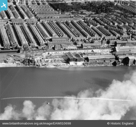
EAW010698 ENGLAND (1947). The Vickers-Armstrongs Ltd Elswick Works and environs, Elswick, 1947. This image was marked by Aerofilms Ltd for photo editing.
© Hawlfraint cyfranwyr OpenStreetMap a thrwyddedwyd gan yr OpenStreetMap Foundation. 2025. Trwyddedir y gartograffeg fel CC BY-SA.
Delweddau cyfagos (5)
EAW010698

EAW010687

EAW010688

EAW010697

EAW010686

Manylion
| Pennawd | [EAW010698] The Vickers-Armstrongs Ltd Elswick Works and environs, Elswick, 1947. This image was marked by Aerofilms Ltd for photo editing. |
| Cyfeirnod | EAW010698 |
| Dyddiad | 10-September-1947 |
| Dolen | |
| Enw lle | ELSWICK |
| Plwyf | |
| Ardal | |
| Gwlad | ENGLAND |
| Dwyreiniad / Gogleddiad | 422152, 563257 |
| Hydred / Lledred | -1.6539856499101, 54.96337353666 |
| Cyfeirnod Grid Cenedlaethol | NZ222633 |
Pinnau
 Sparky |
Tuesday 15th of August 2017 11:08:30 PM |
Cyfraniadau Grŵp
st johns cemetry at the top on st johns road, the shops at the junction were the coop, on budle road, the straight bank is hannah street down onto amelia street,many the streets in benwell and elswick were said to be named after the armstrongs family,edgeware road away down from the cemetry to the forge and hammer on scotswood road,and the hydraulic crane on scotswood road, the fire station was at the bottom of hannah street,also the pipetrack lane can be seen cutting through the terraces from st johns road it went right through to atkinson road,on armstrong road you can see suttons dwellings, |
jacqueline hollis |
Monday 4th of May 2015 12:52:48 AM |