
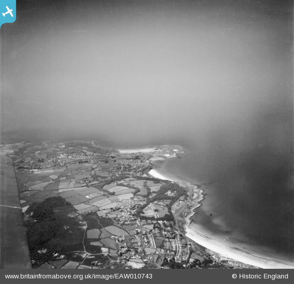
EAW010743 ENGLAND (1947). The coastline from Porthminster to St Ives Head and Clodgy Point, St Ives, from the south-east, 1947
© Hawlfraint cyfranwyr OpenStreetMap a thrwyddedwyd gan yr OpenStreetMap Foundation. 2025. Trwyddedir y gartograffeg fel CC BY-SA.
Delweddau cyfagos (2)
EAW010743

EPW021753

Manylion
| Pennawd | [EAW010743] The coastline from Porthminster to St Ives Head and Clodgy Point, St Ives, from the south-east, 1947 |
| Cyfeirnod | EAW010743 |
| Dyddiad | 10-September-1947 |
| Dolen | |
| Enw lle | ST IVES |
| Plwyf | ST. IVES |
| Ardal | |
| Gwlad | ENGLAND |
| Dwyreiniad / Gogleddiad | 152077, 39549 |
| Hydred / Lledred | -5.4747601916897, 50.203317974259 |
| Cyfeirnod Grid Cenedlaethol | SW521395 |
Pinnau
 redmist |
Wednesday 15th of July 2020 08:17:26 PM | |
redmist |
Wednesday 15th of July 2020 08:13:21 PM | |
redmist |
Wednesday 15th of July 2020 08:11:24 PM | |
redmist |
Wednesday 15th of July 2020 08:10:10 PM | |
redmist |
Wednesday 15th of July 2020 08:08:42 PM | |
redmist |
Wednesday 15th of July 2020 08:07:31 PM | |
andy308 |
Wednesday 8th of October 2014 12:28:04 PM | |
CornwallPhil |
Monday 1st of September 2014 08:44:21 PM | |
CornwallPhil |
Monday 1st of September 2014 08:40:00 PM | |
CornwallPhil |
Monday 1st of September 2014 08:37:48 PM |
Cyfraniadau Grŵp
The large white blob at the bottom centre is providence mine waste dump. You can just make out Higgs Engine House remains to the left of the dump. The waste dump is now White House Close, Carbis bay. Bungalows are built right over the adits and shafts in that area. 200 years of rotting timbers hold up the backfilled land, surely its just a matter of time before the whole estate starts sinking into the voids below. |
andy308 |
Tuesday 7th of October 2014 03:21:16 PM |
 Pillboxes at St Ives |
CornwallPhil |
Monday 1st of September 2014 08:45:24 PM |