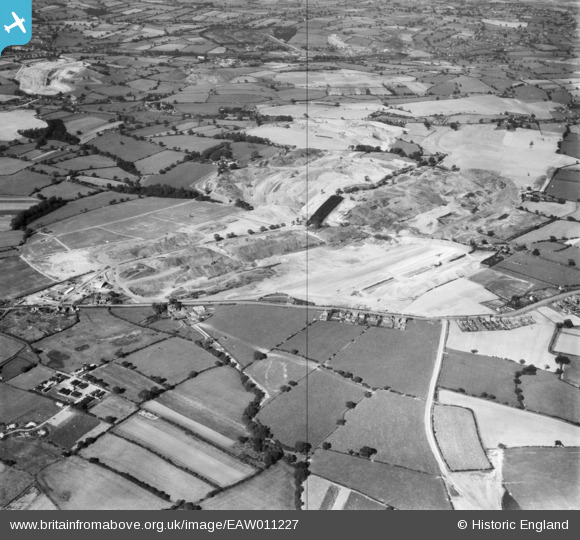
EAW011227 ENGLAND (1947). Opencast coal mining to the north of Heanor Road, Smalley, 1947
© Hawlfraint cyfranwyr OpenStreetMap a thrwyddedwyd gan yr OpenStreetMap Foundation. 2025. Trwyddedir y gartograffeg fel CC BY-SA.
Delweddau cyfagos (9)
Manylion
| Pennawd | [EAW011227] Opencast coal mining to the north of Heanor Road, Smalley, 1947 |
| Cyfeirnod | EAW011227 |
| Dyddiad | 30-September-1947 |
| Dolen | |
| Enw lle | SMALLEY |
| Plwyf | SMALLEY |
| Ardal | |
| Gwlad | ENGLAND |
| Dwyreiniad / Gogleddiad | 441494, 345151 |
| Hydred / Lledred | -1.3816171099393, 53.001760496369 |
| Cyfeirnod Grid Cenedlaethol | SK415452 |
Pinnau
 Matt Aldred edob.mattaldred.com |
Friday 13th of October 2023 02:19:03 PM | |
 Dean77 |
Friday 25th of March 2022 07:25:26 AM | |
 Class31 |
Wednesday 23rd of July 2014 03:03:29 PM | |
 Class31 |
Monday 14th of April 2014 11:32:58 AM | |
 Class31 |
Monday 14th of April 2014 11:30:46 AM | |
 Class31 |
Thursday 9th of January 2014 11:32:52 AM |
Cyfraniadau Grŵp
Looking north west |
 Class31 |
Thursday 9th of January 2014 11:32:35 AM |


![[EAW011227] Opencast coal mining to the north of Heanor Road, Smalley, 1947](http://britainfromabove.org.uk/sites/all/libraries/aerofilms-images/public/100x100/EAW/011/EAW011227.jpg)
![[EAW025919] An opencast mining site adjacent to Heanor Road, Smalley, from the south, 1949](http://britainfromabove.org.uk/sites/all/libraries/aerofilms-images/public/100x100/EAW/025/EAW025919.jpg)
![[EAW017953] Opencast coal mining to the north of Carrington's Farm, Smalley, 1948. This image has been produced from a print.](http://britainfromabove.org.uk/sites/all/libraries/aerofilms-images/public/100x100/EAW/017/EAW017953.jpg)
![[EAW017985] Opencast coal mining to the north of Carrington's Farm, Smalley, 1948. This image has been produced from a print.](http://britainfromabove.org.uk/sites/all/libraries/aerofilms-images/public/100x100/EAW/017/EAW017985.jpg)
![[EAW017948] Opencast coal mining to the north of Carrington's Farm, Smalley, 1948. This image has been produced from a print.](http://britainfromabove.org.uk/sites/all/libraries/aerofilms-images/public/100x100/EAW/017/EAW017948.jpg)
![[EAW033475] Restored opencast mining site near Carrington's Farm, Denby Village, 1950. This image was marked by Aerofilms Ltd for photo editing.](http://britainfromabove.org.uk/sites/all/libraries/aerofilms-images/public/100x100/EAW/033/EAW033475.jpg)
![[EAW017955] Opencast coal mining to the north of Carrington's Farm, Smalley, 1948. This image has been produced from a print.](http://britainfromabove.org.uk/sites/all/libraries/aerofilms-images/public/100x100/EAW/017/EAW017955.jpg)
![[EAW017961] Opencast coal mining to the north of Carrington's Farm, Smalley, 1948. This image has been produced from a damaged negative.](http://britainfromabove.org.uk/sites/all/libraries/aerofilms-images/public/100x100/EAW/017/EAW017961.jpg)
![[EAW017954] Opencast coal mining to the north of Carrington's Farm, Smalley, 1948. This image has been produced from a print.](http://britainfromabove.org.uk/sites/all/libraries/aerofilms-images/public/100x100/EAW/017/EAW017954.jpg)