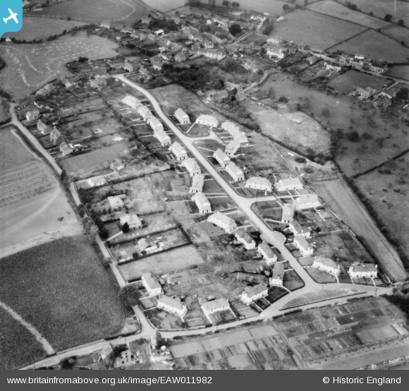
EAW011982 ENGLAND (1947). Houses along Ridgeway and Goss Lane, Nailsea, 1947
© Hawlfraint cyfranwyr OpenStreetMap a thrwyddedwyd gan yr OpenStreetMap Foundation. 2025. Trwyddedir y gartograffeg fel CC BY-SA.
Delweddau cyfagos (11)
Manylion
| Pennawd | [EAW011982] Houses along Ridgeway and Goss Lane, Nailsea, 1947 |
| Cyfeirnod | EAW011982 |
| Dyddiad | 1-November-1947 |
| Dolen | |
| Enw lle | NAILSEA |
| Plwyf | NAILSEA |
| Ardal | |
| Gwlad | ENGLAND |
| Dwyreiniad / Gogleddiad | 346500, 170350 |
| Hydred / Lledred | -2.7696379841277, 51.429134531115 |
| Cyfeirnod Grid Cenedlaethol | ST465704 |
Pinnau
 Marc |
Friday 27th of November 2015 08:34:15 PM | |
 Marc |
Friday 27th of November 2015 08:25:02 PM | |
 Marc |
Friday 27th of November 2015 08:22:06 PM | |
 Marc |
Friday 27th of November 2015 08:19:18 PM | |
 Marc |
Friday 27th of November 2015 08:17:02 PM | |
 Marc |
Friday 27th of November 2015 08:12:03 PM | |
 Gary |
Friday 9th of May 2014 10:38:21 PM |


![[EAW011982] Houses along Ridgeway and Goss Lane, Nailsea, 1947](http://britainfromabove.org.uk/sites/all/libraries/aerofilms-images/public/100x100/EAW/011/EAW011982.jpg)
![[EAW011981] Houses along Ridgeway, Nailsea, 1947. This image was marked by Aerofilms Ltd for photo editing.](http://britainfromabove.org.uk/sites/all/libraries/aerofilms-images/public/100x100/EAW/011/EAW011981.jpg)
![[EAW011978] Houses along Ridgeway, Nailsea, 1947. This image was marked by Aerofilms Ltd for photo editing.](http://britainfromabove.org.uk/sites/all/libraries/aerofilms-images/public/100x100/EAW/011/EAW011978.jpg)
![[EAW011985] Houses along Ridgeway, Nailsea, 1947. This image was marked by Aerofilms Ltd for photo editing.](http://britainfromabove.org.uk/sites/all/libraries/aerofilms-images/public/100x100/EAW/011/EAW011985.jpg)
![[EAW011984] Houses along Ridgeway, Nailsea, 1947](http://britainfromabove.org.uk/sites/all/libraries/aerofilms-images/public/100x100/EAW/011/EAW011984.jpg)
![[EAW011979] Houses along Ridgeway, Nailsea, 1947. This image was marked by Aerofilms Ltd for photo editing.](http://britainfromabove.org.uk/sites/all/libraries/aerofilms-images/public/100x100/EAW/011/EAW011979.jpg)
![[EAW011980] Houses along Ridgeway, Nailsea, 1947. This image was marked by Aerofilms Ltd for photo editing.](http://britainfromabove.org.uk/sites/all/libraries/aerofilms-images/public/100x100/EAW/011/EAW011980.jpg)
![[EAW011975] Houses along Ridgeway and Goss Lane, Nailsea, from the south, 1947](http://britainfromabove.org.uk/sites/all/libraries/aerofilms-images/public/100x100/EAW/011/EAW011975.jpg)
![[EAW011977] Houses along Ridgeway, Nailsea, 1947. This image was marked by Aerofilms Ltd for photo editing.](http://britainfromabove.org.uk/sites/all/libraries/aerofilms-images/public/100x100/EAW/011/EAW011977.jpg)
![[EAW011983] Houses along Ridgeway, Nailsea, 1947](http://britainfromabove.org.uk/sites/all/libraries/aerofilms-images/public/100x100/EAW/011/EAW011983.jpg)
![[EAW011976] Houses along Ridgeway, Nailsea, from the north-west, 1947. This image was marked by Aerofilms Ltd for photo editing.](http://britainfromabove.org.uk/sites/all/libraries/aerofilms-images/public/100x100/EAW/011/EAW011976.jpg)