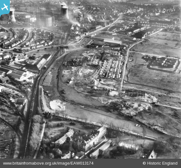
EAW013174 ENGLAND (1948). The Croydon B Power Station under construction, Croydon, 1948
© Hawlfraint cyfranwyr OpenStreetMap a thrwyddedwyd gan yr OpenStreetMap Foundation. 2025. Trwyddedir y gartograffeg fel CC BY-SA.
Delweddau cyfagos (20)
Manylion
| Pennawd | [EAW013174] The Croydon B Power Station under construction, Croydon, 1948 |
| Cyfeirnod | EAW013174 |
| Dyddiad | 9-February-1948 |
| Dolen | |
| Enw lle | CROYDON |
| Plwyf | |
| Ardal | |
| Gwlad | ENGLAND |
| Dwyreiniad / Gogleddiad | 530634, 166337 |
| Hydred / Lledred | -0.12266058594459, 51.380534172267 |
| Cyfeirnod Grid Cenedlaethol | TQ306663 |
Pinnau
 Geoff Smith |
Friday 20th of December 2013 03:47:25 PM | |
 Geoff Smith |
Friday 20th of December 2013 03:43:40 PM | |
 Geoff Smith |
Friday 20th of December 2013 03:42:50 PM | |
 Geoff Smith |
Friday 20th of December 2013 03:42:07 PM | |
Geoff, i went to this hospital in the very early 60s when i had scarlet fever & had a faint recollection of where it was, now you have confirmed the location, thanks. |
 john bagley |
Friday 23rd of October 2015 02:32:32 PM |
 Geoff Smith |
Friday 20th of December 2013 03:41:11 PM |


![[EAW013174] The Croydon B Power Station under construction, Croydon, 1948](http://britainfromabove.org.uk/sites/all/libraries/aerofilms-images/public/100x100/EAW/013/EAW013174.jpg)
![[EAW026596] Croydon B Power Station under construction, Croydon, 1949. This image has been produced from a print marked by Aerofilms Ltd for photo editing.](http://britainfromabove.org.uk/sites/all/libraries/aerofilms-images/public/100x100/EAW/026/EAW026596.jpg)
![[EAW013172] The Croydon B Power Station under construction, Croydon, 1948](http://britainfromabove.org.uk/sites/all/libraries/aerofilms-images/public/100x100/EAW/013/EAW013172.jpg)
![[EAW026600] Croydon B Power Station under construction, Croydon, 1949. This image has been produced from a print marked by Aerofilms Ltd for photo editing.](http://britainfromabove.org.uk/sites/all/libraries/aerofilms-images/public/100x100/EAW/026/EAW026600.jpg)
![[EAW026597] Croydon B Power Station under construction, Croydon, 1949. This image has been produced from a print marked by Aerofilms Ltd for photo editing.](http://britainfromabove.org.uk/sites/all/libraries/aerofilms-images/public/100x100/EAW/026/EAW026597.jpg)
![[EAW013173] The Croydon B Power Station under construction, Croydon, 1948](http://britainfromabove.org.uk/sites/all/libraries/aerofilms-images/public/100x100/EAW/013/EAW013173.jpg)
![[EAW013176] The Croydon B Power Station under construction, Croydon, 1948](http://britainfromabove.org.uk/sites/all/libraries/aerofilms-images/public/100x100/EAW/013/EAW013176.jpg)
![[EAW013171] The Croydon B Power Station under construction, Croydon, 1948](http://britainfromabove.org.uk/sites/all/libraries/aerofilms-images/public/100x100/EAW/013/EAW013171.jpg)
![[EAW013178] The Croydon B Power Station and Cooling Towers under construction, Croydon, 1948](http://britainfromabove.org.uk/sites/all/libraries/aerofilms-images/public/100x100/EAW/013/EAW013178.jpg)
![[EAW026598] Croydon B Power Station under construction, Croydon, 1949. This image has been produced from a print marked by Aerofilms Ltd for photo editing.](http://britainfromabove.org.uk/sites/all/libraries/aerofilms-images/public/100x100/EAW/026/EAW026598.jpg)
![[EAW013177] The Croydon B Power Station and Cooling Towers under construction, Croydon, 1948](http://britainfromabove.org.uk/sites/all/libraries/aerofilms-images/public/100x100/EAW/013/EAW013177.jpg)
![[EAW026588] Croydon B Power Station and Cooling Towers under construction, Croydon, 1949. This image has been produced from a print marked by Aerofilms Ltd for photo editing.](http://britainfromabove.org.uk/sites/all/libraries/aerofilms-images/public/100x100/EAW/026/EAW026588.jpg)
![[EAW026590] Croydon B Power Station and Cooling Towers under construction, Croydon, 1949. This image has been produced from a print marked by Aerofilms Ltd for photo editing.](http://britainfromabove.org.uk/sites/all/libraries/aerofilms-images/public/100x100/EAW/026/EAW026590.jpg)
![[EAW013182] The Croydon B Power Station and Cooling Towers under construction, Croydon, 1948. This image has been produced from a print.](http://britainfromabove.org.uk/sites/all/libraries/aerofilms-images/public/100x100/EAW/013/EAW013182.jpg)
![[EAW013183] The Croydon B Power Station and Cooling Towers under construction, Croydon, 1948. This image has been produced from a print.](http://britainfromabove.org.uk/sites/all/libraries/aerofilms-images/public/100x100/EAW/013/EAW013183.jpg)
![[EAW013175] The Croydon B Power Station and Cooling Towers under construction, Croydon, 1948](http://britainfromabove.org.uk/sites/all/libraries/aerofilms-images/public/100x100/EAW/013/EAW013175.jpg)
![[EAW013180] The Croydon B Power Station and Cooling Towers under construction and Beddington Sewage Works, Croydon, 1948. This image has been produced from a damaged negative.](http://britainfromabove.org.uk/sites/all/libraries/aerofilms-images/public/100x100/EAW/013/EAW013180.jpg)
![[EAW026589] Croydon B Power Station and Cooling Towers under construction, Croydon, 1949. This image has been produced from a print marked by Aerofilms Ltd for photo editing.](http://britainfromabove.org.uk/sites/all/libraries/aerofilms-images/public/100x100/EAW/026/EAW026589.jpg)
![[EAW026595] Croydon B Power Station and Cooling Towers under construction, Croydon, 1949. This image has been produced from a print marked by Aerofilms Ltd for photo editing.](http://britainfromabove.org.uk/sites/all/libraries/aerofilms-images/public/100x100/EAW/026/EAW026595.jpg)
![[EAW026591] Croydon B Power Station and Cooling Towers under construction, Croydon, 1949. This image has been produced from a print marked by Aerofilms Ltd for photo editing.](http://britainfromabove.org.uk/sites/all/libraries/aerofilms-images/public/100x100/EAW/026/EAW026591.jpg)