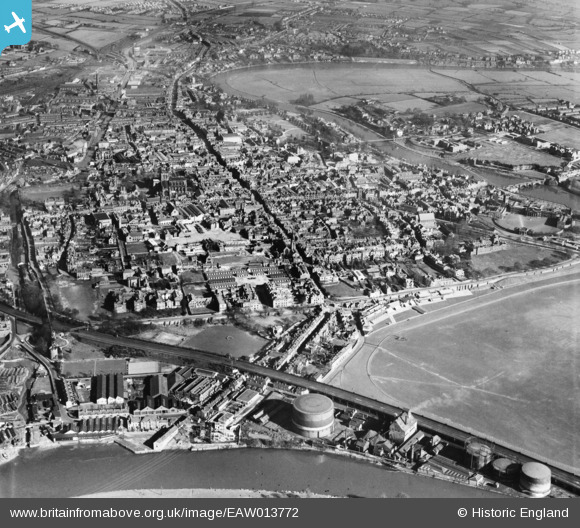
EAW013772 ENGLAND (1948). The city centre, Chester, 1948
© Hawlfraint cyfranwyr OpenStreetMap a thrwyddedwyd gan yr OpenStreetMap Foundation. 2025. Trwyddedir y gartograffeg fel CC BY-SA.
Delweddau cyfagos (11)
Manylion
| Pennawd | [EAW013772] The city centre, Chester, 1948 |
| Cyfeirnod | EAW013772 |
| Dyddiad | 11-March-1948 |
| Dolen | |
| Enw lle | CHESTER |
| Plwyf | |
| Ardal | |
| Gwlad | ENGLAND |
| Dwyreiniad / Gogleddiad | 340309, 366234 |
| Hydred / Lledred | -2.8934590510328, 53.189556011345 |
| Cyfeirnod Grid Cenedlaethol | SJ403662 |
Pinnau
 Matt Aldred edob.mattaldred.com |
Sunday 6th of February 2022 08:26:23 PM | |
 redmist |
Wednesday 2nd of October 2019 11:54:53 PM | |
 knowhowe |
Tuesday 15th of July 2014 12:22:39 AM | |
 knowhowe |
Tuesday 15th of July 2014 12:21:29 AM | |
 chriskay |
Wednesday 22nd of January 2014 01:02:14 PM | |
 chriskay |
Wednesday 22nd of January 2014 01:01:23 PM | |
 chriskay |
Wednesday 22nd of January 2014 01:00:49 PM | |
 chriskay |
Wednesday 22nd of January 2014 01:00:18 PM | |
 chriskay |
Wednesday 22nd of January 2014 12:58:59 PM | |
 chriskay |
Wednesday 22nd of January 2014 12:58:22 PM | |
 chriskay |
Wednesday 22nd of January 2014 12:57:35 PM | |
 beast66606 |
Monday 2nd of December 2013 08:50:15 PM |


![[EAW013772] The city centre, Chester, 1948](http://britainfromabove.org.uk/sites/all/libraries/aerofilms-images/public/100x100/EAW/013/EAW013772.jpg)
![[EPW036910] Watergate Street, Chester, 1931](http://britainfromabove.org.uk/sites/all/libraries/aerofilms-images/public/100x100/EPW/036/EPW036910.jpg)
![[EPW003093] General view of the city centre, Chester, 1920](http://britainfromabove.org.uk/sites/all/libraries/aerofilms-images/public/100x100/EPW/003/EPW003093.jpg)
![[EPW058009] The city centre, Chester, 1938. This image has been produced from a print.](http://britainfromabove.org.uk/sites/all/libraries/aerofilms-images/public/100x100/EPW/058/EPW058009.jpg)
![[EPW005883] The city, Chester, 1921. This image has been produced from a copy-negative.](http://britainfromabove.org.uk/sites/all/libraries/aerofilms-images/public/100x100/EPW/005/EPW005883.jpg)
![[EPW029884] Watergate Street and Eastgate Street, Chester, 1929](http://britainfromabove.org.uk/sites/all/libraries/aerofilms-images/public/100x100/EPW/029/EPW029884.jpg)
![[EPW058010] Chester Cathedral and the town centre, Chester, 1938](http://britainfromabove.org.uk/sites/all/libraries/aerofilms-images/public/100x100/EPW/058/EPW058010.jpg)
![[EPW037241] Eastgate Street and the city centre, Chester, 1931](http://britainfromabove.org.uk/sites/all/libraries/aerofilms-images/public/100x100/EPW/037/EPW037241.jpg)
![[EAW013771] The city centre, Chester, 1948](http://britainfromabove.org.uk/sites/all/libraries/aerofilms-images/public/100x100/EAW/013/EAW013771.jpg)
![[EPW005884] Bridge Street, Chester, 1921. This image has been produced from a copy-negative.](http://britainfromabove.org.uk/sites/all/libraries/aerofilms-images/public/100x100/EPW/005/EPW005884.jpg)
![[EPW011200] The Cathedral and view of the city, Chester, from the west, 1924](http://britainfromabove.org.uk/sites/all/libraries/aerofilms-images/public/100x100/EPW/011/EPW011200.jpg)