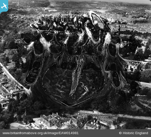
EAW014981 ENGLAND (1948). Lower Warberry Road and environs, Torquay, from the south-east, 1948. This image has been produced from a damaged negative.
© Hawlfraint cyfranwyr OpenStreetMap a thrwyddedwyd gan yr OpenStreetMap Foundation. 2024. Trwyddedir y gartograffeg fel CC BY-SA.
Delweddau cyfagos (13)
Manylion
| Pennawd | [EAW014981] Lower Warberry Road and environs, Torquay, from the south-east, 1948. This image has been produced from a damaged negative. |
| Cyfeirnod | EAW014981 |
| Dyddiad | 27-April-1948 |
| Dolen | |
| Enw lle | TORQUAY |
| Plwyf | |
| Ardal | |
| Gwlad | ENGLAND |
| Dwyreiniad / Gogleddiad | 292326, 63999 |
| Hydred / Lledred | -3.5172912485672, 50.465318724041 |
| Cyfeirnod Grid Cenedlaethol | SX923640 |
Pinnau
 Class31 |
Tuesday 1st of April 2014 12:56:48 PM | |
 Class31 |
Tuesday 1st of April 2014 12:54:14 PM |


![[EAW014981] Lower Warberry Road and environs, Torquay, from the south-east, 1948. This image has been produced from a damaged negative.](http://britainfromabove.org.uk/sites/all/libraries/aerofilms-images/public/100x100/EAW/014/EAW014981.jpg)
![[EAW014982] Normount and adjacent properties on Middle Warberry Road, Torquay, 1948. This image has been produced from a print marked by Aerofilms Ltd for photo editing.](http://britainfromabove.org.uk/sites/all/libraries/aerofilms-images/public/100x100/EAW/014/EAW014982.jpg)
![[EAW014979] Normount and adjacent properties on Middle Warberry Road, Torquay, 1948. This image was marked by Aerofilms Ltd for photo editing.](http://britainfromabove.org.uk/sites/all/libraries/aerofilms-images/public/100x100/EAW/014/EAW014979.jpg)
![[EAW014980] Normount and adjacent properties on Middle Warberry Road, Torquay, from the south-east, 1948](http://britainfromabove.org.uk/sites/all/libraries/aerofilms-images/public/100x100/EAW/014/EAW014980.jpg)
![[EAW014983] Normount and adjacent properties on Middle Warberry Road, Torquay, 1948. This image has been produced from a print marked by Aerofilms Ltd for photo editing.](http://britainfromabove.org.uk/sites/all/libraries/aerofilms-images/public/100x100/EAW/014/EAW014983.jpg)
![[EPW023729] Warberry Hill and environs, Torquay, 1928](http://britainfromabove.org.uk/sites/all/libraries/aerofilms-images/public/100x100/EPW/023/EPW023729.jpg)
![[EAW007769] Warberry Court, Torquay, 1947](http://britainfromabove.org.uk/sites/all/libraries/aerofilms-images/public/100x100/EAW/007/EAW007769.jpg)
![[EAW007764] Warberry Court, Torquay, 1947](http://britainfromabove.org.uk/sites/all/libraries/aerofilms-images/public/100x100/EAW/007/EAW007764.jpg)
![[EAW007767] Warberry Court, Torquay, 1947](http://britainfromabove.org.uk/sites/all/libraries/aerofilms-images/public/100x100/EAW/007/EAW007767.jpg)
![[EAW007766] Warberry Court, Torquay, 1947](http://britainfromabove.org.uk/sites/all/libraries/aerofilms-images/public/100x100/EAW/007/EAW007766.jpg)
![[EAW007768] Warberry Court, Torquay, 1947](http://britainfromabove.org.uk/sites/all/libraries/aerofilms-images/public/100x100/EAW/007/EAW007768.jpg)
![[EAW007763] Warberry Court, Torquay, 1947](http://britainfromabove.org.uk/sites/all/libraries/aerofilms-images/public/100x100/EAW/007/EAW007763.jpg)
![[EAW007765] Warberry Court, Torquay, 1947](http://britainfromabove.org.uk/sites/all/libraries/aerofilms-images/public/100x100/EAW/007/EAW007765.jpg)