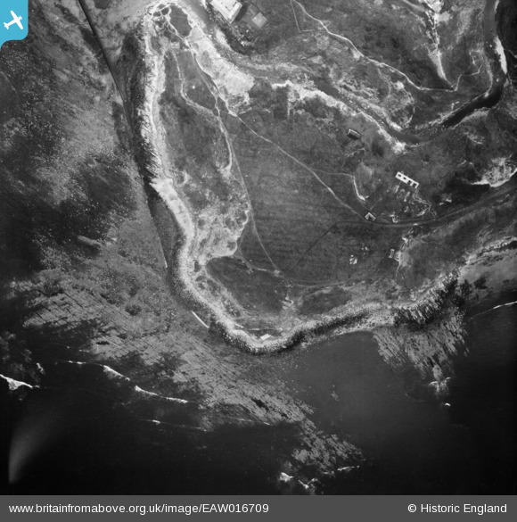
EAW016709 ENGLAND (1948). Long Nab, Scalby Ness Rocks, 1948
© Hawlfraint cyfranwyr OpenStreetMap a thrwyddedwyd gan yr OpenStreetMap Foundation. 2025. Trwyddedir y gartograffeg fel CC BY-SA.
Delweddau cyfagos (13)
Manylion
| Pennawd | [EAW016709] Long Nab, Scalby Ness Rocks, 1948 |
| Cyfeirnod | EAW016709 |
| Dyddiad | 23-June-1948 |
| Dolen | |
| Enw lle | SCALBY NESS ROCKS |
| Plwyf | NEWBY AND SCALBY |
| Ardal | |
| Gwlad | ENGLAND |
| Dwyreiniad / Gogleddiad | 503637, 491037 |
| Hydred / Lledred | -0.4070961176315, 54.30425293789 |
| Cyfeirnod Grid Cenedlaethol | TA036910 |
Pinnau
 Matt Aldred edob.mattaldred.com |
Thursday 11th of March 2021 12:23:53 PM | |
 Matt Aldred edob.mattaldred.com |
Thursday 11th of March 2021 12:23:42 PM | |
 Matt Aldred edob.mattaldred.com |
Thursday 11th of March 2021 12:23:29 PM | |
 redmist |
Saturday 19th of October 2019 07:29:29 PM | |
 redmist |
Saturday 19th of October 2019 07:29:15 PM | |
 redmist |
Saturday 19th of October 2019 07:28:35 PM | |
 redmist |
Saturday 19th of October 2019 07:27:44 PM |


![[EAW016709] Long Nab, Scalby Ness Rocks, 1948](http://britainfromabove.org.uk/sites/all/libraries/aerofilms-images/public/100x100/EAW/016/EAW016709.jpg)
![[EAW016702] Long Nab and Colley's Cosy Holiday Camp, Scalby Ness Rocks, 1948](http://britainfromabove.org.uk/sites/all/libraries/aerofilms-images/public/100x100/EAW/016/EAW016702.jpg)
![[EAW016705] Long Nab, Scalby Ness Rocks, 1948](http://britainfromabove.org.uk/sites/all/libraries/aerofilms-images/public/100x100/EAW/016/EAW016705.jpg)
![[EAW016703] Long Nab, Scalby Ness Rocks, 1948](http://britainfromabove.org.uk/sites/all/libraries/aerofilms-images/public/100x100/EAW/016/EAW016703.jpg)
![[EAW016701] Long Nab and Colley's Cosy Holiday Camp, Scalby Ness Rocks, 1948](http://britainfromabove.org.uk/sites/all/libraries/aerofilms-images/public/100x100/EAW/016/EAW016701.jpg)
![[EAW016708] Long Nab, Scalby Ness Rocks, 1948](http://britainfromabove.org.uk/sites/all/libraries/aerofilms-images/public/100x100/EAW/016/EAW016708.jpg)
![[EAW016707] Long Nab, Scalby Ness Rocks, 1948](http://britainfromabove.org.uk/sites/all/libraries/aerofilms-images/public/100x100/EAW/016/EAW016707.jpg)
![[EAW016704] Long Nab, Scalby Ness Rocks, 1948](http://britainfromabove.org.uk/sites/all/libraries/aerofilms-images/public/100x100/EAW/016/EAW016704.jpg)
![[EAW016706] Long Nab and Colley's Cosy Holiday Camp, Scalby Ness Rocks, 1948](http://britainfromabove.org.uk/sites/all/libraries/aerofilms-images/public/100x100/EAW/016/EAW016706.jpg)
![[EAW010306] Colley's Cosy Camp at the end of Scholes Park Road, Scarborough, from the south-east, 1947](http://britainfromabove.org.uk/sites/all/libraries/aerofilms-images/public/100x100/EAW/010/EAW010306.jpg)
![[EAW010304] Colley's Cosy Camp at the end of Scholes Park Road, Scarborough, 1947](http://britainfromabove.org.uk/sites/all/libraries/aerofilms-images/public/100x100/EAW/010/EAW010304.jpg)
![[EAW010303] Colley's Cosy Camp at the end of Scholes Park Road, Scarborough, 1947](http://britainfromabove.org.uk/sites/all/libraries/aerofilms-images/public/100x100/EAW/010/EAW010303.jpg)
![[EAW010305] Colley's Cosy Camp at the end of Scholes Park Road, Scarborough, 1947](http://britainfromabove.org.uk/sites/all/libraries/aerofilms-images/public/100x100/EAW/010/EAW010305.jpg)