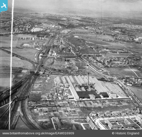
EAW016909 ENGLAND (1948). The Cooperative Wholesale Society Ltd Pelaw Works along Shields Road, Bill Quay, from the east, 1948. This image has been produced from a print marked by Aerofilms Ltd for photo editing.
© Hawlfraint cyfranwyr OpenStreetMap a thrwyddedwyd gan yr OpenStreetMap Foundation. 2025. Trwyddedir y gartograffeg fel CC BY-SA.
Delweddau cyfagos (12)
Manylion
| Pennawd | [EAW016909] The Cooperative Wholesale Society Ltd Pelaw Works along Shields Road, Bill Quay, from the east, 1948. This image has been produced from a print marked by Aerofilms Ltd for photo editing. |
| Cyfeirnod | EAW016909 |
| Dyddiad | 30-June-1948 |
| Dolen | |
| Enw lle | BILL QUAY |
| Plwyf | |
| Ardal | |
| Gwlad | ENGLAND |
| Dwyreiniad / Gogleddiad | 429856, 562301 |
| Hydred / Lledred | -1.5337524868451, 54.954380092095 |
| Cyfeirnod Grid Cenedlaethol | NZ299623 |
Pinnau
 ozzie1980 |
Monday 29th of April 2024 02:32:03 PM | |
 redmist |
Sunday 2nd of October 2022 10:44:23 AM | |
 redmist |
Sunday 2nd of October 2022 10:37:26 AM | |
 redmist |
Sunday 2nd of October 2022 10:34:55 AM | |
 N Dunn |
Friday 17th of November 2017 01:22:53 PM | |
 N Dunn |
Friday 17th of November 2017 01:21:53 PM | |
 N Dunn |
Friday 17th of November 2017 01:17:31 PM | |
 N Dunn |
Friday 17th of November 2017 01:13:43 PM |


![[EAW016909] The Cooperative Wholesale Society Ltd Pelaw Works along Shields Road, Bill Quay, from the east, 1948. This image has been produced from a print marked by Aerofilms Ltd for photo editing.](http://britainfromabove.org.uk/sites/all/libraries/aerofilms-images/public/100x100/EAW/016/EAW016909.jpg)
![[EPW060860] The Co-operative Wholesale Society Cabinet Works, Pelaw, 1939](http://britainfromabove.org.uk/sites/all/libraries/aerofilms-images/public/100x100/EPW/060/EPW060860.jpg)
![[EPW060857] The Co-operative Wholesale Society Cabinet Works, Pelaw, 1939](http://britainfromabove.org.uk/sites/all/libraries/aerofilms-images/public/100x100/EPW/060/EPW060857.jpg)
![[EPW060863] The Co-operative Wholesale Society Cabinet Works, Pelaw, 1939](http://britainfromabove.org.uk/sites/all/libraries/aerofilms-images/public/100x100/EPW/060/EPW060863.jpg)
![[EPW060862] The Co-operative Wholesale Society Cabinet Works, Pelaw, 1939](http://britainfromabove.org.uk/sites/all/libraries/aerofilms-images/public/100x100/EPW/060/EPW060862.jpg)
![[EPW060858] The Co-operative Wholesale Society Cabinet Works, Pelaw, 1939](http://britainfromabove.org.uk/sites/all/libraries/aerofilms-images/public/100x100/EPW/060/EPW060858.jpg)
![[EPW060861] The Co-operative Wholesale Society Cabinet Works, Pelaw, 1939](http://britainfromabove.org.uk/sites/all/libraries/aerofilms-images/public/100x100/EPW/060/EPW060861.jpg)
![[EPW060859] The Co-operative Wholesale Society Cabinet Works, Pelaw, 1939](http://britainfromabove.org.uk/sites/all/libraries/aerofilms-images/public/100x100/EPW/060/EPW060859.jpg)
![[EPW060864] The Co-operative Wholesale Society Cabinet Works, Pelaw, 1939](http://britainfromabove.org.uk/sites/all/libraries/aerofilms-images/public/100x100/EPW/060/EPW060864.jpg)
![[EAW016910] The Cooperative Wholesale Society Ltd Pelaw Works along Shields Road, Bill Quay, from the north-east, 1948. This image has been produced from a print marked by Aerofilms Ltd for photo editing.](http://britainfromabove.org.uk/sites/all/libraries/aerofilms-images/public/100x100/EAW/016/EAW016910.jpg)
![[EAW016901] The Cooperative Wholesale Society Ltd Pelaw Works (cabinets) and environs, Bill Quay, 1948. This image has been produced from a print.](http://britainfromabove.org.uk/sites/all/libraries/aerofilms-images/public/100x100/EAW/016/EAW016901.jpg)
![[EAW016902] Housing at Woodgate Gardens opposite the Cooperative Wholesale Society Ltd Pelaw Works (cabinets) and environs, Bill Quay, from the south, 1948. This image has been produced from a print marked by Aerofilms Ltd for photo editing.](http://britainfromabove.org.uk/sites/all/libraries/aerofilms-images/public/100x100/EAW/016/EAW016902.jpg)
