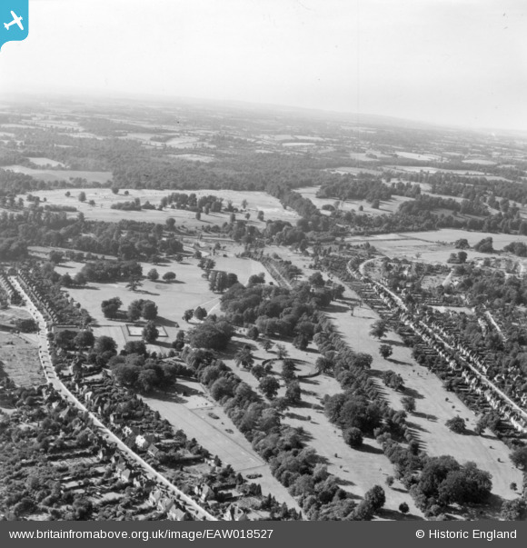
EAW018527 ENGLAND (1948). Cassiobury Park, Watford, from the south-east, 1948. This image has been produced from a print.
© Hawlfraint cyfranwyr OpenStreetMap a thrwyddedwyd gan yr OpenStreetMap Foundation. 2025. Trwyddedir y gartograffeg fel CC BY-SA.
Delweddau cyfagos (8)
Manylion
| Pennawd | [EAW018527] Cassiobury Park, Watford, from the south-east, 1948. This image has been produced from a print. |
| Cyfeirnod | EAW018527 |
| Dyddiad | 9-September-1948 |
| Dolen | |
| Enw lle | WATFORD |
| Plwyf | |
| Ardal | |
| Gwlad | ENGLAND |
| Dwyreiniad / Gogleddiad | 509820, 196796 |
| Hydred / Lledred | -0.41214896363246, 51.658740872643 |
| Cyfeirnod Grid Cenedlaethol | TQ098968 |
Pinnau
 james davis |
Sunday 15th of September 2024 08:26:50 PM | |
 Brad |
Tuesday 17th of July 2018 11:42:37 AM | |
 Brad |
Tuesday 17th of July 2018 11:42:09 AM |


![[EAW018527] Cassiobury Park, Watford, from the south-east, 1948. This image has been produced from a print.](http://britainfromabove.org.uk/sites/all/libraries/aerofilms-images/public/100x100/EAW/018/EAW018527.jpg)
![[EPW021334] The band stand and Cassiobury Park, Watford, 1928](http://britainfromabove.org.uk/sites/all/libraries/aerofilms-images/public/100x100/EPW/021/EPW021334.jpg)
![[EPW019231] The bandstand in Cassiobury Park, West Watford, 1927](http://britainfromabove.org.uk/sites/all/libraries/aerofilms-images/public/100x100/EPW/019/EPW019231.jpg)
![[EPW019232] Cassiobury Park, West Watford, 1927](http://britainfromabove.org.uk/sites/all/libraries/aerofilms-images/public/100x100/EPW/019/EPW019232.jpg)
![[EPW039631] Cassiobury Park, Watford, 1932](http://britainfromabove.org.uk/sites/all/libraries/aerofilms-images/public/100x100/EPW/039/EPW039631.jpg)
![[EPW019234] Cassiobury Park and Cassiobury Park Avenue, West Watford, 1927](http://britainfromabove.org.uk/sites/all/libraries/aerofilms-images/public/100x100/EPW/019/EPW019234.jpg)
![[EPW019233] Cassiobury Park, West Watford, 1927](http://britainfromabove.org.uk/sites/all/libraries/aerofilms-images/public/100x100/EPW/019/EPW019233.jpg)
![[EAW002183] Cassiobury Park, Watford, 1946](http://britainfromabove.org.uk/sites/all/libraries/aerofilms-images/public/100x100/EAW/002/EAW002183.jpg)