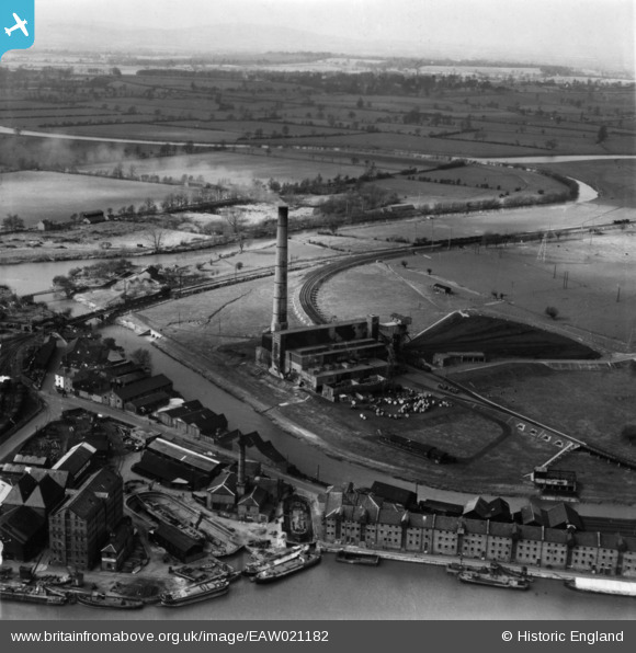
EAW021182 ENGLAND (1949). Castle Meads Power Station and environs, Gloucester, from the east, 1949. This image has been produced from a print.
© Hawlfraint cyfranwyr OpenStreetMap a thrwyddedwyd gan yr OpenStreetMap Foundation. 2025. Trwyddedir y gartograffeg fel CC BY-SA.
Delweddau cyfagos (23)
Manylion
| Pennawd | [EAW021182] Castle Meads Power Station and environs, Gloucester, from the east, 1949. This image has been produced from a print. |
| Cyfeirnod | EAW021182 |
| Dyddiad | 2-March-1949 |
| Dolen | |
| Enw lle | GLOUCESTER |
| Plwyf | |
| Ardal | |
| Gwlad | ENGLAND |
| Dwyreiniad / Gogleddiad | 382566, 218322 |
| Hydred / Lledred | -2.2532038881144, 51.862766178473 |
| Cyfeirnod Grid Cenedlaethol | SO826183 |
Pinnau
 Class31 |
Wednesday 3rd of June 2015 08:28:56 PM |


![[EAW021182] Castle Meads Power Station and environs, Gloucester, from the east, 1949. This image has been produced from a print.](http://britainfromabove.org.uk/sites/all/libraries/aerofilms-images/public/100x100/EAW/021/EAW021182.jpg)
![[EAW021185] Castle Meads Power Station and the docks, Gloucester, 1949. This image has been produced from a print.](http://britainfromabove.org.uk/sites/all/libraries/aerofilms-images/public/100x100/EAW/021/EAW021185.jpg)
![[EAW021181] Castle Meads Power Station and the River Severn East Channel, Gloucester, 1949. This image has been produced from a print marked by Aerofilms Ltd for photo editing.](http://britainfromabove.org.uk/sites/all/libraries/aerofilms-images/public/100x100/EAW/021/EAW021181.jpg)
![[EAW012210] Gloucester Docks and the surrounding industrial area, Gloucester, 1947](http://britainfromabove.org.uk/sites/all/libraries/aerofilms-images/public/100x100/EAW/012/EAW012210.jpg)
![[EAW012209] Gloucester Docks and the surrounding area, Gloucester, 1947](http://britainfromabove.org.uk/sites/all/libraries/aerofilms-images/public/100x100/EAW/012/EAW012209.jpg)
![[EPW037749] The docks, Gloucester, 1932](http://britainfromabove.org.uk/sites/all/libraries/aerofilms-images/public/100x100/EPW/037/EPW037749.jpg)
![[EAW021184] Castle Meads Power Station and environs, Gloucester, from the south, 1949. This image has been produced from a print.](http://britainfromabove.org.uk/sites/all/libraries/aerofilms-images/public/100x100/EAW/021/EAW021184.jpg)
![[EAW021183] Castle Meads Power Station and the city, Gloucester, 1949. This image has been produced from a print.](http://britainfromabove.org.uk/sites/all/libraries/aerofilms-images/public/100x100/EAW/021/EAW021183.jpg)
![[EAW012207] Gloucester Docks and the surrounding warehouses, Gloucester, 1947](http://britainfromabove.org.uk/sites/all/libraries/aerofilms-images/public/100x100/EAW/012/EAW012207.jpg)
![[EPW024161] The Docks, Gloucester, 1928](http://britainfromabove.org.uk/sites/all/libraries/aerofilms-images/public/100x100/EPW/024/EPW024161.jpg)
![[EAW012204] Gloucester Docks and the surrounding warehouses, Gloucester, 1947](http://britainfromabove.org.uk/sites/all/libraries/aerofilms-images/public/100x100/EAW/012/EAW012204.jpg)
![[EAW012200] Gloucester Docks, Gloucester, 1947](http://britainfromabove.org.uk/sites/all/libraries/aerofilms-images/public/100x100/EAW/012/EAW012200.jpg)
![[EAW012202] Gloucester Docks, Gloucester, 1947](http://britainfromabove.org.uk/sites/all/libraries/aerofilms-images/public/100x100/EAW/012/EAW012202.jpg)
![[EAW018728] The site of Llanthony Secunda Priory, Castle Meads and environs, Gloucester, 1948. This image has been produced from a print.](http://britainfromabove.org.uk/sites/all/libraries/aerofilms-images/public/100x100/EAW/018/EAW018728.jpg)
![[EPW037751] The docks and the city, Gloucester, 1932](http://britainfromabove.org.uk/sites/all/libraries/aerofilms-images/public/100x100/EPW/037/EPW037751.jpg)
![[EPW037834] The docks, Gloucester, 1932](http://britainfromabove.org.uk/sites/all/libraries/aerofilms-images/public/100x100/EPW/037/EPW037834.jpg)
![[EPW048244] The Docks and the city, Gloucester, 1935. This image has been produced from a copy-negative.](http://britainfromabove.org.uk/sites/all/libraries/aerofilms-images/public/100x100/EPW/048/EPW048244.jpg)
![[EPW037750] The docks and the city, Gloucester, 1932](http://britainfromabove.org.uk/sites/all/libraries/aerofilms-images/public/100x100/EPW/037/EPW037750.jpg)
![[EPW024166] The Docks and environs, Gloucester, 1928](http://britainfromabove.org.uk/sites/all/libraries/aerofilms-images/public/100x100/EPW/024/EPW024166.jpg)
![[EAW012197] Gloucester Docks, Gloucester, 1947](http://britainfromabove.org.uk/sites/all/libraries/aerofilms-images/public/100x100/EAW/012/EAW012197.jpg)
![[EPW024154] Gloucester prison and the docks, Gloucester, 1928](http://britainfromabove.org.uk/sites/all/libraries/aerofilms-images/public/100x100/EPW/024/EPW024154.jpg)
![[EPW037837] Railway sidings next to Llanthony Priory and surroundings, Gloucester, 1932](http://britainfromabove.org.uk/sites/all/libraries/aerofilms-images/public/100x100/EPW/037/EPW037837.jpg)
![[EAW021189] Castle Meads Power Station, the docks and environs, Gloucester, 1949. This image has been produced from a print.](http://britainfromabove.org.uk/sites/all/libraries/aerofilms-images/public/100x100/EAW/021/EAW021189.jpg)