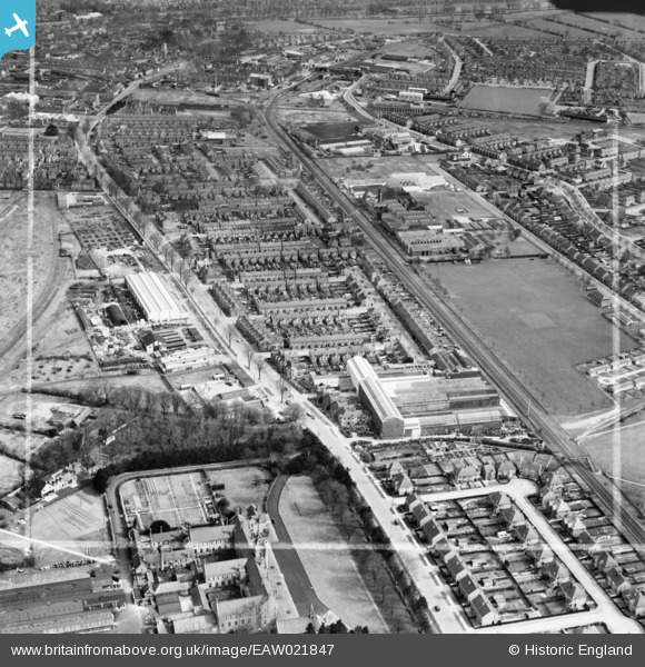
EAW021847 ENGLAND (1949). Ampthill Road, the W.H.A. Robertson & Co Ltd Lynton Engineering Works and environs, Bedford, 1949. This image was marked by Aerofilms Ltd for photo editing.
© Hawlfraint cyfranwyr OpenStreetMap a thrwyddedwyd gan yr OpenStreetMap Foundation. 2025. Trwyddedir y gartograffeg fel CC BY-SA.
Delweddau cyfagos (17)
Manylion
| Pennawd | [EAW021847] Ampthill Road, the W.H.A. Robertson & Co Ltd Lynton Engineering Works and environs, Bedford, 1949. This image was marked by Aerofilms Ltd for photo editing. |
| Cyfeirnod | EAW021847 |
| Dyddiad | 11-April-1949 |
| Dolen | |
| Enw lle | BEDFORD |
| Plwyf | |
| Ardal | |
| Gwlad | ENGLAND |
| Dwyreiniad / Gogleddiad | 504700, 248163 |
| Hydred / Lledred | -0.47055144928558, 52.12144249846 |
| Cyfeirnod Grid Cenedlaethol | TL047482 |
Pinnau
 Matt Aldred edob.mattaldred.com |
Thursday 7th of March 2024 05:30:26 PM | |
 Matt Aldred edob.mattaldred.com |
Thursday 7th of March 2024 05:29:08 PM | |
 Matt Aldred edob.mattaldred.com |
Thursday 7th of March 2024 05:27:52 PM | |
 John Wass |
Sunday 18th of September 2016 08:33:58 PM | |
 John W |
Sunday 29th of May 2016 06:26:08 PM | |
 peter |
Thursday 30th of January 2014 01:29:36 PM | |
 peter |
Thursday 30th of January 2014 01:27:33 PM | |
 peter |
Thursday 30th of January 2014 01:26:10 PM | |
 peter |
Wednesday 22nd of January 2014 07:28:46 PM | |
 peter |
Wednesday 22nd of January 2014 07:27:21 PM | |
 peter |
Sunday 19th of January 2014 01:54:15 PM | |
 peter |
Sunday 19th of January 2014 01:35:41 PM | |
 peter |
Sunday 12th of January 2014 12:53:57 PM | |
 melgibbs |
Saturday 11th of January 2014 08:21:55 PM | |
 melgibbs |
Saturday 11th of January 2014 08:20:46 PM | |
 melgibbs |
Saturday 11th of January 2014 08:20:19 PM | |
 melgibbs |
Saturday 11th of January 2014 08:19:45 PM | |
 melgibbs |
Saturday 11th of January 2014 08:18:56 PM | |
 melgibbs |
Saturday 11th of January 2014 08:18:23 PM | |
 melgibbs |
Saturday 11th of January 2014 08:17:48 PM | |
 melgibbs |
Saturday 11th of January 2014 08:15:29 PM | |
 melgibbs |
Saturday 11th of January 2014 08:14:16 PM | |
 melgibbs |
Saturday 11th of January 2014 08:13:42 PM | |
 melgibbs |
Saturday 11th of January 2014 08:12:41 PM |


![[EAW021847] Ampthill Road, the W.H.A. Robertson & Co Ltd Lynton Engineering Works and environs, Bedford, 1949. This image was marked by Aerofilms Ltd for photo editing.](http://britainfromabove.org.uk/sites/all/libraries/aerofilms-images/public/100x100/EAW/021/EAW021847.jpg)
![[EAW021842] The W.H.A. Robertson & Co Ltd Lynton Engineering Works and environs, Bedford, from the east, 1949. This image was marked by Aerofilms Ltd for photo editing.](http://britainfromabove.org.uk/sites/all/libraries/aerofilms-images/public/100x100/EAW/021/EAW021842.jpg)
![[EAW021848] The W.H.A. Robertson & Co Ltd Lynton Engineering Works and environs, Bedford, 1949. This image was marked by Aerofilms Ltd for photo editing.](http://britainfromabove.org.uk/sites/all/libraries/aerofilms-images/public/100x100/EAW/021/EAW021848.jpg)
![[EAW021843] The W.H.A. Robertson & Co Ltd Lynton Engineering Works and environs, Bedford, 1949. This image was marked by Aerofilms Ltd for photo editing.](http://britainfromabove.org.uk/sites/all/libraries/aerofilms-images/public/100x100/EAW/021/EAW021843.jpg)
![[EAW021845] The W.H.A. Robertson & Co Ltd Lynton Engineering Works and environs, Bedford, 1949. This image was marked by Aerofilms Ltd for photo editing.](http://britainfromabove.org.uk/sites/all/libraries/aerofilms-images/public/100x100/EAW/021/EAW021845.jpg)
![[EAW021849] The W.H.A. Robertson & Co Ltd Lynton Engineering Works and environs, Bedford, 1949. This image was marked by Aerofilms Ltd for photo editing.](http://britainfromabove.org.uk/sites/all/libraries/aerofilms-images/public/100x100/EAW/021/EAW021849.jpg)
![[EAW016099] The town, Bedford, from the south, 1948. This image has been produced from a print.](http://britainfromabove.org.uk/sites/all/libraries/aerofilms-images/public/100x100/EAW/016/EAW016099.jpg)
![[EAW021844] The W.H.A. Robertson & Co Ltd Lynton Engineering Works and environs, Bedford, 1949. This image was marked by Aerofilms Ltd for photo editing.](http://britainfromabove.org.uk/sites/all/libraries/aerofilms-images/public/100x100/EAW/021/EAW021844.jpg)
![[EAW021841] The W.H.A. Robertson & Co Ltd Lynton Engineering Works and environs, Bedford, 1949. This image was marked by Aerofilms Ltd for photo editing.](http://britainfromabove.org.uk/sites/all/libraries/aerofilms-images/public/100x100/EAW/021/EAW021841.jpg)
![[EAW023994] The Meltis Ltd Sweet Factory on Miller Road and adjacent recreation ground, Bedford, 1949. This image has been produced from a print marked by Aerofilms Ltd for photo editing.](http://britainfromabove.org.uk/sites/all/libraries/aerofilms-images/public/100x100/EAW/023/EAW023994.jpg)
![[EAW021840] The W.H.A. Robertson & Co Ltd Lynton Engineering Works and environs, Bedford, 1949. This image was marked by Aerofilms Ltd for photo editing.](http://britainfromabove.org.uk/sites/all/libraries/aerofilms-images/public/100x100/EAW/021/EAW021840.jpg)
![[EAW023991] The Meltis Ltd Sweet Factory on Miller Road, Bedford, 1949. This image has been produced from a print marked by Aerofilms Ltd for photo editing.](http://britainfromabove.org.uk/sites/all/libraries/aerofilms-images/public/100x100/EAW/023/EAW023991.jpg)
![[EAW023993] The Meltis Ltd Sweet Factory on Miller Road, Bedford, 1949. This image has been produced from a print.](http://britainfromabove.org.uk/sites/all/libraries/aerofilms-images/public/100x100/EAW/023/EAW023993.jpg)
![[EAW021846] The W.H.A. Robertson & Co Ltd Lynton Engineering Works and environs, Bedford, 1949. This image was marked by Aerofilms Ltd for photo editing.](http://britainfromabove.org.uk/sites/all/libraries/aerofilms-images/public/100x100/EAW/021/EAW021846.jpg)
![[EAW023987] The Meltis Ltd Sweet Factory on Miller Road, Bedford, 1949. This image has been produced from a print.](http://britainfromabove.org.uk/sites/all/libraries/aerofilms-images/public/100x100/EAW/023/EAW023987.jpg)
![[EAW023989] The Meltis Ltd Sweet Factory on Miller Road, Bedford, 1949. This image has been produced from a print marked by Aerofilms Ltd for photo editing.](http://britainfromabove.org.uk/sites/all/libraries/aerofilms-images/public/100x100/EAW/023/EAW023989.jpg)
![[EAW018299] Residential areas around the Miller Road Recreation Ground and the Cosmic Crayon Works, South End, from the south-east, 1948. This image was marked by Aerofilms Ltd for photo editing.](http://britainfromabove.org.uk/sites/all/libraries/aerofilms-images/public/100x100/EAW/018/EAW018299.jpg)