
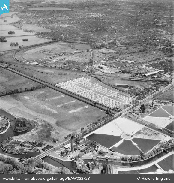
EAW022728 ENGLAND (1949). The Porters Field Estate of prefabricated houses on Lea Bridge Road and environs, Leyton, 1949
© Hawlfraint cyfranwyr OpenStreetMap a thrwyddedwyd gan yr OpenStreetMap Foundation. 2025. Trwyddedir y gartograffeg fel CC BY-SA.
Delweddau cyfagos (2)
EAW022728

EPW042089

Manylion
| Pennawd | [EAW022728] The Porters Field Estate of prefabricated houses on Lea Bridge Road and environs, Leyton, 1949 |
| Cyfeirnod | EAW022728 |
| Dyddiad | 2-May-1949 |
| Dolen | |
| Enw lle | LEYTON |
| Plwyf | |
| Ardal | |
| Gwlad | ENGLAND |
| Dwyreiniad / Gogleddiad | 535814, 187134 |
| Hydred / Lledred | -0.040269214241127, 51.566227259866 |
| Cyfeirnod Grid Cenedlaethol | TQ358871 |
Pinnau
 Carl |
Tuesday 11th of April 2023 10:01:17 AM | |
Carl |
Tuesday 11th of April 2023 10:00:21 AM | |
Carl |
Tuesday 11th of April 2023 09:59:56 AM | |
Dank |
Sunday 22nd of November 2020 04:18:36 PM | |
Dank |
Sunday 22nd of November 2020 04:17:29 PM | |
Dank |
Sunday 22nd of November 2020 04:12:16 PM | |
J |
Tuesday 20th of October 2020 05:10:59 PM | |
J |
Wednesday 22nd of July 2020 05:48:18 PM | |
J |
Wednesday 22nd of July 2020 05:46:30 AM | |
J |
Wednesday 22nd of July 2020 05:42:50 AM | |
J |
Wednesday 22nd of July 2020 05:33:58 AM | |
J |
Tuesday 21st of July 2020 05:01:43 PM | |
Sparky |
Sunday 27th of August 2017 09:26:55 PM | |
John Wass |
Saturday 4th of July 2015 03:04:00 PM | |
 8-2007.JPG) Keith |
Thursday 13th of November 2014 01:22:09 AM | |
Keith |
Thursday 13th of November 2014 01:18:35 AM | |
Keith |
Thursday 13th of November 2014 01:17:02 AM | |
Keith |
Thursday 13th of November 2014 01:15:01 AM | |
G.Martin |
Sunday 8th of June 2014 04:14:07 PM | |
Strangely, although derelict the stadium appears in better shape than photos dated 1947 ? |
gBr |
Wednesday 2nd of March 2016 08:49:13 PM |
cptpies |
Wednesday 18th of December 2013 10:47:16 AM | |
Hello cptpies, As a local historian in Waltham Forest I would like to get accuracy and references for this site on behalf of the borough museum(Vestry House, Walthamstow). I can totally agree with the appearance of the visible lay-out as a AA Battery, seeming to be 4 or 5 seperate placements around a 360 degree circle. However, the named location is not Hackney Marshes - so is it Battery ZE21? Or a different battery? The exact location by name, then and today, is Low Hall Sports ground, South Access Road.The Walthamstow Marshes are to the left of the double section railway line running NW to SE across the picture. This is definite because to the right of the battery is the Low Hall SG pavilion and cricket pitch(still there today), and to the left running round in a semi-circle is the famous 'Hall Farm Curve', a single line joining the Cambridge branch on the lower angle(from Stratford) to the Liverpool Street to Chingford line on the upper section. Can you name the source of the HAA Battery locations for London? It may also have given a location for a seperate 'Z' rocket battery which was on Hackney Marshes about a mile further south. |
Keith |
Thursday 13th of November 2014 01:10:12 AM |
That's ZE19 Walthamstow. Had two square pits of unusual design added to the four? original pits. Hackney ZE21 (both of them) is to the West. |
tiv |
Wednesday 14th of December 2016 01:32:39 PM |

Cyfraniadau Grŵp
 HAA Battery, Leyton Marshes. |
cptpies |
Thursday 19th of December 2013 02:56:10 PM |