
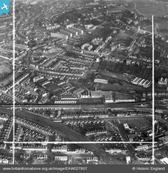
EAW027807 ENGLAND (1949). Elliott Brothers (London) Ltd Century Works (Electrical Engineering), Lewisham, 1949. This image has been produced from a print marked by Aerofilms Ltd for photo editing.
© Hawlfraint cyfranwyr OpenStreetMap a thrwyddedwyd gan yr OpenStreetMap Foundation. 2025. Trwyddedir y gartograffeg fel CC BY-SA.
Delweddau cyfagos (7)
EAW027807
 Ltd Century Works (Electrical Engineering), Lewisham, 1949. This image has been produced from a print marked by Aerofilms Ltd for photo editing.")
EAW027809
 Ltd Century Works (Electrical Engineering), Lewisham, 1949. This image was marked by Aerofilms Ltd for photo editing.")
EAW027808
 Ltd Century Works (Electrical Engineering), Lewisham, 1949. This image has been produced from a print marked by Aerofilms Ltd for photo editing.")
EAW027806
 Ltd Century Works (Electrical Engineering), Lewisham, 1949. This image has been produced from a print marked by Aerofilms Ltd for photo editing.")
EAW027803
 Ltd Century Works (Electrical Engineering), Lewisham, 1949. This image was marked by Aerofilms Ltd for photo editing.")
EAW027805
 Ltd Century Works (Electrical Engineering), Lewisham, 1949. This image has been produced from a print marked by Aerofilms Ltd for photo editing.")
EAW027804
 Ltd Century Works (Electrical Engineering), Lewisham, 1949. This image has been produced from a damaged negative.")
Manylion
| Pennawd | [EAW027807] Elliott Brothers (London) Ltd Century Works (Electrical Engineering), Lewisham, 1949. This image has been produced from a print marked by Aerofilms Ltd for photo editing. |
| Cyfeirnod | EAW027807 |
| Dyddiad | 19-December-1949 |
| Dolen | |
| Enw lle | LEWISHAM |
| Plwyf | |
| Ardal | |
| Gwlad | ENGLAND |
| Dwyreiniad / Gogleddiad | 537959, 176176 |
| Hydred / Lledred | -0.013627811128936, 51.467226273748 |
| Cyfeirnod Grid Cenedlaethol | TQ380762 |
Pinnau
 Post-war prefabs |
Monday 20th of March 2023 11:57:10 AM | |
Leslie B |
Saturday 3rd of December 2022 12:34:28 PM | |
Leslie B |
Friday 2nd of June 2017 09:35:22 PM | |
John Wass |
Friday 26th of June 2015 08:35:55 PM |