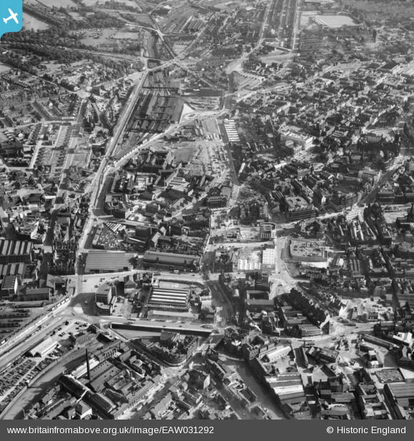
EAW031292 ENGLAND (1950). The city centre, Sheffield, 1950
© Hawlfraint cyfranwyr OpenStreetMap a thrwyddedwyd gan yr OpenStreetMap Foundation. 2025. Trwyddedir y gartograffeg fel CC BY-SA.
Delweddau cyfagos (18)
Manylion
| Pennawd | [EAW031292] The city centre, Sheffield, 1950 |
| Cyfeirnod | EAW031292 |
| Dyddiad | 26-July-1950 |
| Dolen | |
| Enw lle | SHEFFIELD |
| Plwyf | |
| Ardal | |
| Gwlad | ENGLAND |
| Dwyreiniad / Gogleddiad | 435742, 387429 |
| Hydred / Lledred | -1.462603014547, 53.382234868379 |
| Cyfeirnod Grid Cenedlaethol | SK357874 |
Pinnau
 Railway Man |
Tuesday 12th of May 2020 11:29:03 AM | |
 Class31 |
Wednesday 22nd of July 2015 11:08:07 PM | |
 RichardL |
Thursday 1st of January 2015 05:45:41 PM | |
 gBr |
Wednesday 31st of December 2014 06:03:41 PM | |
 travellingpass |
Wednesday 31st of December 2014 10:36:38 AM | |
 travellingpass |
Wednesday 31st of December 2014 10:33:06 AM |


![[EAW031292] The city centre, Sheffield, 1950](http://britainfromabove.org.uk/sites/all/libraries/aerofilms-images/public/100x100/EAW/031/EAW031292.jpg)
![[EPW055239] Fitzalan Square and environs, Sheffield, 1937](http://britainfromabove.org.uk/sites/all/libraries/aerofilms-images/public/100x100/EPW/055/EPW055239.jpg)
![[EPW055243] Fitzalan Square and environs, Sheffield, 1937](http://britainfromabove.org.uk/sites/all/libraries/aerofilms-images/public/100x100/EPW/055/EPW055243.jpg)
![[EAW042504] Fitzalan Square and the city centre, Sheffield, 1952](http://britainfromabove.org.uk/sites/all/libraries/aerofilms-images/public/100x100/EAW/042/EAW042504.jpg)
![[EPW055236] The city centre, Sheffield, 1937](http://britainfromabove.org.uk/sites/all/libraries/aerofilms-images/public/100x100/EPW/055/EPW055236.jpg)
![[EPW021136] Fitzalan Square and environs, Sheffield, 1928](http://britainfromabove.org.uk/sites/all/libraries/aerofilms-images/public/100x100/EPW/021/EPW021136.jpg)
![[EPW055232] Fitzalan Square and environs, Sheffield, 1937](http://britainfromabove.org.uk/sites/all/libraries/aerofilms-images/public/100x100/EPW/055/EPW055232.jpg)
![[EPW021137] The Town Centre, Sheffield, 1928](http://britainfromabove.org.uk/sites/all/libraries/aerofilms-images/public/100x100/EPW/021/EPW021137.jpg)
![[EPW021138] Fitzalan Square and environs, Sheffield, 1928](http://britainfromabove.org.uk/sites/all/libraries/aerofilms-images/public/100x100/EPW/021/EPW021138.jpg)
![[EPW055241] Norfolk Market Hall and environs, Sheffield, 1937](http://britainfromabove.org.uk/sites/all/libraries/aerofilms-images/public/100x100/EPW/055/EPW055241.jpg)
![[EPW055249] High Street and environs, Sheffield, 1937](http://britainfromabove.org.uk/sites/all/libraries/aerofilms-images/public/100x100/EPW/055/EPW055249.jpg)
![[EPW041621] The Castle Market, Exchange Street and the city centre, Sheffield, 1933](http://britainfromabove.org.uk/sites/all/libraries/aerofilms-images/public/100x100/EPW/041/EPW041621.jpg)
![[EAW042503] The city centre, Sheffield, 1952](http://britainfromabove.org.uk/sites/all/libraries/aerofilms-images/public/100x100/EAW/042/EAW042503.jpg)
![[EPW005965] Haymarket, the site of Sheffield Castle and the Norfolk Market Hall, Sheffield, 1921. This image has been produced from a copy-negative.](http://britainfromabove.org.uk/sites/all/libraries/aerofilms-images/public/100x100/EPW/005/EPW005965.jpg)
![[EPW055248] Campo Lane and environs, Sheffield, 1937](http://britainfromabove.org.uk/sites/all/libraries/aerofilms-images/public/100x100/EPW/055/EPW055248.jpg)
![[EPW055240] Castle Hill Market, Sheffield, 1937](http://britainfromabove.org.uk/sites/all/libraries/aerofilms-images/public/100x100/EPW/055/EPW055240.jpg)
![[EPW015466] High Street, Sheffield, 1926](http://britainfromabove.org.uk/sites/all/libraries/aerofilms-images/public/100x100/EPW/015/EPW015466.jpg)
![[EPW055234] Campo Lane and environs, Sheffield, 1937](http://britainfromabove.org.uk/sites/all/libraries/aerofilms-images/public/100x100/EPW/055/EPW055234.jpg)