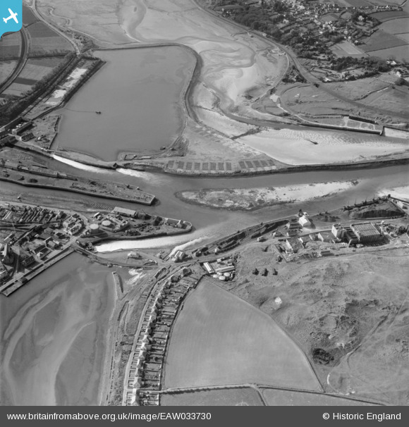
EAW033730 ENGLAND (1950). The harbour, Hayle, 1950
© Hawlfraint cyfranwyr OpenStreetMap a thrwyddedwyd gan yr OpenStreetMap Foundation. 2024. Trwyddedir y gartograffeg fel CC BY-SA.
Delweddau cyfagos (21)
Manylion
| Pennawd | [EAW033730] The harbour, Hayle, 1950 |
| Cyfeirnod | EAW033730 |
| Dyddiad | 16-October-1950 |
| Dolen | |
| Enw lle | HAYLE |
| Plwyf | HAYLE |
| Ardal | |
| Gwlad | ENGLAND |
| Dwyreiniad / Gogleddiad | 155572, 37684 |
| Hydred / Lledred | -5.424670160368, 50.188026799594 |
| Cyfeirnod Grid Cenedlaethol | SW556377 |
Pinnau
 redmist |
Wednesday 15th of July 2020 01:02:56 PM | |
 redmist |
Wednesday 15th of July 2020 01:01:56 PM | |
 redmist |
Wednesday 15th of July 2020 01:01:32 PM | |
 redmist |
Wednesday 15th of July 2020 01:01:00 PM | |
 redmist |
Wednesday 15th of July 2020 01:00:11 PM | |
 redmist |
Wednesday 15th of July 2020 12:57:57 PM | |
 Kevin |
Tuesday 17th of September 2019 04:02:07 PM |


![[EAW033730] The harbour, Hayle, 1950](http://britainfromabove.org.uk/sites/all/libraries/aerofilms-images/public/100x100/EAW/033/EAW033730.jpg)
![[EAW033731] The Associated Ethyl Co Ltd Works at Hayle Harbour, Hayle, 1950. This image was marked by Aerofilms Ltd for photo editing.](http://britainfromabove.org.uk/sites/all/libraries/aerofilms-images/public/100x100/EAW/033/EAW033731.jpg)
![[EAW033735] The Associated Ethyl Co Ltd Works at Hayle Harbour, Hayle, 1950](http://britainfromabove.org.uk/sites/all/libraries/aerofilms-images/public/100x100/EAW/033/EAW033735.jpg)
![[EAW030942] Carnsew Pool and environs, Hayle, 1950. This image was marked by Aerofilms Ltd for photo editing.](http://britainfromabove.org.uk/sites/all/libraries/aerofilms-images/public/100x100/EAW/030/EAW030942.jpg)
![[EAW030936] Hayle estuary and the town, Hayle, 1950. This image was marked by Aerofilms Ltd for photo editing.](http://britainfromabove.org.uk/sites/all/libraries/aerofilms-images/public/100x100/EAW/030/EAW030936.jpg)
![[EAW033734] The Associated Ethyl Co Ltd Works at Hayle Harbour and the Riviere Estate Chalet Camp, Hayle, 1950. This image was marked by Aerofilms Ltd for photo editing.](http://britainfromabove.org.uk/sites/all/libraries/aerofilms-images/public/100x100/EAW/033/EAW033734.jpg)
![[EAW033739] The Associated Ethyl Co Ltd Works at Hayle Harbour, Hayle, 1950](http://britainfromabove.org.uk/sites/all/libraries/aerofilms-images/public/100x100/EAW/033/EAW033739.jpg)
![[EAW007752] Imperial Chemical Industries British Ethyl Works at North Quay, Hayle, 1947](http://britainfromabove.org.uk/sites/all/libraries/aerofilms-images/public/100x100/EAW/007/EAW007752.jpg)
![[EAW033733] The Associated Ethyl Co Ltd Works at Hayle Harbour, Hayle, 1950. This image was marked by Aerofilms Ltd for photo editing.](http://britainfromabove.org.uk/sites/all/libraries/aerofilms-images/public/100x100/EAW/033/EAW033733.jpg)
![[EAW033732] The Associated Ethyl Co Ltd Works at Hayle Harbour, Hayle, 1950. This image was marked by Aerofilms Ltd for photo editing.](http://britainfromabove.org.uk/sites/all/libraries/aerofilms-images/public/100x100/EAW/033/EAW033732.jpg)
![[EAW033741] The Associated Ethyl Co Ltd Works at Hayle Harbour, Hayle, 1950](http://britainfromabove.org.uk/sites/all/libraries/aerofilms-images/public/100x100/EAW/033/EAW033741.jpg)
![[EAW033737] The Associated Ethyl Co Ltd Works at Hayle Harbour and the Riviere Estate Chalet Camp, Hayle, 1950](http://britainfromabove.org.uk/sites/all/libraries/aerofilms-images/public/100x100/EAW/033/EAW033737.jpg)
![[EAW007760] Imperial Chemical Industries British Ethyl Works at North Quay, Hayle, 1947](http://britainfromabove.org.uk/sites/all/libraries/aerofilms-images/public/100x100/EAW/007/EAW007760.jpg)
![[EPW059856] The harbour, quayside and Carnsew Pond, Hayle, 1938. This image has been produced from a damaged negative.](http://britainfromabove.org.uk/sites/all/libraries/aerofilms-images/public/100x100/EPW/059/EPW059856.jpg)
![[EAW030935] Hayle estuary and the town, Hayle, 1950. This image was marked by Aerofilms Ltd for photo editing.](http://britainfromabove.org.uk/sites/all/libraries/aerofilms-images/public/100x100/EAW/030/EAW030935.jpg)
![[EAW033738] The Associated Ethyl Co Ltd Works at Hayle Harbour, Hayle, 1950. This image was marked by Aerofilms Ltd for photo editing.](http://britainfromabove.org.uk/sites/all/libraries/aerofilms-images/public/100x100/EAW/033/EAW033738.jpg)
![[EAW007761] Imperial Chemical Industries British Ethyl Works at North Quay, Hayle, 1947](http://britainfromabove.org.uk/sites/all/libraries/aerofilms-images/public/100x100/EAW/007/EAW007761.jpg)
![[EAW033740] The Associated Ethyl Co Ltd Works at Hayle Harbour, Hayle, 1950. This image was marked by Aerofilms Ltd for photo editing.](http://britainfromabove.org.uk/sites/all/libraries/aerofilms-images/public/100x100/EAW/033/EAW033740.jpg)
![[EAW007753] Imperial Chemical Industries British Ethyl Works at North Quay, Hayle, 1947](http://britainfromabove.org.uk/sites/all/libraries/aerofilms-images/public/100x100/EAW/007/EAW007753.jpg)
![[EAW007758] Imperial Chemical Industries British Ethyl Works at North Quay, Hayle, 1947](http://britainfromabove.org.uk/sites/all/libraries/aerofilms-images/public/100x100/EAW/007/EAW007758.jpg)
![[EAW033736] The Associated Ethyl Co Ltd Works at Hayle Harbour, Hayle, 1950](http://britainfromabove.org.uk/sites/all/libraries/aerofilms-images/public/100x100/EAW/033/EAW033736.jpg)