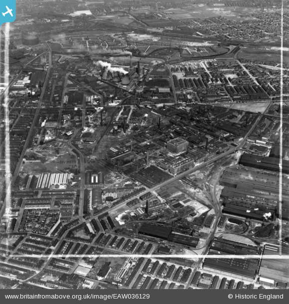
EAW036129 ENGLAND (1951). The Clayton Aniline Chemical Works and environs, Manchester, 1951. This image has been produced from a print marked by Aerofilms Ltd for photo editing.
© Hawlfraint cyfranwyr OpenStreetMap a thrwyddedwyd gan yr OpenStreetMap Foundation. 2025. Trwyddedir y gartograffeg fel CC BY-SA.
Delweddau cyfagos (11)
Manylion
| Pennawd | [EAW036129] The Clayton Aniline Chemical Works and environs, Manchester, 1951. This image has been produced from a print marked by Aerofilms Ltd for photo editing. |
| Cyfeirnod | EAW036129 |
| Dyddiad | 17-May-1951 |
| Dolen | |
| Enw lle | MANCHESTER |
| Plwyf | |
| Ardal | |
| Gwlad | ENGLAND |
| Dwyreiniad / Gogleddiad | 387601, 398156 |
| Hydred / Lledred | -2.1868509207843, 53.479729313894 |
| Cyfeirnod Grid Cenedlaethol | SJ876982 |
Pinnau
 indiern |
Thursday 7th of December 2023 05:41:54 PM | |
 indiern |
Thursday 7th of December 2023 05:38:04 PM | |
 indiern |
Thursday 7th of December 2023 05:34:31 PM | |
 indiern |
Thursday 7th of December 2023 05:23:48 PM | |
 indiern |
Thursday 7th of December 2023 05:21:16 PM | |
 redmist |
Saturday 10th of October 2020 12:12:00 PM | |
 stardelta |
Saturday 3rd of January 2015 07:56:43 PM | |
 Barney Rubble |
Monday 1st of December 2014 05:14:20 PM |


![[EAW036129] The Clayton Aniline Chemical Works and environs, Manchester, 1951. This image has been produced from a print marked by Aerofilms Ltd for photo editing.](http://britainfromabove.org.uk/sites/all/libraries/aerofilms-images/public/100x100/EAW/036/EAW036129.jpg)
![[EAW036138] The Clayton Aniline Chemical Works and environs, Manchester, 1951. This image has been produced from a print marked by Aerofilms Ltd for photo editing.](http://britainfromabove.org.uk/sites/all/libraries/aerofilms-images/public/100x100/EAW/036/EAW036138.jpg)
![[EAW036130] The Clayton Aniline Chemical Works and environs, Manchester, 1951. This image has been produced from a print marked by Aerofilms Ltd for photo editing.](http://britainfromabove.org.uk/sites/all/libraries/aerofilms-images/public/100x100/EAW/036/EAW036130.jpg)
![[EAW036135] The Clayton Aniline Chemical Works and environs, Manchester, 1951. This image has been produced from a print marked by Aerofilms Ltd for photo editing.](http://britainfromabove.org.uk/sites/all/libraries/aerofilms-images/public/100x100/EAW/036/EAW036135.jpg)
![[EAW036137] The Clayton Aniline Chemical Works and environs, Manchester, 1951. This image has been produced from a print marked by Aerofilms Ltd for photo editing.](http://britainfromabove.org.uk/sites/all/libraries/aerofilms-images/public/100x100/EAW/036/EAW036137.jpg)
![[EAW036134] The Clayton Aniline Chemical Works and environs, Manchester, 1951. This image has been produced from a print marked by Aerofilms Ltd for photo editing.](http://britainfromabove.org.uk/sites/all/libraries/aerofilms-images/public/100x100/EAW/036/EAW036134.jpg)
![[EAW036131] The Clayton Aniline Chemical Works and environs, Manchester, 1951. This image has been produced from a print marked by Aerofilms Ltd for photo editing.](http://britainfromabove.org.uk/sites/all/libraries/aerofilms-images/public/100x100/EAW/036/EAW036131.jpg)
![[EAW036133] The Clayton Aniline Chemical Works and environs, Manchester, 1951. This image has been produced from a print marked by Aerofilms Ltd for photo editing.](http://britainfromabove.org.uk/sites/all/libraries/aerofilms-images/public/100x100/EAW/036/EAW036133.jpg)
![[EAW036132] The Clayton Aniline Chemical Works and environs, Manchester, 1951. This image has been produced from a print marked by Aerofilms Ltd for photo editing.](http://britainfromabove.org.uk/sites/all/libraries/aerofilms-images/public/100x100/EAW/036/EAW036132.jpg)
![[EAW036136] The Clayton Aniline Chemical Works and environs, Manchester, from the south-east, 1951. This image has been produced from a print marked by Aerofilms Ltd for photo editing.](http://britainfromabove.org.uk/sites/all/libraries/aerofilms-images/public/100x100/EAW/036/EAW036136.jpg)
![[EAW022088] The English Steel Corporation North Street Works, Openshaw, 1949](http://britainfromabove.org.uk/sites/all/libraries/aerofilms-images/public/100x100/EAW/022/EAW022088.jpg)