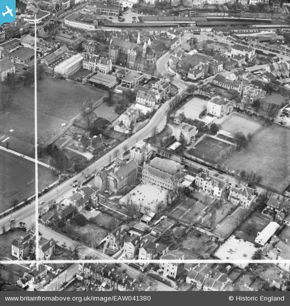
EAW041380 ENGLAND (1951). Croydon High School for Girls, Croydon, 1951. This image was marked by Aerofilms Ltd for photo editing.
© Hawlfraint cyfranwyr OpenStreetMap a thrwyddedwyd gan yr OpenStreetMap Foundation. 2025. Trwyddedir y gartograffeg fel CC BY-SA.
Delweddau cyfagos (20)
Manylion
| Pennawd | [EAW041380] Croydon High School for Girls, Croydon, 1951. This image was marked by Aerofilms Ltd for photo editing. |
| Cyfeirnod | EAW041380 |
| Dyddiad | 22-November-1951 |
| Dolen | |
| Enw lle | CROYDON |
| Plwyf | |
| Ardal | |
| Gwlad | ENGLAND |
| Dwyreiniad / Gogleddiad | 532424, 165984 |
| Hydred / Lledred | -0.097083264102319, 51.376946674819 |
| Cyfeirnod Grid Cenedlaethol | TQ324660 |
Pinnau
 Breweryman |
Sunday 27th of February 2022 08:26:29 PM | |
 brianbeckett |
Wednesday 24th of September 2014 02:40:38 PM | |
 brianbeckett |
Wednesday 24th of September 2014 02:39:41 PM |
Cyfraniadau Grŵp
Croydon High School had three adjoining sites. South of Sydenham Road was the Senior School, with one building along Sydenham Road and another along Wellesley Road, with a playgound in between. (A Science block was added before I started aged 11 in about 1963, and another building nearer to Lansdowne Road was used by the 6th form and known as "The House". The other side of Sydenham Road was the playing field, behind the Junior School "The Homestead", and the Infants School "The Elms", I understand that these premises were previously market gardens. The other side of Wellesley Road is a house which was part of the Trinity (Whitgift Middle) School. |
 OldieDi |
Monday 22nd of February 2016 11:07:58 AM |


![[EAW041380] Croydon High School for Girls, Croydon, 1951. This image was marked by Aerofilms Ltd for photo editing.](http://britainfromabove.org.uk/sites/all/libraries/aerofilms-images/public/100x100/EAW/041/EAW041380.jpg)
![[EAW041379] Croydon High School for Girls, Croydon, 1951. This image has been produced from a print marked by Aerofilms Ltd for photo editing.](http://britainfromabove.org.uk/sites/all/libraries/aerofilms-images/public/100x100/EAW/041/EAW041379.jpg)
![[EAW042967] Croydon High School for Girls at the junction of Wellesley Road and Sydenham Road, Croydon, 1952. This image was marked by Aerofilms Ltd for photo editing.](http://britainfromabove.org.uk/sites/all/libraries/aerofilms-images/public/100x100/EAW/042/EAW042967.jpg)
![[EAW041377] Croydon High School for Girls, Croydon, 1951. This image has been produced from a print marked by Aerofilms Ltd for photo editing.](http://britainfromabove.org.uk/sites/all/libraries/aerofilms-images/public/100x100/EAW/041/EAW041377.jpg)
![[EAW041378] Croydon High School for Girls, Croydon, 1951. This image has been produced from a print marked by Aerofilms Ltd for photo editing.](http://britainfromabove.org.uk/sites/all/libraries/aerofilms-images/public/100x100/EAW/041/EAW041378.jpg)
![[EAW042972] Croydon High School for Girls and Wellesley Road, Croydon, 1952. This image was marked by Aerofilms Ltd for photo editing.](http://britainfromabove.org.uk/sites/all/libraries/aerofilms-images/public/100x100/EAW/042/EAW042972.jpg)
![[EAW041382] Croydon High School for Girls, Croydon, 1951. This image has been produced from a print marked by Aerofilms Ltd for photo editing.](http://britainfromabove.org.uk/sites/all/libraries/aerofilms-images/public/100x100/EAW/041/EAW041382.jpg)
![[EAW042964] Croydon High School for Girls at the junction of Wellesley Road and Sydenham Road, Croydon, 1952. This image was marked by Aerofilms Ltd for photo editing.](http://britainfromabove.org.uk/sites/all/libraries/aerofilms-images/public/100x100/EAW/042/EAW042964.jpg)
![[EAW042970] Croydon High School for Girls, Sydenham Road and environs, Croydon, 1952. This image was marked by Aerofilms Ltd for photo editing.](http://britainfromabove.org.uk/sites/all/libraries/aerofilms-images/public/100x100/EAW/042/EAW042970.jpg)
![[EAW042971] Croydon High School for Girls at the junction of Wellesley Road and Sydenham Road, Croydon, 1952. This image was marked by Aerofilms Ltd for photo editing.](http://britainfromabove.org.uk/sites/all/libraries/aerofilms-images/public/100x100/EAW/042/EAW042971.jpg)
![[EAW041376] Croydon High School for Girls, Croydon, 1951. This image has been produced from a print marked by Aerofilms Ltd for photo editing.](http://britainfromabove.org.uk/sites/all/libraries/aerofilms-images/public/100x100/EAW/041/EAW041376.jpg)
![[EAW042969] Croydon High School for Girls at the junction of Wellesley Road and Sydenham Road, Croydon, 1952. This image was marked by Aerofilms Ltd for photo editing.](http://britainfromabove.org.uk/sites/all/libraries/aerofilms-images/public/100x100/EAW/042/EAW042969.jpg)
![[EAW041381] Croydon High School for Girls, Croydon, 1951. This image has been produced from a print marked by Aerofilms Ltd for photo editing.](http://britainfromabove.org.uk/sites/all/libraries/aerofilms-images/public/100x100/EAW/041/EAW041381.jpg)
![[EAW042973] Croydon High School for Girls at the junction of Wellesley Road and Sydenham Road and environs, Croydon, 1952. This image was marked by Aerofilms Ltd for photo editing.](http://britainfromabove.org.uk/sites/all/libraries/aerofilms-images/public/100x100/EAW/042/EAW042973.jpg)
![[EAW042968] Croydon High School for Girls at the junction of Wellesley Road and Sydenham Road, Croydon, 1952. This image was marked by Aerofilms Ltd for photo editing.](http://britainfromabove.org.uk/sites/all/libraries/aerofilms-images/public/100x100/EAW/042/EAW042968.jpg)
![[EAW042966] Croydon High School for Girls at the junction of Wellesley Road and Sydenham Road and environs, Croydon, 1952. This image was marked by Aerofilms Ltd for photo editing.](http://britainfromabove.org.uk/sites/all/libraries/aerofilms-images/public/100x100/EAW/042/EAW042966.jpg)
![[EAW041383] Croydon High School for Girls, Croydon, 1951. This image has been produced from a print marked by Aerofilms Ltd for photo editing.](http://britainfromabove.org.uk/sites/all/libraries/aerofilms-images/public/100x100/EAW/041/EAW041383.jpg)
![[EAW042965] Croydon High School for Girls at the junction of Wellesley Road and Sydenham Road and environs, Croydon, 1952. This image was marked by Aerofilms Ltd for photo editing.](http://britainfromabove.org.uk/sites/all/libraries/aerofilms-images/public/100x100/EAW/042/EAW042965.jpg)
![[EAW047594] East Croydon Railway Station and environs, Croydon, 1952](http://britainfromabove.org.uk/sites/all/libraries/aerofilms-images/public/100x100/EAW/047/EAW047594.jpg)
![[EPW056621] St Michael and All Angels' Church and the town centre, Croydon, 1938](http://britainfromabove.org.uk/sites/all/libraries/aerofilms-images/public/100x100/EPW/056/EPW056621.jpg)