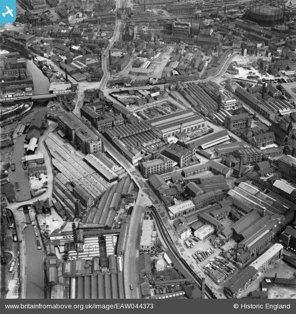
EAW044373 ENGLAND (1952). Industrial buildings around Water Lane, Leeds, 1952
© Hawlfraint cyfranwyr OpenStreetMap a thrwyddedwyd gan yr OpenStreetMap Foundation. 2025. Trwyddedir y gartograffeg fel CC BY-SA.
Delweddau cyfagos (14)
Manylion
| Pennawd | [EAW044373] Industrial buildings around Water Lane, Leeds, 1952 |
| Cyfeirnod | EAW044373 |
| Dyddiad | 27-June-1952 |
| Dolen | |
| Enw lle | LEEDS |
| Plwyf | |
| Ardal | |
| Gwlad | ENGLAND |
| Dwyreiniad / Gogleddiad | 429747, 432895 |
| Hydred / Lledred | -1.5484011478194, 53.791302881037 |
| Cyfeirnod Grid Cenedlaethol | SE297329 |


![[EAW044373] Industrial buildings around Water Lane, Leeds, 1952](http://britainfromabove.org.uk/sites/all/libraries/aerofilms-images/public/100x100/EAW/044/EAW044373.jpg)
![[EAW044372] Industrial buildings around Water Lane, Leeds, 1952](http://britainfromabove.org.uk/sites/all/libraries/aerofilms-images/public/100x100/EAW/044/EAW044372.jpg)
![[EPW050097] The R. W. Crabtree and Sons Print Machinery Manufactory and surrounding works, Leeds, 1936](http://britainfromabove.org.uk/sites/all/libraries/aerofilms-images/public/100x100/EPW/050/EPW050097.jpg)
![[EAW044371] Industrial buildings around Water Lane looking towards Whitehall Junction, Leeds, 1952](http://britainfromabove.org.uk/sites/all/libraries/aerofilms-images/public/100x100/EAW/044/EAW044371.jpg)
![[EAW044376] Industrial buildings around Water Lane, Leeds, 1952](http://britainfromabove.org.uk/sites/all/libraries/aerofilms-images/public/100x100/EAW/044/EAW044376.jpg)
![[EAW044370] Industrial buildings around Water Lane, Leeds, 1952](http://britainfromabove.org.uk/sites/all/libraries/aerofilms-images/public/100x100/EAW/044/EAW044370.jpg)
![[EPW050093] The R. W. Crabtree and Sons Print Machinery Manufactory, Canal Wharf and surrounding works, Leeds, 1936](http://britainfromabove.org.uk/sites/all/libraries/aerofilms-images/public/100x100/EPW/050/EPW050093.jpg)
![[EPW050092] The R. W. Crabtree and Sons Print Machinery Manufactory and surrounding works, Leeds, 1936](http://britainfromabove.org.uk/sites/all/libraries/aerofilms-images/public/100x100/EPW/050/EPW050092.jpg)
![[EPW050094] The R. W. Crabtree and Sons Print Machinery Manufactory, Canal Wharf and surrounding works, Leeds, 1936](http://britainfromabove.org.uk/sites/all/libraries/aerofilms-images/public/100x100/EPW/050/EPW050094.jpg)
![[EPW050095] The R. W. Crabtree and Sons Print Machinery Manufactory, Canal Wharf and surrounding works, Leeds, 1936](http://britainfromabove.org.uk/sites/all/libraries/aerofilms-images/public/100x100/EPW/050/EPW050095.jpg)
![[EAW044374] Industrial buildings around Water Lane and Camp Field, Leeds, 1952](http://britainfromabove.org.uk/sites/all/libraries/aerofilms-images/public/100x100/EAW/044/EAW044374.jpg)
![[EPW050096] The R. W. Crabtree and Sons Print Machinery Manufactory and surrounding works, Leeds, 1936](http://britainfromabove.org.uk/sites/all/libraries/aerofilms-images/public/100x100/EPW/050/EPW050096.jpg)
![[EPW050098] The R. W. Crabtree and Sons Print Machinery Manufactory and environs, Leeds, 1936](http://britainfromabove.org.uk/sites/all/libraries/aerofilms-images/public/100x100/EPW/050/EPW050098.jpg)
![[EAW044375] St Barnabas Garth, Camp Field and environs, Leeds, 1952](http://britainfromabove.org.uk/sites/all/libraries/aerofilms-images/public/100x100/EAW/044/EAW044375.jpg)
