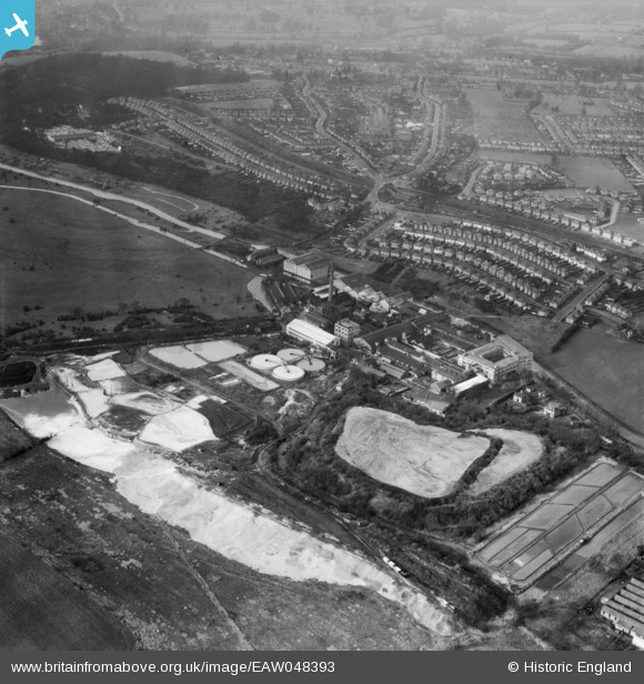
EAW048393 ENGLAND (1953). Croxley Paper Mills and environs, Croxley Green, 1953
© Hawlfraint cyfranwyr OpenStreetMap a thrwyddedwyd gan yr OpenStreetMap Foundation. 2025. Trwyddedir y gartograffeg fel CC BY-SA.
Delweddau cyfagos (21)
Manylion
| Pennawd | [EAW048393] Croxley Paper Mills and environs, Croxley Green, 1953 |
| Cyfeirnod | EAW048393 |
| Dyddiad | 5-February-1953 |
| Dolen | |
| Enw lle | CROXLEY GREEN |
| Plwyf | CROXLEY GREEN |
| Ardal | |
| Gwlad | ENGLAND |
| Dwyreiniad / Gogleddiad | 508410, 195309 |
| Hydred / Lledred | -0.4329885033401, 51.645648163709 |
| Cyfeirnod Grid Cenedlaethol | TQ084953 |
Pinnau
 Class31 |
Monday 21st of March 2016 11:40:53 AM | |
 The Laird |
Thursday 21st of May 2015 10:10:20 PM | |
 The Laird |
Thursday 21st of May 2015 08:20:43 PM | |
 The Laird |
Thursday 21st of May 2015 08:17:17 PM | |
 The Laird |
Thursday 21st of May 2015 01:04:00 PM |
Cyfraniadau Grŵp
The Red House PH, Croxley Green 26/05/2014 |
 Class31 |
Monday 21st of March 2016 11:42:15 AM |
Wonderful to see an aerial view of the house where I grew up in Winton Drive in the 1950's. |
 francisjon |
Sunday 20th of March 2016 08:23:51 PM |


![[EAW048393] Croxley Paper Mills and environs, Croxley Green, 1953](http://britainfromabove.org.uk/sites/all/libraries/aerofilms-images/public/100x100/EAW/048/EAW048393.jpg)
![[EAW048391] Croxley Paper Mills and the Grand Union Canal, Croxley Green, 1953](http://britainfromabove.org.uk/sites/all/libraries/aerofilms-images/public/100x100/EAW/048/EAW048391.jpg)
![[EAW048396] Croxley Paper Mills and the Grand Union Canal, Croxley Green, 1953](http://britainfromabove.org.uk/sites/all/libraries/aerofilms-images/public/100x100/EAW/048/EAW048396.jpg)
![[EAW048397] Croxley Paper Mills, the Grand Union Canal and environs, Croxley Green, 1953](http://britainfromabove.org.uk/sites/all/libraries/aerofilms-images/public/100x100/EAW/048/EAW048397.jpg)
![[EPW015996] The Croxley Paper Mills, Croxley Green, 1926](http://britainfromabove.org.uk/sites/all/libraries/aerofilms-images/public/100x100/EPW/015/EPW015996.jpg)
![[EPW015998] The Croxley Paper Mills, Croxley Green, 1926](http://britainfromabove.org.uk/sites/all/libraries/aerofilms-images/public/100x100/EPW/015/EPW015998.jpg)
![[EPW039596] The Croxley Paper Mills, Croxley Green, 1932](http://britainfromabove.org.uk/sites/all/libraries/aerofilms-images/public/100x100/EPW/039/EPW039596.jpg)
![[EPW039592] The Croxley Paper Mills, Croxley Green, 1932](http://britainfromabove.org.uk/sites/all/libraries/aerofilms-images/public/100x100/EPW/039/EPW039592.jpg)
![[EAW048395] Croxley Paper Mills and the Grand Union Canal, Croxley Green, 1953](http://britainfromabove.org.uk/sites/all/libraries/aerofilms-images/public/100x100/EAW/048/EAW048395.jpg)
![[EAW048394] Croxley Paper Mills and environs, Croxley Green, 1953](http://britainfromabove.org.uk/sites/all/libraries/aerofilms-images/public/100x100/EAW/048/EAW048394.jpg)
![[EPW039595] The Croxley Paper Mills, Croxley Green, 1932](http://britainfromabove.org.uk/sites/all/libraries/aerofilms-images/public/100x100/EPW/039/EPW039595.jpg)
![[EPW039590] The Croxley Paper Mills, Croxley Green, 1932](http://britainfromabove.org.uk/sites/all/libraries/aerofilms-images/public/100x100/EPW/039/EPW039590.jpg)
![[EPW039591] The Croxley Paper Mills, Croxley Green, 1932](http://britainfromabove.org.uk/sites/all/libraries/aerofilms-images/public/100x100/EPW/039/EPW039591.jpg)
![[EPW039593] The Croxley Paper Mills, Croxley Green, 1932](http://britainfromabove.org.uk/sites/all/libraries/aerofilms-images/public/100x100/EPW/039/EPW039593.jpg)
![[EPW039594] The Croxley Paper Mills and environs, Croxley Green, 1932](http://britainfromabove.org.uk/sites/all/libraries/aerofilms-images/public/100x100/EPW/039/EPW039594.jpg)
![[EPW039597] The Croxley Paper Mills, Croxley Green, 1932](http://britainfromabove.org.uk/sites/all/libraries/aerofilms-images/public/100x100/EPW/039/EPW039597.jpg)
![[EPW015995] The Croxley Paper Mills, Croxley Green, 1926](http://britainfromabove.org.uk/sites/all/libraries/aerofilms-images/public/100x100/EPW/015/EPW015995.jpg)
![[EPW019275] The Croxley Paper Mills, Croxley Green, 1927](http://britainfromabove.org.uk/sites/all/libraries/aerofilms-images/public/100x100/EPW/019/EPW019275.jpg)
![[EPW019274] The Croxley Paper Mills, Croxley Green, 1927](http://britainfromabove.org.uk/sites/all/libraries/aerofilms-images/public/100x100/EPW/019/EPW019274.jpg)
![[EPW015997] The Croxley Paper Mills, Croxley Green, 1926](http://britainfromabove.org.uk/sites/all/libraries/aerofilms-images/public/100x100/EPW/015/EPW015997.jpg)
![[EAW048392] Croxley Paper Mills and environs, Croxley Green, 1953](http://britainfromabove.org.uk/sites/all/libraries/aerofilms-images/public/100x100/EAW/048/EAW048392.jpg)