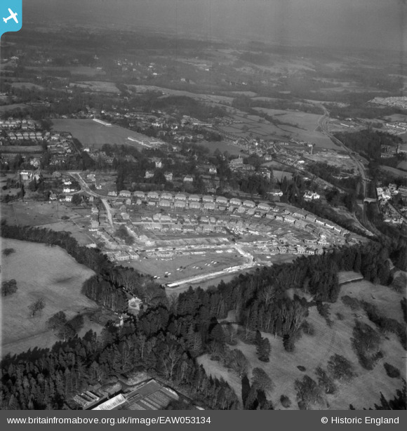
EAW053134 ENGLAND (1954). Housing under construction around Linden Avenue and environs, East Grinstead, from the south-west, 1954
© Hawlfraint cyfranwyr OpenStreetMap a thrwyddedwyd gan yr OpenStreetMap Foundation. 2025. Trwyddedir y gartograffeg fel CC BY-SA.
Delweddau cyfagos (7)
Manylion
| Pennawd | [EAW053134] Housing under construction around Linden Avenue and environs, East Grinstead, from the south-west, 1954 |
| Cyfeirnod | EAW053134 |
| Dyddiad | 20-March-1954 |
| Dolen | |
| Enw lle | EAST GRINSTEAD |
| Plwyf | EAST GRINSTEAD |
| Ardal | |
| Gwlad | ENGLAND |
| Dwyreiniad / Gogleddiad | 538273, 138558 |
| Hydred / Lledred | -0.023686262293628, 51.129060731171 |
| Cyfeirnod Grid Cenedlaethol | TQ383386 |


![[EAW053134] Housing under construction around Linden Avenue and environs, East Grinstead, from the south-west, 1954](http://britainfromabove.org.uk/sites/all/libraries/aerofilms-images/public/100x100/EAW/053/EAW053134.jpg)
![[EAW053137] Housing under construction around Linden Avenue and environs, East Grinstead, from the south, 1954](http://britainfromabove.org.uk/sites/all/libraries/aerofilms-images/public/100x100/EAW/053/EAW053137.jpg)
![[EAW053131] Housing under construction around Linden Avenue, East Grinstead, 1954](http://britainfromabove.org.uk/sites/all/libraries/aerofilms-images/public/100x100/EAW/053/EAW053131.jpg)
![[EAW053130] Housing under construction around Manor Road, East Grinstead, 1954](http://britainfromabove.org.uk/sites/all/libraries/aerofilms-images/public/100x100/EAW/053/EAW053130.jpg)
![[EAW053129] Housing under construction around Linden Avenue, East Grinstead, 1954](http://britainfromabove.org.uk/sites/all/libraries/aerofilms-images/public/100x100/EAW/053/EAW053129.jpg)
![[EAW053133] Housing under construction around Linden Avenue and the town, East Grinstead, from the north-west, 1954](http://britainfromabove.org.uk/sites/all/libraries/aerofilms-images/public/100x100/EAW/053/EAW053133.jpg)
![[EAW053132A] Housing under construction around Linden Avenue, East Grinstead, 1954](http://britainfromabove.org.uk/sites/all/libraries/aerofilms-images/public/100x100/EAW/053/EAW053132A.jpg)
