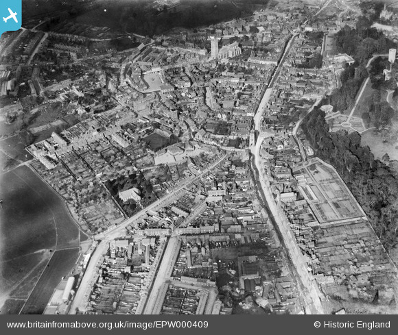
EPW000409 ENGLAND (1920). Warwick, from the south-west, 1920
© Hawlfraint cyfranwyr OpenStreetMap a thrwyddedwyd gan yr OpenStreetMap Foundation. 2025. Trwyddedir y gartograffeg fel CC BY-SA.
Delweddau cyfagos (9)
Manylion
| Pennawd | [EPW000409] Warwick, from the south-west, 1920 |
| Cyfeirnod | EPW000409 |
| Dyddiad | April-1920 |
| Dolen | |
| Enw lle | WARWICK |
| Plwyf | WARWICK |
| Ardal | |
| Gwlad | ENGLAND |
| Dwyreiniad / Gogleddiad | 427931, 264725 |
| Hydred / Lledred | -1.5905467902149, 52.279567466453 |
| Cyfeirnod Grid Cenedlaethol | SP279647 |
Pinnau
 DRIP |
Sunday 17th of January 2021 02:49:48 PM | |
 Glassman |
Sunday 4th of January 2015 01:16:34 PM |


![[EPW000409] Warwick, from the south-west, 1920](http://britainfromabove.org.uk/sites/all/libraries/aerofilms-images/public/100x100/EPW/000/EPW000409.jpg)
![[EPW000408] Priory Park and Warwick Castle, Warwick, from the south-west, 1920](http://britainfromabove.org.uk/sites/all/libraries/aerofilms-images/public/100x100/EPW/000/EPW000408.jpg)
![[EPW019741] The High Street and the town centre, Warwick, 1927](http://britainfromabove.org.uk/sites/all/libraries/aerofilms-images/public/100x100/EPW/019/EPW019741.jpg)
![[EPW019742] The Market Place and the town centre, Warwick, 1927](http://britainfromabove.org.uk/sites/all/libraries/aerofilms-images/public/100x100/EPW/019/EPW019742.jpg)
![[EPW000407] Priory Park, Warwick, from the south-west, 1920](http://britainfromabove.org.uk/sites/all/libraries/aerofilms-images/public/100x100/EPW/000/EPW000407.jpg)
![[EPW053229] The town centre, Warwick, 1937](http://britainfromabove.org.uk/sites/all/libraries/aerofilms-images/public/100x100/EPW/053/EPW053229.jpg)
![[EAW003265] The town centre, Warwick, from the west, 1946](http://britainfromabove.org.uk/sites/all/libraries/aerofilms-images/public/100x100/EAW/003/EAW003265.jpg)
![[EAW024691] St Mary's Church, Warwick Castle and the town centre, Warwick, from the north-west, 1949](http://britainfromabove.org.uk/sites/all/libraries/aerofilms-images/public/100x100/EAW/024/EAW024691.jpg)
![[EPW000410] Warwick, from the south-west, 1920](http://britainfromabove.org.uk/sites/all/libraries/aerofilms-images/public/100x100/EPW/000/EPW000410.jpg)