
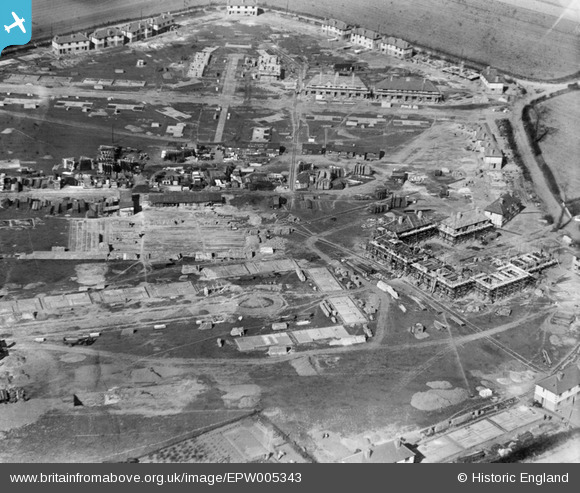
EPW005343 ENGLAND (1921). A new housing estate under construction at Marsh Green Road, Dagenham, 1921
© Hawlfraint cyfranwyr OpenStreetMap a thrwyddedwyd gan yr OpenStreetMap Foundation. 2025. Trwyddedir y gartograffeg fel CC BY-SA.
Delweddau cyfagos (13)
EPW005343

EPW005340

EPW005338

EPW006556

EPW006558

EPW005339

EPW005341

EPW006557

EPW006559

EAW026138

EAW026158

EPW005342

EPW035589

Manylion
| Pennawd | [EPW005343] A new housing estate under construction at Marsh Green Road, Dagenham, 1921 |
| Cyfeirnod | EPW005343 |
| Dyddiad | January-1921 |
| Dolen | |
| Enw lle | DAGENHAM |
| Plwyf | |
| Ardal | |
| Gwlad | ENGLAND |
| Dwyreiniad / Gogleddiad | 549306, 183653 |
| Hydred / Lledred | 0.15279499841309, 51.531535544989 |
| Cyfeirnod Grid Cenedlaethol | TQ493837 |
Pinnau
Byddwch y cyntaf i ychwanegu sylw at y ddelwedd hon!
Cyfraniadau Grŵp
In the top right corner of this picture is the junction of Whitebarn Lane, Marsh Green Road, Broad Street and Lower Broad Street. From the middle of the right edge of the picture is Whitebarn Lane where North Close meets it. North Close passes throught the group of houses on the right of the picture and is joined to South Close (the cul de sac running from the lower right of the picture) by a narrow pathway. At the junction top right, the road parallel to the top of the picture is Marsh Green Road which is intersected by Baddow Close. Above Marsh Green Road, heading left from the junction, is Lower Broad Street. Broad Street exits the picture top right. At the middle top of the picture, Lower Broad Street meets what became Heathway and heads off left to meet New Road (the old A13) at what became Chequers Corner named from The Chequers Public House. |
 Ken Stanton |
Saturday 30th of June 2012 04:40:58 PM |
Sorry !!! South Close starts slightly below the middle of the LEFT of the picture. |
Ken Stanton |
Saturday 30th of June 2012 04:40:58 PM |