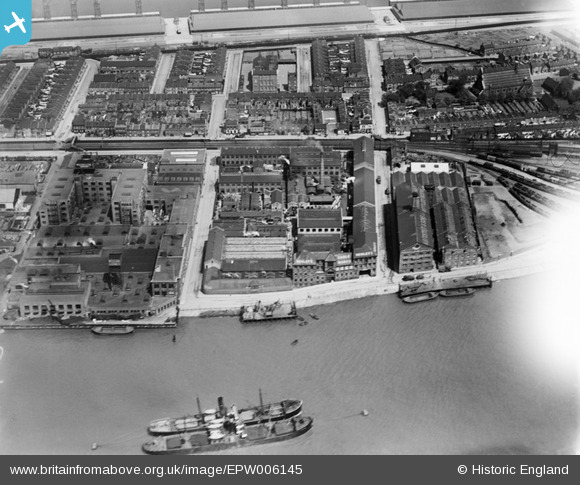
EPW006145 ENGLAND (1921). Stanley Road and environs, North Woolwich, 1921
© Hawlfraint cyfranwyr OpenStreetMap a thrwyddedwyd gan yr OpenStreetMap Foundation. 2025. Trwyddedir y gartograffeg fel CC BY-SA.
Delweddau cyfagos (30)
Manylion
| Pennawd | [EPW006145] Stanley Road and environs, North Woolwich, 1921 |
| Cyfeirnod | EPW006145 |
| Dyddiad | April-1921 |
| Dolen | |
| Enw lle | NORTH WOOLWICH |
| Plwyf | |
| Ardal | |
| Gwlad | ENGLAND |
| Dwyreiniad / Gogleddiad | 543000, 179794 |
| Hydred / Lledred | 0.060369673753172, 51.498488671927 |
| Cyfeirnod Grid Cenedlaethol | TQ430798 |
Pinnau
 MB |
Friday 14th of September 2012 11:11:11 PM | |
 MB |
Friday 14th of September 2012 11:10:37 PM | |
 MB |
Friday 14th of September 2012 11:09:32 PM | |
 MB |
Friday 14th of September 2012 10:59:42 PM | |
used to work there in printing dept in 1958 |
 don31142 |
Tuesday 16th of October 2012 05:26:12 PM |
 MB |
Friday 14th of September 2012 10:59:03 PM |


![[EPW006145] Stanley Road and environs, North Woolwich, 1921](http://britainfromabove.org.uk/sites/all/libraries/aerofilms-images/public/100x100/EPW/006/EPW006145.jpg)
![[EPW024252] Henley's Cable Works and environs, North Woolwich, 1928](http://britainfromabove.org.uk/sites/all/libraries/aerofilms-images/public/100x100/EPW/024/EPW024252.jpg)
![[EAW005318] The Standard Electric Cable and Telephone Works and the surrounding industrial area, North Woolwich, 1947](http://britainfromabove.org.uk/sites/all/libraries/aerofilms-images/public/100x100/EAW/005/EAW005318.jpg)
![[EPW057949] The North Pontoon, Standard Telephones and Cables Works and environs, North Woolwich, 1938](http://britainfromabove.org.uk/sites/all/libraries/aerofilms-images/public/100x100/EPW/057/EPW057949.jpg)
![[EAW005313] The Standard Industrial Estate, North Woolwich, 1947](http://britainfromabove.org.uk/sites/all/libraries/aerofilms-images/public/100x100/EAW/005/EAW005313.jpg)
![[EPW036585] W.T. Henley's Electric Cable Works and other factories, North Woolwich, 1931](http://britainfromabove.org.uk/sites/all/libraries/aerofilms-images/public/100x100/EPW/036/EPW036585.jpg)
![[EPW036584] W.T. Henley's Electric Cable Works and other factories, North Woolwich, 1931](http://britainfromabove.org.uk/sites/all/libraries/aerofilms-images/public/100x100/EPW/036/EPW036584.jpg)
![[EPW036583] W.T. Henley's Electric Cable Works and other factories and wharves, North Woolwich, 1931](http://britainfromabove.org.uk/sites/all/libraries/aerofilms-images/public/100x100/EPW/036/EPW036583.jpg)
![[EPW057948] The Standard Telephones and Cables Works and Griffith's Wharf, North Woolwich, 1938](http://britainfromabove.org.uk/sites/all/libraries/aerofilms-images/public/100x100/EPW/057/EPW057948.jpg)
![[EAW008315] The Standard Industrial Estate, North Woolwich, 1947](http://britainfromabove.org.uk/sites/all/libraries/aerofilms-images/public/100x100/EAW/008/EAW008315.jpg)
![[EPW036586] W.T. Henley's Electric Cable Works and other factories, North Woolwich, 1931](http://britainfromabove.org.uk/sites/all/libraries/aerofilms-images/public/100x100/EPW/036/EPW036586.jpg)
![[EPW008295] Western Electric Co Ltd Electric Cable and Telephone Works by Griffin Wharf, North Woolwich, 1923. This image has been produced from a print.](http://britainfromabove.org.uk/sites/all/libraries/aerofilms-images/public/100x100/EPW/008/EPW008295.jpg)
![[EPW057947] The Standard Telephones and Cables Works and Griffith's Wharf, North Woolwich, 1938](http://britainfromabove.org.uk/sites/all/libraries/aerofilms-images/public/100x100/EPW/057/EPW057947.jpg)
![[EPW057950] The Standard Telephones and Cables Works and Griffith's Wharf, North Woolwich, 1938](http://britainfromabove.org.uk/sites/all/libraries/aerofilms-images/public/100x100/EPW/057/EPW057950.jpg)
![[EPW050840] The Standard Telephones and Cables Ltd Works and environs, North Woolwich, 1936](http://britainfromabove.org.uk/sites/all/libraries/aerofilms-images/public/100x100/EPW/050/EPW050840.jpg)
![[EPW050842] The Standard Telephones and Cables Ltd Works and environs, North Woolwich, 1936](http://britainfromabove.org.uk/sites/all/libraries/aerofilms-images/public/100x100/EPW/050/EPW050842.jpg)
![[EAW005312] The Standard Industrial Estate alongside the Royal Albert Dock, North Woolwich, 1947](http://britainfromabove.org.uk/sites/all/libraries/aerofilms-images/public/100x100/EAW/005/EAW005312.jpg)
![[EAW008316] The Standard Industrial Estate, North Woolwich, 1947](http://britainfromabove.org.uk/sites/all/libraries/aerofilms-images/public/100x100/EAW/008/EAW008316.jpg)
![[EAW005310] The Standard Electric Cable and Telephone Works, North Woolwich, 1947](http://britainfromabove.org.uk/sites/all/libraries/aerofilms-images/public/100x100/EAW/005/EAW005310.jpg)
![[EPW050841] Tugboats alongside the Standard Telephones and Cables Ltd Works and Griffith's Wharf, North Woolwich, 1936](http://britainfromabove.org.uk/sites/all/libraries/aerofilms-images/public/100x100/EPW/050/EPW050841.jpg)
![[EAW005315] The Standard Industrial Estate alongside the Royal Albert Dock, North Woolwich, 1947. This image was marked by Aerofilms Ltd for photo editing.](http://britainfromabove.org.uk/sites/all/libraries/aerofilms-images/public/100x100/EAW/005/EAW005315.jpg)
![[EAW005317] The Standard Electric Cable and Telephone Works and the surrounding area, North Woolwich, 1947](http://britainfromabove.org.uk/sites/all/libraries/aerofilms-images/public/100x100/EAW/005/EAW005317.jpg)
![[EAW005311] The Standard Electric Cable and Telephone Works and the surrounding area, North Woolwich, 1947](http://britainfromabove.org.uk/sites/all/libraries/aerofilms-images/public/100x100/EAW/005/EAW005311.jpg)
![[EPW057953] The Standard Telephones and Cables Works, Griffith's Wharf and environs, North Woolwich, 1938. This image has been produced from a print.](http://britainfromabove.org.uk/sites/all/libraries/aerofilms-images/public/100x100/EPW/057/EPW057953.jpg)
![[EPW050843] Tugboats alongside the Standard Telephones and Cables Ltd Works and Griffith's Wharf, North Woolwich, 1936](http://britainfromabove.org.uk/sites/all/libraries/aerofilms-images/public/100x100/EPW/050/EPW050843.jpg)
![[EAW005319] The Standard Electric Cable and Telephone Works, North Woolwich, 1947](http://britainfromabove.org.uk/sites/all/libraries/aerofilms-images/public/100x100/EAW/005/EAW005319.jpg)
![[EAW005316] The Standard Industrial Estate, North Woolwich, 1947](http://britainfromabove.org.uk/sites/all/libraries/aerofilms-images/public/100x100/EAW/005/EAW005316.jpg)
![[EPW050844] Tugboats alongside the Standard Telephones and Cables Ltd Works and Griffith's Wharf, North Woolwich, 1936](http://britainfromabove.org.uk/sites/all/libraries/aerofilms-images/public/100x100/EPW/050/EPW050844.jpg)
![[EPW057954] The Standard Telephones and Cables Works, Griffith's Wharf and environs, North Woolwich, 1938. This image has been produced from a print.](http://britainfromabove.org.uk/sites/all/libraries/aerofilms-images/public/100x100/EPW/057/EPW057954.jpg)
![[EAW005314] The Standard Industrial Estate alongside the Royal Albert Dock, North Woolwich, 1947](http://britainfromabove.org.uk/sites/all/libraries/aerofilms-images/public/100x100/EAW/005/EAW005314.jpg)