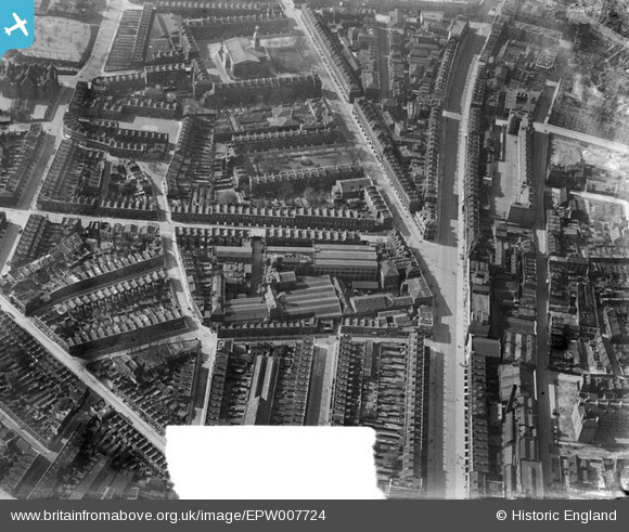
EPW007724 ENGLAND (1922). The Waygood Otis Engineering Works, Newington, 1922
© Hawlfraint cyfranwyr OpenStreetMap a thrwyddedwyd gan yr OpenStreetMap Foundation. 2025. Trwyddedir y gartograffeg fel CC BY-SA.
Delweddau cyfagos (29)
Manylion
| Pennawd | [EPW007724] The Waygood Otis Engineering Works, Newington, 1922 |
| Cyfeirnod | EPW007724 |
| Dyddiad | April-1922 |
| Dolen | |
| Enw lle | NEWINGTON |
| Plwyf | |
| Ardal | |
| Gwlad | ENGLAND |
| Dwyreiniad / Gogleddiad | 532608, 179333 |
| Hydred / Lledred | -0.089440374083815, 51.496879364371 |
| Cyfeirnod Grid Cenedlaethol | TQ326793 |
Pinnau
 K Mapes |
Friday 6th of June 2014 09:32:30 PM | |
 K Mapes |
Friday 6th of June 2014 09:31:33 PM | |
 K Mapes |
Friday 6th of June 2014 09:30:35 PM | |
 Chelsea61 |
Sunday 9th of June 2013 05:51:20 PM | |
 Chelsea61 |
Sunday 9th of June 2013 05:51:02 PM | |
 Chelsea61 |
Sunday 9th of June 2013 05:50:34 PM | |
 Chelsea61 |
Sunday 9th of June 2013 05:50:15 PM | |
 Chelsea61 |
Sunday 9th of June 2013 05:36:27 PM |


![[EPW007724] The Waygood Otis Engineering Works, Newington, 1922](http://britainfromabove.org.uk/sites/all/libraries/aerofilms-images/public/100x100/EPW/007/EPW007724.jpg)
![[EAW021507] Great Dover Street and environs, Newington, 1949. This image has been produced from a print marked by Aerofilms Ltd for photo editing.](http://britainfromabove.org.uk/sites/all/libraries/aerofilms-images/public/100x100/EAW/021/EAW021507.jpg)
![[EPW015749] Great Dover Street and environs, Bermondsey, 1926](http://britainfromabove.org.uk/sites/all/libraries/aerofilms-images/public/100x100/EPW/015/EPW015749.jpg)
![[EPW007725] The Waygood Otis Engineering Works, Newington, 1922](http://britainfromabove.org.uk/sites/all/libraries/aerofilms-images/public/100x100/EPW/007/EPW007725.jpg)
![[EPW015753] Falmouth Road and environs, Bermondsey, 1926. This image has been produced from a print affected by flare.](http://britainfromabove.org.uk/sites/all/libraries/aerofilms-images/public/100x100/EPW/015/EPW015753.jpg)
![[EPW007728] The Waygood Otis Engineering Works, Newington, 1922](http://britainfromabove.org.uk/sites/all/libraries/aerofilms-images/public/100x100/EPW/007/EPW007728.jpg)
![[EAW021505] Falmouth Road and environs, Newington, 1949. This image has been produced from a damaged negative.](http://britainfromabove.org.uk/sites/all/libraries/aerofilms-images/public/100x100/EAW/021/EAW021505.jpg)
![[EPW007727] The Waygood Otis Engineering Works, Newington, 1922](http://britainfromabove.org.uk/sites/all/libraries/aerofilms-images/public/100x100/EPW/007/EPW007727.jpg)
![[EAW021509] Great Dover Street, Deverell Street and environs, Newington, 1949. This image has been produced from a print marked by Aerofilms Ltd for photo editing.](http://britainfromabove.org.uk/sites/all/libraries/aerofilms-images/public/100x100/EAW/021/EAW021509.jpg)
![[EPW007726] The Waygood Otis Engineering Works and Merrick Square, Newington, 1922](http://britainfromabove.org.uk/sites/all/libraries/aerofilms-images/public/100x100/EPW/007/EPW007726.jpg)
![[EPW007723] The Waygood Otis Engineering Works, Newington, 1922](http://britainfromabove.org.uk/sites/all/libraries/aerofilms-images/public/100x100/EPW/007/EPW007723.jpg)
![[EAW021506] Falmouth Road and environs, Newington, 1949. This image has been produced from a damaged negative.](http://britainfromabove.org.uk/sites/all/libraries/aerofilms-images/public/100x100/EAW/021/EAW021506.jpg)
![[EPW015752] Great Dover Street and environs, Bermondsey, 1926](http://britainfromabove.org.uk/sites/all/libraries/aerofilms-images/public/100x100/EPW/015/EPW015752.jpg)
![[EAW021503] Great Dover Street and environs, Newington, 1949. This image has been produced from a damaged negative.](http://britainfromabove.org.uk/sites/all/libraries/aerofilms-images/public/100x100/EAW/021/EAW021503.jpg)
![[EPW015751] Harper Road, Great Dover Street and environs, Bermondsey, 1926. This image has been produced from a print marked by Aerofilms Ltd for photo editing.](http://britainfromabove.org.uk/sites/all/libraries/aerofilms-images/public/100x100/EPW/015/EPW015751.jpg)
![[EAW021501] Deverell Street and environs, Newington, 1949. This image has been produced from a damaged negative.](http://britainfromabove.org.uk/sites/all/libraries/aerofilms-images/public/100x100/EAW/021/EAW021501.jpg)
![[EAW021502] Great Dover Street and environs, Newington, 1949. This image has been produced from a damaged negative.](http://britainfromabove.org.uk/sites/all/libraries/aerofilms-images/public/100x100/EAW/021/EAW021502.jpg)
![[EPW015760] Falmouth Road and environs, Bermondsey, 1926. This image has been produced from a print.](http://britainfromabove.org.uk/sites/all/libraries/aerofilms-images/public/100x100/EPW/015/EPW015760.jpg)
![[EPW016619] The Waygood Otis Engineering Works, Bermondsey, 1926](http://britainfromabove.org.uk/sites/all/libraries/aerofilms-images/public/100x100/EPW/016/EPW016619.jpg)
![[EPW015750] Great Dover Street and environs, Bermondsey, 1926](http://britainfromabove.org.uk/sites/all/libraries/aerofilms-images/public/100x100/EPW/015/EPW015750.jpg)
![[EPW016620] The Waygood Otis Engineering Works and environs, Bermondsey, 1926](http://britainfromabove.org.uk/sites/all/libraries/aerofilms-images/public/100x100/EPW/016/EPW016620.jpg)
![[EPW015754] Great Dover Street and environs, Bermondsey, 1926. This image has been produced from a print affected by flare.](http://britainfromabove.org.uk/sites/all/libraries/aerofilms-images/public/100x100/EPW/015/EPW015754.jpg)
![[EAW021510] Falmouth Road, the Rockingham Estate and environs, Newington, 1949. This image has been produced from a print marked by Aerofilms Ltd for photo editing.](http://britainfromabove.org.uk/sites/all/libraries/aerofilms-images/public/100x100/EAW/021/EAW021510.jpg)
![[EPW015759] Falmouth Road and environs, Bermondsey, 1926. This image has been produced from a print.](http://britainfromabove.org.uk/sites/all/libraries/aerofilms-images/public/100x100/EPW/015/EPW015759.jpg)
![[EAW021504] Great Dover Street and environs, Newington, 1949. This image has been produced from a damaged negative.](http://britainfromabove.org.uk/sites/all/libraries/aerofilms-images/public/100x100/EAW/021/EAW021504.jpg)
![[EPW055342] The Holy Trinity Church, Merrick Square and the surrounding residential area, The Borough, 1937](http://britainfromabove.org.uk/sites/all/libraries/aerofilms-images/public/100x100/EPW/055/EPW055342.jpg)
![[EAW021500] Falmouth Road and environs, Newington, 1949. This image was marked by Aerofilms Ltd for photo editing.](http://britainfromabove.org.uk/sites/all/libraries/aerofilms-images/public/100x100/EAW/021/EAW021500.jpg)
![[EAW021508] Falmouth Road, the Rockingham Estate and environs, Newington, 1949. This image has been produced from a print marked by Aerofilms Ltd for photo editing.](http://britainfromabove.org.uk/sites/all/libraries/aerofilms-images/public/100x100/EAW/021/EAW021508.jpg)
![[EAW000535] Southwark and Great Dover Street, The Borough, from the south-east, 1946](http://britainfromabove.org.uk/sites/all/libraries/aerofilms-images/public/100x100/EAW/000/EAW000535.jpg)