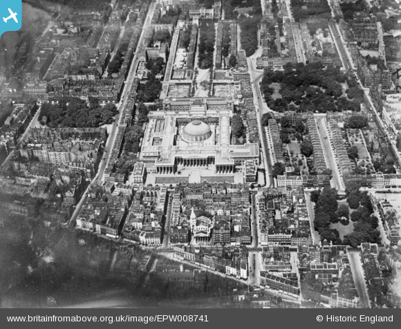
EPW008741 ENGLAND (1923). The British Museum, Bloomsbury, 1923. This image has been produced from a copy-negative.
© Hawlfraint cyfranwyr OpenStreetMap a thrwyddedwyd gan yr OpenStreetMap Foundation. 2025. Trwyddedir y gartograffeg fel CC BY-SA.
Delweddau cyfagos (26)
Manylion
| Pennawd | [EPW008741] The British Museum, Bloomsbury, 1923. This image has been produced from a copy-negative. |
| Cyfeirnod | EPW008741 |
| Dyddiad | 1923 |
| Dolen | |
| Enw lle | BLOOMSBURY |
| Plwyf | |
| Ardal | |
| Gwlad | ENGLAND |
| Dwyreiniad / Gogleddiad | 530098, 181668 |
| Hydred / Lledred | -0.12472073574174, 51.518448917537 |
| Cyfeirnod Grid Cenedlaethol | TQ301817 |
Pinnau
 billyfern |
Monday 3rd of November 2014 05:48:41 PM | |
 billyfern |
Monday 3rd of November 2014 05:48:20 PM | |
 billyfern |
Monday 3rd of November 2014 05:47:34 PM | |
 billyfern |
Monday 3rd of November 2014 05:47:10 PM | |
 billyfern |
Monday 3rd of November 2014 05:46:42 PM | |
 billyfern |
Monday 3rd of November 2014 05:45:37 PM | |
 billyfern |
Monday 3rd of November 2014 05:44:58 PM |


![[EPW008741] The British Museum, Bloomsbury, 1923. This image has been produced from a copy-negative.](http://britainfromabove.org.uk/sites/all/libraries/aerofilms-images/public/100x100/EPW/008/EPW008741.jpg)
![[EPW005920] The British Museum, Bloomsbury, 1921](http://britainfromabove.org.uk/sites/all/libraries/aerofilms-images/public/100x100/EPW/005/EPW005920.jpg)
![[EPW039568] The British Museum and environs, Bloomsbury, 1932](http://britainfromabove.org.uk/sites/all/libraries/aerofilms-images/public/100x100/EPW/039/EPW039568.jpg)
![[EPW039567] The British Museum and environs, Bloomsbury, 1932](http://britainfromabove.org.uk/sites/all/libraries/aerofilms-images/public/100x100/EPW/039/EPW039567.jpg)
![[EAW041950] The British Museum, Bloomsbury, 1952](http://britainfromabove.org.uk/sites/all/libraries/aerofilms-images/public/100x100/EAW/041/EAW041950.jpg)
![[EPW006680] The British Museum, Bloomsbury, 1921](http://britainfromabove.org.uk/sites/all/libraries/aerofilms-images/public/100x100/EPW/006/EPW006680.jpg)
![[EPW016654] The British Museum, Bloomsbury, 1926. This image has been produced from a print.](http://britainfromabove.org.uk/sites/all/libraries/aerofilms-images/public/100x100/EPW/016/EPW016654.jpg)
![[EPW020960] The British Museum, Bloomsbury, 1928](http://britainfromabove.org.uk/sites/all/libraries/aerofilms-images/public/100x100/EPW/020/EPW020960.jpg)
![[EAW030117] The British Museum and environs, Bloomsbury, 1950](http://britainfromabove.org.uk/sites/all/libraries/aerofilms-images/public/100x100/EAW/030/EAW030117.jpg)
![[EPW020959] The British Museum, Bloomsbury, 1928](http://britainfromabove.org.uk/sites/all/libraries/aerofilms-images/public/100x100/EPW/020/EPW020959.jpg)
![[EPW019025] The British Museum, Bloomsbury, 1927](http://britainfromabove.org.uk/sites/all/libraries/aerofilms-images/public/100x100/EPW/019/EPW019025.jpg)
![[EAW041945] New Oxford Street and Bloomsbury Square, St Giles, 1952](http://britainfromabove.org.uk/sites/all/libraries/aerofilms-images/public/100x100/EAW/041/EAW041945.jpg)
![[EAW041944] The British Museum and environs, Bloomsbury, 1952](http://britainfromabove.org.uk/sites/all/libraries/aerofilms-images/public/100x100/EAW/041/EAW041944.jpg)
![[EPW024279] The British Museum and Russell Square, Bloomsbury, 1928](http://britainfromabove.org.uk/sites/all/libraries/aerofilms-images/public/100x100/EPW/024/EPW024279.jpg)
![[EPW016653] The British Museum and environs, Bloomsbury, 1926](http://britainfromabove.org.uk/sites/all/libraries/aerofilms-images/public/100x100/EPW/016/EPW016653.jpg)
![[EAW041942] New Oxford Street, St Giles, 1952](http://britainfromabove.org.uk/sites/all/libraries/aerofilms-images/public/100x100/EAW/041/EAW041942.jpg)
![[EPW060553] The University of London, British Museum, Russell Square and environs, Bloomsbury, 1939](http://britainfromabove.org.uk/sites/all/libraries/aerofilms-images/public/100x100/EPW/060/EPW060553.jpg)
![[EPW060556] The University of London, British Museum and environs, Bloomsbury, 1939](http://britainfromabove.org.uk/sites/all/libraries/aerofilms-images/public/100x100/EPW/060/EPW060556.jpg)
![[EAW000479] The British Museum, University of London and environs, Bloomsbury, 1946](http://britainfromabove.org.uk/sites/all/libraries/aerofilms-images/public/100x100/EAW/000/EAW000479.jpg)
![[EPW060557] The University of London, British Museum, Russell Square and environs, Bloomsbury, 1939](http://britainfromabove.org.uk/sites/all/libraries/aerofilms-images/public/100x100/EPW/060/EPW060557.jpg)
![[EPW060555] The University of London, British Museum, Russell Square and environs, Bloomsbury, 1939](http://britainfromabove.org.uk/sites/all/libraries/aerofilms-images/public/100x100/EPW/060/EPW060555.jpg)
![[EAW050844] High Holborn and New Oxford Street, Holborn, 1953](http://britainfromabove.org.uk/sites/all/libraries/aerofilms-images/public/100x100/EAW/050/EAW050844.jpg)
![[EAW041949] St Giles' Circus and Bedford Square, Bloomsbury, 1952](http://britainfromabove.org.uk/sites/all/libraries/aerofilms-images/public/100x100/EAW/041/EAW041949.jpg)
![[EAW041943] St Giles' Circus, Bedford Square and the British Museum, Bloomsbury, 1952](http://britainfromabove.org.uk/sites/all/libraries/aerofilms-images/public/100x100/EAW/041/EAW041943.jpg)
![[EAW000478] The British Museum, University of London and environs, Bloomsbury, 1946](http://britainfromabove.org.uk/sites/all/libraries/aerofilms-images/public/100x100/EAW/000/EAW000478.jpg)
![[EAW041948] St Giles' Circus, Bedford Square and the British Museum, Bloomsbury, 1952](http://britainfromabove.org.uk/sites/all/libraries/aerofilms-images/public/100x100/EAW/041/EAW041948.jpg)
