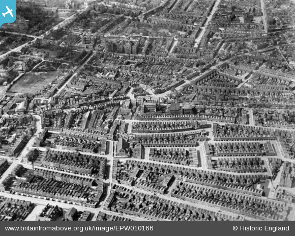
EPW010166 ENGLAND (1924). Wells Crescent and environs, Camberwell, 1924. This image has been produced from a copy-negative.
© Hawlfraint cyfranwyr OpenStreetMap a thrwyddedwyd gan yr OpenStreetMap Foundation. 2025. Trwyddedir y gartograffeg fel CC BY-SA.
Delweddau cyfagos (6)
Manylion
| Pennawd | [EPW010166] Wells Crescent and environs, Camberwell, 1924. This image has been produced from a copy-negative. |
| Cyfeirnod | EPW010166 |
| Dyddiad | April-1924 |
| Dolen | |
| Enw lle | CAMBERWELL |
| Plwyf | |
| Ardal | |
| Gwlad | ENGLAND |
| Dwyreiniad / Gogleddiad | 533419, 177133 |
| Hydred / Lledred | -0.078594404361102, 51.476916085855 |
| Cyfeirnod Grid Cenedlaethol | TQ334771 |
Pinnau
 Chaz |
Sunday 8th of August 2021 12:34:53 AM | |
 Chaz |
Sunday 8th of August 2021 12:24:49 AM | |
 Chaz |
Sunday 8th of August 2021 12:21:26 AM | |
 Chaz |
Sunday 8th of August 2021 12:17:42 AM | |
 Chaz |
Sunday 8th of August 2021 12:15:55 AM | |
 Chelsea61 |
Thursday 11th of September 2014 06:35:48 PM |


![[EPW010166] Wells Crescent and environs, Camberwell, 1924. This image has been produced from a copy-negative.](http://britainfromabove.org.uk/sites/all/libraries/aerofilms-images/public/100x100/EPW/010/EPW010166.jpg)
![[EPW010160] The Triangle, Wells Crescent and environs, Camberwell, 1924. This image has been produced from a copy-negative.](http://britainfromabove.org.uk/sites/all/libraries/aerofilms-images/public/100x100/EPW/010/EPW010160.jpg)
![[EPW011157] Southampton Street and environs, Camberwell, 1924](http://britainfromabove.org.uk/sites/all/libraries/aerofilms-images/public/100x100/EPW/011/EPW011157.jpg)
![[EPW011158] Wells Crescent and environs, Camberwell, 1924](http://britainfromabove.org.uk/sites/all/libraries/aerofilms-images/public/100x100/EPW/011/EPW011158.jpg)
![[EPW011159] Southampton Street and environs, Camberwell, 1924](http://britainfromabove.org.uk/sites/all/libraries/aerofilms-images/public/100x100/EPW/011/EPW011159.jpg)
![[EPW010956] Brunswick Park, Southampton Way and the surrounding residential area, Camberwell, 1924. This image has been produced from a copy-negative.](http://britainfromabove.org.uk/sites/all/libraries/aerofilms-images/public/100x100/EPW/010/EPW010956.jpg)