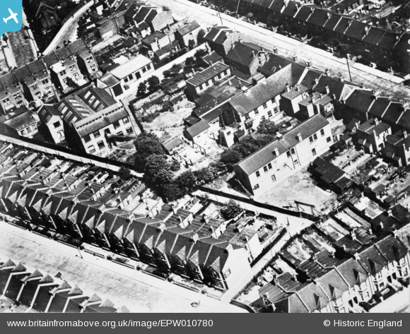
EPW010780 ENGLAND (1924). Kent Road and environs, Acton Green, 1924. This image has been produced from a copy-negative.
© Hawlfraint cyfranwyr OpenStreetMap a thrwyddedwyd gan yr OpenStreetMap Foundation. 2025. Trwyddedir y gartograffeg fel CC BY-SA.
Delweddau cyfagos (32)
Manylion
| Pennawd | [EPW010780] Kent Road and environs, Acton Green, 1924. This image has been produced from a copy-negative. |
| Cyfeirnod | EPW010780 |
| Dyddiad | June-1924 |
| Dolen | |
| Enw lle | ACTON GREEN |
| Plwyf | |
| Ardal | |
| Gwlad | ENGLAND |
| Dwyreiniad / Gogleddiad | 520302, 179137 |
| Hydred / Lledred | -0.26671510368811, 51.49787107137 |
| Cyfeirnod Grid Cenedlaethol | TQ203791 |
Pinnau
 Class31 |
Thursday 11th of September 2014 07:03:26 AM | |
 Class31 |
Thursday 11th of September 2014 07:00:06 AM | |
 Class31 |
Thursday 11th of September 2014 06:59:29 AM | |
 Class31 |
Thursday 11th of September 2014 06:59:00 AM | |
 Class31 |
Thursday 11th of September 2014 06:58:29 AM |
Cyfraniadau Grŵp
This is the area between Kent Road and Rothschild Road in London W4 just south of South Acton underground station. |
 Class31 |
Friday 26th of September 2014 04:40:02 PM |
Great "spot" Class31! We'll update the catalogue with your data and post the new record here in due course. You may be interested to know that the original Aerofilms Ltd Register entry says "Wimbledon Close up houses". Yours, Katy Britain from Above Cataloguing Team Leader |
Katy Whitaker |
Friday 26th of September 2014 04:40:02 PM |
We are looking broadly east. |
 Class31 |
Thursday 11th of September 2014 07:03:54 AM |
Eureka |
 Class31 |
Thursday 11th of September 2014 06:57:33 AM |


![[EPW010780] Kent Road and environs, Acton Green, 1924. This image has been produced from a copy-negative.](http://britainfromabove.org.uk/sites/all/libraries/aerofilms-images/public/100x100/EPW/010/EPW010780.jpg)
![[EAW048458] Evershed and Vignoles Ltd Acton Lane Electrical Works and the surrounding residential area, Acton Green, 1953. This image was marked by Aerofilms Ltd for photo editing.](http://britainfromabove.org.uk/sites/all/libraries/aerofilms-images/public/100x100/EAW/048/EAW048458.jpg)
![[EPW025223] The Acton Lane Electrical Works and environs, Acton Green, 1928](http://britainfromabove.org.uk/sites/all/libraries/aerofilms-images/public/100x100/EPW/025/EPW025223.jpg)
![[EPW025225] The Acton Lane Electrical Works and environs, Acton Green, 1928](http://britainfromabove.org.uk/sites/all/libraries/aerofilms-images/public/100x100/EPW/025/EPW025225.jpg)
![[EAW048449] Evershed and Vignoles Ltd Acton Lane Electrical Works and the surrounding residential area, Acton Green, 1953. This image was marked by Aerofilms Ltd for photo editing.](http://britainfromabove.org.uk/sites/all/libraries/aerofilms-images/public/100x100/EAW/048/EAW048449.jpg)
![[EAW048450] Evershed and Vignoles Ltd Acton Lane Electrical Works, Acton Green, 1953. This image was marked by Aerofilms Ltd for photo editing.](http://britainfromabove.org.uk/sites/all/libraries/aerofilms-images/public/100x100/EAW/048/EAW048450.jpg)
![[EAW048451] Evershed and Vignoles Ltd Acton Lane Electrical Works, Acton Green, 1953. This image was marked by Aerofilms Ltd for photo editing.](http://britainfromabove.org.uk/sites/all/libraries/aerofilms-images/public/100x100/EAW/048/EAW048451.jpg)
![[EPW025227] The Acton Lane Electrical Works and environs, Acton Green, 1928](http://britainfromabove.org.uk/sites/all/libraries/aerofilms-images/public/100x100/EPW/025/EPW025227.jpg)
![[EPW009678] Evershed and Vignoles Ltd Acton Lane Works, Acton Green, 1923](http://britainfromabove.org.uk/sites/all/libraries/aerofilms-images/public/100x100/EPW/009/EPW009678.jpg)
![[EAW048454] Evershed and Vignoles Ltd Acton Lane Electrical Works, Acton Green, 1953. This image was marked by Aerofilms Ltd for photo editing.](http://britainfromabove.org.uk/sites/all/libraries/aerofilms-images/public/100x100/EAW/048/EAW048454.jpg)
![[EAW048448] Evershed and Vignoles Ltd Acton Lane Electrical Works and the surrounding residential area, Acton Green, 1953. This image was marked by Aerofilms Ltd for photo editing.](http://britainfromabove.org.uk/sites/all/libraries/aerofilms-images/public/100x100/EAW/048/EAW048448.jpg)
![[EAW048452] Evershed and Vignoles Ltd Acton Lane Electrical Works, Acton Green, 1953. This image was marked by Aerofilms Ltd for photo editing.](http://britainfromabove.org.uk/sites/all/libraries/aerofilms-images/public/100x100/EAW/048/EAW048452.jpg)
![[EAW048453] Evershed and Vignoles Ltd Acton Lane Electrical Works, Acton Green, 1953. This image was marked by Aerofilms Ltd for photo editing.](http://britainfromabove.org.uk/sites/all/libraries/aerofilms-images/public/100x100/EAW/048/EAW048453.jpg)
![[EPW025222] The Acton Lane Electrical Works and environs, Acton Green, 1928](http://britainfromabove.org.uk/sites/all/libraries/aerofilms-images/public/100x100/EPW/025/EPW025222.jpg)
![[EAW048455] Evershed and Vignoles Ltd Acton Lane Electrical Works, Acton Green, 1953. This image was marked by Aerofilms Ltd for photo editing.](http://britainfromabove.org.uk/sites/all/libraries/aerofilms-images/public/100x100/EAW/048/EAW048455.jpg)
![[EAW048456] Evershed and Vignoles Ltd Acton Lane Electrical Works and the surrounding residential area, Acton Green, 1953. This image was marked by Aerofilms Ltd for photo editing.](http://britainfromabove.org.uk/sites/all/libraries/aerofilms-images/public/100x100/EAW/048/EAW048456.jpg)
![[EPW009677] Evershed and Vignoles Ltd Acton Lane Works, Acton Green, 1923](http://britainfromabove.org.uk/sites/all/libraries/aerofilms-images/public/100x100/EPW/009/EPW009677.jpg)
![[EPW021919] Cunnington Street and Evershed & Vignoles Electrical Works, Chiswick, 1928](http://britainfromabove.org.uk/sites/all/libraries/aerofilms-images/public/100x100/EPW/021/EPW021919.jpg)
![[EPW025224] The Acton Lane Electrical Works and environs, Acton Green, 1928](http://britainfromabove.org.uk/sites/all/libraries/aerofilms-images/public/100x100/EPW/025/EPW025224.jpg)
![[EAW048457] Evershed and Vignoles Ltd Acton Lane Electrical Works, Acton Green, 1953. This image was marked by Aerofilms Ltd for photo editing.](http://britainfromabove.org.uk/sites/all/libraries/aerofilms-images/public/100x100/EAW/048/EAW048457.jpg)
![[EPW009673] Evershed and Vignoles Ltd Acton Lane Works, Acton Green, 1923](http://britainfromabove.org.uk/sites/all/libraries/aerofilms-images/public/100x100/EPW/009/EPW009673.jpg)
![[EPW021918] Cunnington Street and Evershed & Vignoles Electrical Works, Chiswick, 1928](http://britainfromabove.org.uk/sites/all/libraries/aerofilms-images/public/100x100/EPW/021/EPW021918.jpg)
![[EPW009679] Evershed and Vignoles Ltd Acton Lane Works, Acton Green, 1923](http://britainfromabove.org.uk/sites/all/libraries/aerofilms-images/public/100x100/EPW/009/EPW009679.jpg)
![[EPW025226] The Acton Lane Electrical Works and environs, Acton Green, 1928](http://britainfromabove.org.uk/sites/all/libraries/aerofilms-images/public/100x100/EPW/025/EPW025226.jpg)
![[EPW009675] Evershed and Vignoles Ltd Acton Lane Works, Acton Green, 1923](http://britainfromabove.org.uk/sites/all/libraries/aerofilms-images/public/100x100/EPW/009/EPW009675.jpg)
![[EPW009674] Evershed and Vignoles Ltd Acton Lane Works, Acton Green, 1923](http://britainfromabove.org.uk/sites/all/libraries/aerofilms-images/public/100x100/EPW/009/EPW009674.jpg)
![[EPW021922] Evershed & Vignoles Electrical Works and Acton Lane, Chiswick, 1928](http://britainfromabove.org.uk/sites/all/libraries/aerofilms-images/public/100x100/EPW/021/EPW021922.jpg)
![[EPW021920] Evershed & Vignoles Electrical Works and Acton Green, Chiswick, 1928](http://britainfromabove.org.uk/sites/all/libraries/aerofilms-images/public/100x100/EPW/021/EPW021920.jpg)