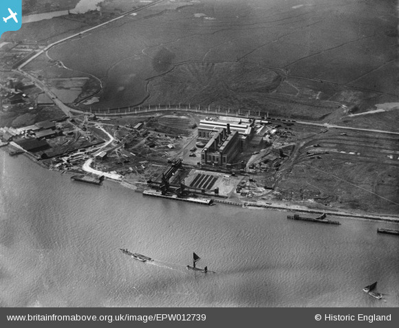
EPW012739 ENGLAND (1925). Barking Power Station, Creekmouth, 1925
© Hawlfraint cyfranwyr OpenStreetMap a thrwyddedwyd gan yr OpenStreetMap Foundation. 2025. Trwyddedir y gartograffeg fel CC BY-SA.
Delweddau cyfagos (32)
Manylion
| Pennawd | [EPW012739] Barking Power Station, Creekmouth, 1925 |
| Cyfeirnod | EPW012739 |
| Dyddiad | April-1925 |
| Dolen | |
| Enw lle | CREEKMOUTH |
| Plwyf | |
| Ardal | |
| Gwlad | ENGLAND |
| Dwyreiniad / Gogleddiad | 546542, 181763 |
| Hydred / Lledred | 0.11218494084909, 51.515275603826 |
| Cyfeirnod Grid Cenedlaethol | TQ465818 |
Pinnau
Cyfraniadau Grŵp
 Oliver Brookes |
Thursday 21st of March 2013 02:59:53 PM |


![[EPW012739] Barking Power Station, Creekmouth, 1925](http://britainfromabove.org.uk/sites/all/libraries/aerofilms-images/public/100x100/EPW/012/EPW012739.jpg)
![[EPW010662] Barking Power Station, Creekmouth, 1924](http://britainfromabove.org.uk/sites/all/libraries/aerofilms-images/public/100x100/EPW/010/EPW010662.jpg)
![[EPW009691] Barking Power Station under construction, Creekmouth, 1923](http://britainfromabove.org.uk/sites/all/libraries/aerofilms-images/public/100x100/EPW/009/EPW009691.jpg)
![[EPW009686] Barking Power Station under construction, Creekmouth, 1923](http://britainfromabove.org.uk/sites/all/libraries/aerofilms-images/public/100x100/EPW/009/EPW009686.jpg)
![[EPW009687] Barking Power Station under construction, Creekmouth, 1923](http://britainfromabove.org.uk/sites/all/libraries/aerofilms-images/public/100x100/EPW/009/EPW009687.jpg)
![[EPW009688] Barking Power Station under construction, Creekmouth, 1923](http://britainfromabove.org.uk/sites/all/libraries/aerofilms-images/public/100x100/EPW/009/EPW009688.jpg)
![[EPW009692] Barking Power Station under construction, Creekmouth, 1923](http://britainfromabove.org.uk/sites/all/libraries/aerofilms-images/public/100x100/EPW/009/EPW009692.jpg)
![[EPW012743] Barking Power Station, Creekmouth, 1925](http://britainfromabove.org.uk/sites/all/libraries/aerofilms-images/public/100x100/EPW/012/EPW012743.jpg)
![[EPW009685] Barking Power Station under construction, Creekmouth, 1923](http://britainfromabove.org.uk/sites/all/libraries/aerofilms-images/public/100x100/EPW/009/EPW009685.jpg)
![[EPW036789] The Creekmouth Power Station and the Ripple Level, Creekmouth, from the south-east, 1931](http://britainfromabove.org.uk/sites/all/libraries/aerofilms-images/public/100x100/EPW/036/EPW036789.jpg)
![[EPW010665] Barking Power Station, Creekmouth, 1924](http://britainfromabove.org.uk/sites/all/libraries/aerofilms-images/public/100x100/EPW/010/EPW010665.jpg)
![[EPW032828] Barking Power Station, Creekmouth, 1930](http://britainfromabove.org.uk/sites/all/libraries/aerofilms-images/public/100x100/EPW/032/EPW032828.jpg)
![[EAW001441] Barking Power Station, Creekmouth, 1946](http://britainfromabove.org.uk/sites/all/libraries/aerofilms-images/public/100x100/EAW/001/EAW001441.jpg)
![[EPW010661] Barking Power Station, Creekmouth, 1924](http://britainfromabove.org.uk/sites/all/libraries/aerofilms-images/public/100x100/EPW/010/EPW010661.jpg)
![[EPW009689] Barking Power Station under construction, Creekmouth, 1923](http://britainfromabove.org.uk/sites/all/libraries/aerofilms-images/public/100x100/EPW/009/EPW009689.jpg)
![[EPW010667] Barking Power Station, Creekmouth, 1924](http://britainfromabove.org.uk/sites/all/libraries/aerofilms-images/public/100x100/EPW/010/EPW010667.jpg)
![[EPW010666] Barking Power Station, Creekmouth, 1924](http://britainfromabove.org.uk/sites/all/libraries/aerofilms-images/public/100x100/EPW/010/EPW010666.jpg)
![[EPW010668] Barking Power Station, Creekmouth, 1924](http://britainfromabove.org.uk/sites/all/libraries/aerofilms-images/public/100x100/EPW/010/EPW010668.jpg)
![[EPW008727] Barking Power Station under construction, Creekmouth, 1923](http://britainfromabove.org.uk/sites/all/libraries/aerofilms-images/public/100x100/EPW/008/EPW008727.jpg)
![[EPW009690] Barking Power Station under construction, Creekmouth, 1923](http://britainfromabove.org.uk/sites/all/libraries/aerofilms-images/public/100x100/EPW/009/EPW009690.jpg)
![[EPW021371] Barking Power Station under construction, Creekmouth, 1928](http://britainfromabove.org.uk/sites/all/libraries/aerofilms-images/public/100x100/EPW/021/EPW021371.jpg)
![[EPW012740] Barking Power Station, Creekmouth, 1925](http://britainfromabove.org.uk/sites/all/libraries/aerofilms-images/public/100x100/EPW/012/EPW012740.jpg)
![[EPW008726] Barking Power Station under construction, Creekmouth, 1923](http://britainfromabove.org.uk/sites/all/libraries/aerofilms-images/public/100x100/EPW/008/EPW008726.jpg)
![[EPW032829] Barking Power Station, Creekmouth, 1930](http://britainfromabove.org.uk/sites/all/libraries/aerofilms-images/public/100x100/EPW/032/EPW032829.jpg)
![[EPW008725] Barking Power Station under construction, Creekmouth, 1923](http://britainfromabove.org.uk/sites/all/libraries/aerofilms-images/public/100x100/EPW/008/EPW008725.jpg)
![[EPW010671] Barking Power Station and the River Thames, Creekmouth, 1924](http://britainfromabove.org.uk/sites/all/libraries/aerofilms-images/public/100x100/EPW/010/EPW010671.jpg)
![[EPW009666] Barking Power Station under construction, Creekmouth, 1923](http://britainfromabove.org.uk/sites/all/libraries/aerofilms-images/public/100x100/EPW/009/EPW009666.jpg)
![[EPW012742] Barking Power Station, Creekmouth, 1925](http://britainfromabove.org.uk/sites/all/libraries/aerofilms-images/public/100x100/EPW/012/EPW012742.jpg)
![[EPW008729] Barking Power Station under construction, Creekmouth, 1923](http://britainfromabove.org.uk/sites/all/libraries/aerofilms-images/public/100x100/EPW/008/EPW008729.jpg)
![[EPW010670] Barking Power Station and the River Thames, Creekmouth, 1924](http://britainfromabove.org.uk/sites/all/libraries/aerofilms-images/public/100x100/EPW/010/EPW010670.jpg)
![[EPW008728] Barking Power Station under construction, Creekmouth, 1923](http://britainfromabove.org.uk/sites/all/libraries/aerofilms-images/public/100x100/EPW/008/EPW008728.jpg)
![[EPW010663] Barking Power Station, Creekmouth, from the south-west, 1924](http://britainfromabove.org.uk/sites/all/libraries/aerofilms-images/public/100x100/EPW/010/EPW010663.jpg)

