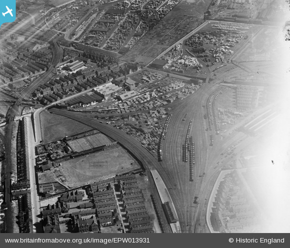
EPW013931 ENGLAND (1925). Timber Yards at Hedon Road and environs, Kingston upon Hull, 1925
© Hawlfraint cyfranwyr OpenStreetMap a thrwyddedwyd gan yr OpenStreetMap Foundation. 2025. Trwyddedir y gartograffeg fel CC BY-SA.
Delweddau cyfagos (29)
Manylion
| Pennawd | [EPW013931] Timber Yards at Hedon Road and environs, Kingston upon Hull, 1925 |
| Cyfeirnod | EPW013931 |
| Dyddiad | 25-July-1925 |
| Dolen | |
| Enw lle | KINGSTON UPON HULL |
| Plwyf | |
| Ardal | |
| Gwlad | ENGLAND |
| Dwyreiniad / Gogleddiad | 511387, 429422 |
| Hydred / Lledred | -0.31062768599464, 53.74902877737 |
| Cyfeirnod Grid Cenedlaethol | TA114294 |
Pinnau
 John Wass |
Thursday 12th of February 2015 04:34:08 PM | |
 John Wass |
Tuesday 11th of November 2014 03:26:43 PM | |
 CRB |
Saturday 19th of April 2014 05:22:36 PM | |
 YingTang |
Friday 6th of July 2012 11:34:29 AM |


![[EPW013931] Timber Yards at Hedon Road and environs, Kingston upon Hull, 1925](http://britainfromabove.org.uk/sites/all/libraries/aerofilms-images/public/100x100/EPW/013/EPW013931.jpg)
![[EPW042799] Hollis Brothers Saw Mills, timber yards and environs, Kingston upon Hull, 1933](http://britainfromabove.org.uk/sites/all/libraries/aerofilms-images/public/100x100/EPW/042/EPW042799.jpg)
![[EPW042796] Hollis Brothers Saw Mills, timber yards and environs, Kingston upon Hull, 1933](http://britainfromabove.org.uk/sites/all/libraries/aerofilms-images/public/100x100/EPW/042/EPW042796.jpg)
![[EPW042797] Hollis Brothers Saw Mills, timber yards and environs, Kingston upon Hull, 1933](http://britainfromabove.org.uk/sites/all/libraries/aerofilms-images/public/100x100/EPW/042/EPW042797.jpg)
![[EAW018586] The Hollis Brothers and Co Ltd Saw Mill and Timber Yard, Kingston Upon Hull, 1948](http://britainfromabove.org.uk/sites/all/libraries/aerofilms-images/public/100x100/EAW/018/EAW018586.jpg)
![[EPW055038] The Hollis Bros & Co Ltd Saw Mill off Craven Street and environs, Kingston upon Hull, 1937. This image has been produced from a print.](http://britainfromabove.org.uk/sites/all/libraries/aerofilms-images/public/100x100/EPW/055/EPW055038.jpg)
![[EPW013930] Timber Yards at Hedon Road and environs, Kingston upon Hull, 1925](http://britainfromabove.org.uk/sites/all/libraries/aerofilms-images/public/100x100/EPW/013/EPW013930.jpg)
![[EPW013933] Timber Yards at Hedon Road and environs, Kingston upon Hull, 1925](http://britainfromabove.org.uk/sites/all/libraries/aerofilms-images/public/100x100/EPW/013/EPW013933.jpg)
![[EPW013932] Timber Yards at Hedon Road and environs, Kingston upon Hull, 1925](http://britainfromabove.org.uk/sites/all/libraries/aerofilms-images/public/100x100/EPW/013/EPW013932.jpg)
![[EPW013928] Timber Yards at Hedon Road and environs, Kingston upon Hull, 1925](http://britainfromabove.org.uk/sites/all/libraries/aerofilms-images/public/100x100/EPW/013/EPW013928.jpg)
![[EAW018589] The Hollis Brothers and Co Ltd Saw Mill and Timber Yard, Kingston Upon Hull, 1948](http://britainfromabove.org.uk/sites/all/libraries/aerofilms-images/public/100x100/EAW/018/EAW018589.jpg)
![[EPW042801] Hollis Brothers Saw Mills, timber yards and environs, Kingston upon Hull, 1933](http://britainfromabove.org.uk/sites/all/libraries/aerofilms-images/public/100x100/EPW/042/EPW042801.jpg)
![[EPW013929] Timber Yards at Hedon Road and environs, Kingston upon Hull, 1925](http://britainfromabove.org.uk/sites/all/libraries/aerofilms-images/public/100x100/EPW/013/EPW013929.jpg)
![[EAW018592] The Hollis Brothers and Co Ltd Saw Mill and Timber Yard, Kingston Upon Hull, 1948](http://britainfromabove.org.uk/sites/all/libraries/aerofilms-images/public/100x100/EAW/018/EAW018592.jpg)
![[EAW018588] The Hollis Brothers and Co Ltd Saw Mill and Timber Yard, Kingston Upon Hull, 1948](http://britainfromabove.org.uk/sites/all/libraries/aerofilms-images/public/100x100/EAW/018/EAW018588.jpg)
![[EPW042795] Hollis Brothers Saw Mills, timber yards and environs, Kingston upon Hull, 1933](http://britainfromabove.org.uk/sites/all/libraries/aerofilms-images/public/100x100/EPW/042/EPW042795.jpg)
![[EPW042798] Hollis Brothers Saw Mills, timber yards and environs, Kingston upon Hull, 1933](http://britainfromabove.org.uk/sites/all/libraries/aerofilms-images/public/100x100/EPW/042/EPW042798.jpg)
![[EPW042064] The Hollis Bros & Co Ltd sawmill and timber yard and environs, Kingston Upon Hull, 1933](http://britainfromabove.org.uk/sites/all/libraries/aerofilms-images/public/100x100/EPW/042/EPW042064.jpg)
![[EPW042061] The Hollis Bros & Co Ltd sawmill and timber yard and environs, Kingston Upon Hull, from the south-west, 1933](http://britainfromabove.org.uk/sites/all/libraries/aerofilms-images/public/100x100/EPW/042/EPW042061.jpg)
![[EPW042065] The Hollis Bros & Co Ltd sawmill and timber yard and environs, Kingston Upon Hull, 1933](http://britainfromabove.org.uk/sites/all/libraries/aerofilms-images/public/100x100/EPW/042/EPW042065.jpg)
![[EAW018590] The Hollis Brothers and Co Ltd Saw Mill and Victoria Dock, Kingston Upon Hull, 1948. This image was marked by Aerofilms Ltd for photo editing.](http://britainfromabove.org.uk/sites/all/libraries/aerofilms-images/public/100x100/EAW/018/EAW018590.jpg)
![[EPW055035] The Hollis Bros & Co Ltd Saw Mill off Craven Street and environs, Kingston upon Hull, from the south-west, 1937. This image has been produced from a copy-negative.](http://britainfromabove.org.uk/sites/all/libraries/aerofilms-images/public/100x100/EPW/055/EPW055035.jpg)
![[EAW018585] The Hollis Brothers and Co Ltd Saw Mill and Timber Yard, Kingston Upon Hull, from the south, 1948. This image was marked by Aerofilms Ltd for photo editing.](http://britainfromabove.org.uk/sites/all/libraries/aerofilms-images/public/100x100/EAW/018/EAW018585.jpg)
![[EPW042062] The Hollis Bros & Co Ltd sawmill and timber yard and environs, Kingston Upon Hull, from the south, 1933](http://britainfromabove.org.uk/sites/all/libraries/aerofilms-images/public/100x100/EPW/042/EPW042062.jpg)
![[EPW055044] Saw Mills and Timber Yards surrounding Hedon Road and Bellamy Street, Kingston upon Hull, 1937. This image has been produced from a copy-negative.](http://britainfromabove.org.uk/sites/all/libraries/aerofilms-images/public/100x100/EPW/055/EPW055044.jpg)
![[EPW042063] The Hollis Bros & Co Ltd sawmill and timber yard, Hedon Road and environs, Kingston Upon Hull, 1933](http://britainfromabove.org.uk/sites/all/libraries/aerofilms-images/public/100x100/EPW/042/EPW042063.jpg)
![[EAW018591] The Hollis Brothers and Co Ltd Saw Mill and Timber Yard and Victoria Dock, Kingston Upon Hull, 1948](http://britainfromabove.org.uk/sites/all/libraries/aerofilms-images/public/100x100/EAW/018/EAW018591.jpg)
![[EAW018587] The Hollis Brothers and Co Ltd Saw Mill, Kingston Upon Hull, 1948](http://britainfromabove.org.uk/sites/all/libraries/aerofilms-images/public/100x100/EAW/018/EAW018587.jpg)
![[EPW062607] Williamson Street and environs, Kingston upon Hull, from the south-east, 1939](http://britainfromabove.org.uk/sites/all/libraries/aerofilms-images/public/100x100/EPW/062/EPW062607.jpg)