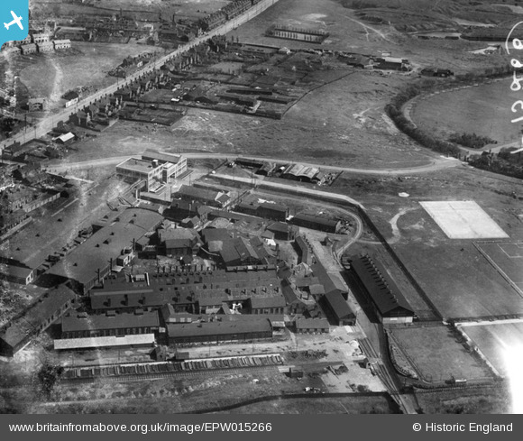
EPW015266 ENGLAND (1926). The Chillington Tool Works, Wolverhampton, 1926
© Hawlfraint cyfranwyr OpenStreetMap a thrwyddedwyd gan yr OpenStreetMap Foundation. 2025. Trwyddedir y gartograffeg fel CC BY-SA.
Manylion
| Pennawd | [EPW015266] The Chillington Tool Works, Wolverhampton, 1926 |
| Cyfeirnod | EPW015266 |
| Dyddiad | April-1926 |
| Dolen | |
| Enw lle | WOLVERHAMPTON |
| Plwyf | |
| Ardal | |
| Gwlad | ENGLAND |
| Dwyreiniad / Gogleddiad | 392959, 298213 |
| Hydred / Lledred | -2.1039243350073, 52.581325057037 |
| Cyfeirnod Grid Cenedlaethol | SO930982 |
Pinnau
 Gurmit |
Thursday 3rd of October 2024 08:48:21 PM | |
 DebbieA |
Sunday 26th of January 2020 06:58:16 PM | |
 GaryGareth |
Thursday 14th of September 2017 01:04:17 PM | |
 GaryGareth |
Thursday 14th of September 2017 01:03:04 PM | |
 GaryGareth |
Thursday 14th of September 2017 01:00:05 PM | |
 GaryGareth |
Thursday 14th of September 2017 12:59:11 PM | |
 GaryGareth |
Thursday 14th of September 2017 12:56:51 PM | |
 gBr |
Tuesday 28th of February 2017 07:04:40 PM |
Cyfraniadau Grŵp
East Park is just on the edge of this photo, anyone got any pictures containing the park in full ? |
 Drcharles |
Thursday 11th of October 2012 09:49:37 PM |


![[EPW015266] The Chillington Tool Works, Wolverhampton, 1926](http://britainfromabove.org.uk/sites/all/libraries/aerofilms-images/public/100x100/EPW/015/EPW015266.jpg)
![[EPW015265] The Chillington Tool Works, Wolverhampton, 1926](http://britainfromabove.org.uk/sites/all/libraries/aerofilms-images/public/100x100/EPW/015/EPW015265.jpg)
![[EPW015264] The Chillington Tool Works, Wolverhampton, 1926](http://britainfromabove.org.uk/sites/all/libraries/aerofilms-images/public/100x100/EPW/015/EPW015264.jpg)