EPW016012 ENGLAND (1926) [Unlocated]. UNLOCATED
© Hawlfraint cyfranwyr OpenStreetMap a thrwyddedwyd gan yr OpenStreetMap Foundation. 2025. Trwyddedir y gartograffeg fel CC BY-SA.
Delweddau cyfagos (48)
Manylion
| Pennawd | [EPW016012] UNLOCATED |
| Cyfeirnod | EPW016012 |
| Dyddiad | 1-July-1926 |
| Dolen | |
| Enw lle | |
| Plwyf | |
| Ardal | |
| Gwlad | ENGLAND |
| Dwyreiniad / Gogleddiad | 0, 0 |
| Hydred / Lledred | -7.556448482059, 49.766185796754 |
| Cyfeirnod Grid Cenedlaethol | SV000000 |
Pinnau
 AnthonyN8 |
Thursday 14th of April 2022 09:03:46 AM | |
I completely agree. Old georeferenced maps do not show tennis courts nor the road leading from the left. This photo is still unlocated. |
 qeorge |
Saturday 25th of March 2023 03:07:40 PM |
 Phil |
Monday 15th of February 2016 02:34:28 PM | |
 Dave T |
Thursday 22nd of November 2012 05:02:16 PM |
Cyfraniadau Grŵp
 Looks exactly as Phil has described below. |
 Billy Turner |
Monday 20th of February 2017 03:25:17 PM |
I assume Phil is referring to "Nottlers House" at grid reference TL135017. I have not seen this building, it is not mentioned in the current Hertfordshire Pevsner (1977) nor can I find any listing for this building. Unfortunately there is a problem at the moment (July 2016) accessing the Herts Historic Environment Archive following a reorganisation of the Herts CC website recently! I'll try and look it up when I can. |
 John W |
Friday 22nd of July 2016 08:11:22 PM |
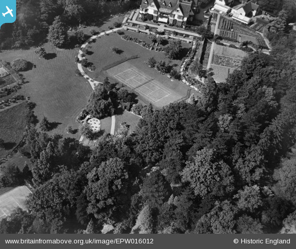
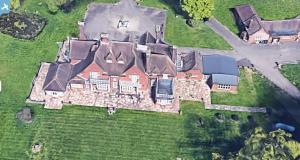
This building would appear to have been subject to wanton neglect of the grounds and galloping development over the 90 years since the picture was taken such that it is almost unrecognisable. The tree shadows and disposition of the 1926 picture almost accords with the current day Google Maps picture and at the same time of year looking at the leaf cover. Though the Google picture is probably a little earlier in the day. The house is oriented almost west –east with the gardens South facing. The formal / vegetable gardens to the east of the house are gone as is the tennis court and very little of the terrace survives. The 1926 house forms the centre south facing part of a property and that older section is covering a footprint of under a third of the current conglomerate building. Taking the path to the front door as our initial marker we can see the remnants of the terrace going east and west as well as the denuded circular feature at the lawn end of the path from the front door. These features can be clearly seen on Google maps and on the 1926 picture This Google maps reference will land you on the old tennis court 51.701505, -0.358822 Copy and paste the ref. Consider now the roof line above the front door and you will observe two small dormer windows and these are also still visible on the Google imagery as are the larger Gable ends to the west and east of the two dormers. On the 1926 picture there is a further small dormer window to the left of the large East gable. Today that dormer has disappeared as has what appears to be an angular corner bay-window. In its place a ski slope roof links the gable to a connecting new structure with a 4 pitch roof running North-South. This latter structure is built on part of the old terrace and a new terrace section has been constructed on the western side of it. Starting again at the footpath and moving to the east of the building we find the old house roof line has been extended beyond the eastern large gable (south facing) and two more small dormers have been added. There then appears to be a more modern addition at this end of the house projecting out of the front of the house in a southward direction towards the garden and with a flat roof terrace. Various differing additions have then been added again to the West encroaching into the formal vegetable gardens. Much better is the view on Bing maps which gives you a birds eye elevation which you can rotate to the four compass points. Locate the same house on the map view and select Aerial and then Birds eye and zoom in. There is no easy link to Bing maps but if you have Google earth then maybe you can get that birds eye view, full frontal. Location is off Station Road 450 metres due south (as the crow flies) of Bricket Wood Station. And 5 km NNW of Elstree Aerodrome. Access road off Station Road. |
 Phil |
Sunday 14th of February 2016 02:13:31 AM |
I'm fairly sure this is the Holbeck Hall Hotel which famously disappeared over the cliff in about 1996. |
 mrhodes |
Monday 16th of December 2013 11:52:05 PM |
Actually I think I'm wrong - it doesn't quite look right although it's the right period. |
 mrhodes |
Monday 16th of December 2013 11:52:05 PM |
EPW016014 shows Aldenham reservoir and was taken on the same day.Therefore there is a good chance that this was taken in close proximity. I must look again. Thanks Katy |
 Class31 |
Wednesday 18th of September 2013 10:55:06 PM |
This is currently the Scarborough Campus building of Hull University, on the A165/Filey Road. It formerly belonged to Leeds Uni and before that was known as North Riding College. I trained as a teacher there in the early 1990s. Has seen some significant development since this image! But still clearly recognisable. |
 Melanya |
Tuesday 3rd of September 2013 03:02:05 PM |
Hi Melanya, Thanks for taking a look at this image. I can't make the buildings at the top of the Aerofilms image match the college I'm afraid, either on the contemporary Ordnance Survey mapping or comparing the current frontage with this photo. According to the Aerofilms Ltd Register, this photo was taken at a similar time to EPW016004-11 and EPW016014. Yours, Katy Britain from Above Cataloguing Team Leader |
Katy Whitaker |
Tuesday 3rd of September 2013 03:02:05 PM |
Matthew Beckett - The Country Seat |
Sunday 16th of June 2013 10:58:17 PM | |
This is almost certainly an Arts & Crafts-era building indicated by the layout of the windows and gables along with the interesting corner arrangement to the left. |
Matthew Beckett - The Country Seat |
Sunday 16th of June 2013 10:57:07 PM |
Probably Surrey Hills somewhere. |
Matthew Beckett - The Country Seat |
Sunday 16th of June 2013 10:57:07 PM |
The layout of the building & grounds is very similar to Cober Hill Hotel, near Scarborough. Possibly the fashion? https://maps.google.co.uk/maps?q=54.338407,-0.447471&num=1&t=h&gl=uk&z=19 |
 Dave T |
Friday 5th of April 2013 04:45:44 PM |
Dear Dave T, Thank you for your suggestion and contributions, they're very much appreciated! We've looked at Cober Hill on our historical mapping but, although they are similar, it doesn't match up to the photograph. We welcome any more suggestions as to where this photograph might be...it's a tricky one! Thanks again and all the best! Alexander Treliving (Britain from Above Cataloguer) |
Alexander J Treliving |
Friday 5th of April 2013 04:45:44 PM |


![[EPW000143] UNLOCATED](http://britainfromabove.org.uk/sites/all/libraries/aerofilms-images/public/100x100/EPW/000/EPW000143.jpg)
![[EPW000667] Vessel at Sea](http://britainfromabove.org.uk/sites/all/libraries/aerofilms-images/public/100x100/EPW/000/EPW000667.jpg)
![[EPW005260] UNLOCATED](http://britainfromabove.org.uk/sites/all/libraries/aerofilms-images/public/100x100/EPW/005/EPW005260.jpg)
![[EPW006389] The R33 airship in flight over the Epsom Downs (unlocated), 1921](http://britainfromabove.org.uk/sites/all/libraries/aerofilms-images/public/100x100/EPW/006/EPW006389.jpg)
![[EPW007181] UNLOCATED](http://britainfromabove.org.uk/sites/all/libraries/aerofilms-images/public/100x100/EPW/007/EPW007181.jpg)
![[EPW015853] Cloudscape, 1926](http://britainfromabove.org.uk/sites/all/libraries/aerofilms-images/public/100x100/EPW/015/EPW015853.jpg)
![[EPW015854] Cloudscape, 1926](http://britainfromabove.org.uk/sites/all/libraries/aerofilms-images/public/100x100/EPW/015/EPW015854.jpg)
![[EPW015855] Cloudscape, 1926](http://britainfromabove.org.uk/sites/all/libraries/aerofilms-images/public/100x100/EPW/015/EPW015855.jpg)
![[EPW016012] UNLOCATED](http://britainfromabove.org.uk/sites/all/libraries/aerofilms-images/public/100x100/EPW/016/EPW016012.jpg)
![[EPW016510] Cloudscape, 1926](http://britainfromabove.org.uk/sites/all/libraries/aerofilms-images/public/100x100/EPW/016/EPW016510.jpg)
![[EPW016641] EPW016641](http://britainfromabove.org.uk/sites/all/libraries/aerofilms-images/public/100x100/EPW/016/EPW016641.jpg)
![[EPW017028] Cloudscape, 1926](http://britainfromabove.org.uk/sites/all/libraries/aerofilms-images/public/100x100/EPW/017/EPW017028.jpg)
![[EPW017029] Cloudscape, 1926](http://britainfromabove.org.uk/sites/all/libraries/aerofilms-images/public/100x100/EPW/017/EPW017029.jpg)
![[EPW017136] A vessel at sea off Beachy Head, from the east, 1926](http://britainfromabove.org.uk/sites/all/libraries/aerofilms-images/public/100x100/EPW/017/EPW017136.jpg)
![[SAW003585] Skiddaw, Lake District. Oblique aerial photograph.](http://britainfromabove.org.uk/sites/all/libraries/aerofilms-images/public/100x100/SAW/003/SAW003585.jpg)
![[SAW003586] Unlocated mountains, possibly near Ben Nevis. An oblique aerial photograph.](http://britainfromabove.org.uk/sites/all/libraries/aerofilms-images/public/100x100/SAW/003/SAW003586.jpg)
![[SAW009337] Wigtown Bay, general view, showing Ringdoo Point. An oblique aerial photograph taken facing west.](http://britainfromabove.org.uk/sites/all/libraries/aerofilms-images/public/100x100/SAW/009/SAW009337.jpg)
![[SAW009800] Clouds. An oblique aerial photograph.](http://britainfromabove.org.uk/sites/all/libraries/aerofilms-images/public/100x100/SAW/009/SAW009800.jpg)
![[SAW009801] Clouds. An oblique aerial photograph.](http://britainfromabove.org.uk/sites/all/libraries/aerofilms-images/public/100x100/SAW/009/SAW009801.jpg)
![[SAW009802] Unlocated, Scotland, 1947. An oblique Aerial photograph.](http://britainfromabove.org.uk/sites/all/libraries/aerofilms-images/public/100x100/SAW/009/SAW009802.jpg)
![[SAW010734] Clouds. An oblique aerial photograph.](http://britainfromabove.org.uk/sites/all/libraries/aerofilms-images/public/100x100/SAW/010/SAW010734.jpg)
![[SAW014737] Dalliefour Wood and River Dee, Balmoral Estate. An oblique aerial photograph taken facing east.](http://britainfromabove.org.uk/sites/all/libraries/aerofilms-images/public/100x100/SAW/014/SAW014737.jpg)
![[SAW017926] Unlocated image of haymaking, Dunbartonshire. An oblique aerial photograph.](http://britainfromabove.org.uk/sites/all/libraries/aerofilms-images/public/100x100/SAW/017/SAW017926.jpg)
![[SAW017927] Loch Ard Forest, general view showing Beinn Bhreac, Loch Ard and Ben Venue. An oblique aerial photograph taken facing north-east. This image has been produced from a damaged negative.](http://britainfromabove.org.uk/sites/all/libraries/aerofilms-images/public/100x100/SAW/017/SAW017927.jpg)
![[SAW032504] Unlocated country house, possibly near Ardanaiseig. Oblique aerial photograph. This image has been produced from a crop marked negative.](http://britainfromabove.org.uk/sites/all/libraries/aerofilms-images/public/100x100/SAW/032/SAW032504.jpg)
![[SPW020275] Scottish Dyes Ltd. Works, Grangemouth. An oblique aerial photograph taken facing north-west.](http://britainfromabove.org.uk/sites/all/libraries/aerofilms-images/public/100x100/SPW/020/SPW020275.jpg)
![[SPW020280] Birds flying low between Grangemouth and Culross, Firth of Forth. An oblique aerial photograph.](http://britainfromabove.org.uk/sites/all/libraries/aerofilms-images/public/100x100/SPW/020/SPW020280.jpg)
![[SPW020281] Birds flying low between Grangemouth and Culross, Firth of Forth. An oblique aerial photograph.](http://britainfromabove.org.uk/sites/all/libraries/aerofilms-images/public/100x100/SPW/020/SPW020281.jpg)
![[SPW020284] Ochil Hills, general view, showing Carsebreck Loch and Lower and Upper Rhynd Reservoirs. An oblique aerial photograph taken facing north-west.](http://britainfromabove.org.uk/sites/all/libraries/aerofilms-images/public/100x100/SPW/020/SPW020284.jpg)
![[SPW020632] Unlocated moorland. An oblique aerial photograph.](http://britainfromabove.org.uk/sites/all/libraries/aerofilms-images/public/100x100/SPW/020/SPW020632.jpg)
![[SPW020633] Unlocated moorland. An oblique aerial photograph.](http://britainfromabove.org.uk/sites/all/libraries/aerofilms-images/public/100x100/SPW/020/SPW020633.jpg)
![[SPW027083] Unlocated hills in Peeblesshire. An oblique aerial photograph.](http://britainfromabove.org.uk/sites/all/libraries/aerofilms-images/public/100x100/SPW/027/SPW027083.jpg)
![[SPW049776] Queen Mary, Firth of Clyde. An oblique aerial photograph.](http://britainfromabove.org.uk/sites/all/libraries/aerofilms-images/public/100x100/SPW/049/SPW049776.jpg)
![[SPW049777] Queen Mary, Firth of Clyde. An oblique aerial photograph.](http://britainfromabove.org.uk/sites/all/libraries/aerofilms-images/public/100x100/SPW/049/SPW049777.jpg)
![[SPW049779] Queen Mary, Firth of Clyde. An oblique aerial photograph.](http://britainfromabove.org.uk/sites/all/libraries/aerofilms-images/public/100x100/SPW/049/SPW049779.jpg)
![[SPW049783] Queen Mary, Firth of Clyde. An oblique aerial photograph.](http://britainfromabove.org.uk/sites/all/libraries/aerofilms-images/public/100x100/SPW/049/SPW049783.jpg)
![[SPW049791] Queen Mary, River Clyde. An oblique aerial photograph.](http://britainfromabove.org.uk/sites/all/libraries/aerofilms-images/public/100x100/SPW/049/SPW049791.jpg)
![[SPW049798] Queen Mary, Firth of Clyde. An oblique aerial photograph.](http://britainfromabove.org.uk/sites/all/libraries/aerofilms-images/public/100x100/SPW/049/SPW049798.jpg)
![[SPW049801] Queen Mary, Firth of Clyde. An oblique aerial photograph.](http://britainfromabove.org.uk/sites/all/libraries/aerofilms-images/public/100x100/SPW/049/SPW049801.jpg)
![[SPW049827] Queen Mary, Firth of Clyde. Speed trials. An oblique aerial photograph. This image has been produced from a damaged negative.](http://britainfromabove.org.uk/sites/all/libraries/aerofilms-images/public/100x100/SPW/049/SPW049827.jpg)
![[SPW049828] Queen Mary, Firth of Clyde. Speed trials. An oblique aerial photograph. This image has been produced from a damaged negative.](http://britainfromabove.org.uk/sites/all/libraries/aerofilms-images/public/100x100/SPW/049/SPW049828.jpg)
![[SPW049831] Queen Mary, Firth of Clyde. Speed trials. An oblique aerial photograph. This image has been produced from a damaged negative.](http://britainfromabove.org.uk/sites/all/libraries/aerofilms-images/public/100x100/SPW/049/SPW049831.jpg)
![[SPW049832] Queen Mary, Firth of Clyde. Speed trials. An oblique aerial photograph.](http://britainfromabove.org.uk/sites/all/libraries/aerofilms-images/public/100x100/SPW/049/SPW049832.jpg)
![[SPW049834] Queen Mary, Firth of Clyde. Speed trials. An oblique aerial photograph.](http://britainfromabove.org.uk/sites/all/libraries/aerofilms-images/public/100x100/SPW/049/SPW049834.jpg)
![[SPW049948] Queen Mary, Firth of Clyde. Speed trials. An oblique aerial photograph.](http://britainfromabove.org.uk/sites/all/libraries/aerofilms-images/public/100x100/SPW/049/SPW049948.jpg)
![[SPW049949] Queen Mary, Firth of Clyde. Speed trials. An oblique aerial photograph.](http://britainfromabove.org.uk/sites/all/libraries/aerofilms-images/public/100x100/SPW/049/SPW049949.jpg)
![[SPW051009] Unlocated area within the Glenapp Estate. An oblique aerial photograph.](http://britainfromabove.org.uk/sites/all/libraries/aerofilms-images/public/100x100/SPW/051/SPW051009.jpg)
![[SPW062638] Unlocated countryside. An oblique aerial photograph.](http://britainfromabove.org.uk/sites/all/libraries/aerofilms-images/public/100x100/SPW/062/SPW062638.jpg)

