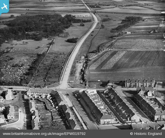
EPW019792 ENGLAND (1927). Coast Road, Wallsend, 1927
© Hawlfraint cyfranwyr OpenStreetMap a thrwyddedwyd gan yr OpenStreetMap Foundation. 2025. Trwyddedir y gartograffeg fel CC BY-SA.
Manylion
| Pennawd | [EPW019792] Coast Road, Wallsend, 1927 |
| Cyfeirnod | EPW019792 |
| Dyddiad | 20-October-1927 |
| Dolen | |
| Enw lle | WALLSEND |
| Plwyf | |
| Ardal | |
| Gwlad | ENGLAND |
| Dwyreiniad / Gogleddiad | 427182, 566575 |
| Hydred / Lledred | -1.5751044619142, 54.99294351178 |
| Cyfeirnod Grid Cenedlaethol | NZ272666 |
Pinnau
 robin |
Sunday 13th of August 2023 06:03:08 PM | |
 W.Waddle |
Saturday 24th of October 2020 01:09:17 PM | |
 W.Waddle |
Saturday 24th of October 2020 01:06:23 PM | |
 ozzie1980 |
Monday 29th of January 2018 09:47:29 AM |
Cyfraniadau Grŵp
 Oldheaton |
Tuesday 6th of May 2014 08:49:41 PM | |
Wills not Eills! |
 Oldheaton |
Sunday 21st of July 2013 12:41:49 AM |
It would be interesting to know if the burn was put in a culvert or just filled in |
 sphericalsquare |
Sunday 21st of July 2013 05:35:58 PM |
I think the burn was put into a culvert. Its funny (peculiar) but a few years back, when we had the floods, there was an appeal from the council for people to come forward and help map the culverts, turns the councils at the time never bothered to make records of them. It happened after that new build collapsed because of a culvert. I also remember an old lady taking about the old burn at the bus stop on Red Hall Drive a few days after the floods, she recalled the burn running through there. I think possibly that’s why the old running track next to the Lochside Pub floods all the time, because of the water table being high at that point. |
 James |
Tuesday 6th of May 2014 08:49:41 PM |
This not Wallsend; it is High Heaton. It shows the junction of Chillingham Road (right), Stephenson Road (foreground), Benton Road (left) and the New Coast Road (going into distance). My grandmother lived on the estate at the bottom left. Geoff Phillips www.newcastlepastandpresent.co.uk |
 Geoff |
Wednesday 6th of November 2013 04:47:25 PM |
Junction of Benton Road,Stephenson Road,Chillingham Road and Start of Coast Road.Part of Heaton Cemetary in top left. |
 Stuart |
Tuesday 26th of June 2012 12:55:34 PM |


