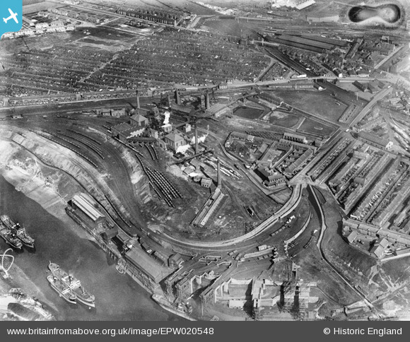
EPW020548 ENGLAND (1928). The Wearmouth Colliery, Sunderland, 1928
© Hawlfraint cyfranwyr OpenStreetMap a thrwyddedwyd gan yr OpenStreetMap Foundation. 2025. Trwyddedir y gartograffeg fel CC BY-SA.
Delweddau cyfagos (7)
Manylion
| Pennawd | [EPW020548] The Wearmouth Colliery, Sunderland, 1928 |
| Cyfeirnod | EPW020548 |
| Dyddiad | March-1928 |
| Dolen | |
| Enw lle | SUNDERLAND |
| Plwyf | |
| Ardal | |
| Gwlad | ENGLAND |
| Dwyreiniad / Gogleddiad | 439273, 557896 |
| Hydred / Lledred | -1.3873018357874, 54.91414048086 |
| Cyfeirnod Grid Cenedlaethol | NZ393579 |
Pinnau
 DAI |
Sunday 28th of March 2021 04:14:48 PM | |
 MB |
Friday 28th of September 2012 04:40:43 PM | |
 MB |
Friday 28th of September 2012 04:39:23 PM | |
 MB |
Friday 28th of September 2012 04:38:42 PM | |
 MB |
Friday 28th of September 2012 04:37:12 PM | |
 MB |
Friday 28th of September 2012 04:36:17 PM | |
 MB |
Friday 28th of September 2012 04:34:35 PM | |
 MB |
Friday 28th of September 2012 04:33:56 PM | |
 MB |
Friday 28th of September 2012 04:32:05 PM | |
 MB |
Friday 28th of September 2012 04:30:49 PM | |
And as LNER stables on the 1941 1:2500 OS edition; so yes, they belonged to the railway. Just along from the Monkwearmouth Goods station. |
Katy Whitaker |
Friday 26th of July 2013 11:30:39 AM |
 MB |
Friday 28th of September 2012 04:28:23 PM | |
 MB |
Friday 28th of September 2012 04:27:18 PM | |
A pit |
 Skinhead68 |
Friday 8th of July 2016 11:19:22 PM |
 MB |
Friday 28th of September 2012 04:26:42 PM | |
C pit |
 Skinhead68 |
Friday 8th of July 2016 11:17:27 PM |
 MB |
Friday 28th of September 2012 04:25:48 PM | |
 MB |
Friday 28th of September 2012 04:25:12 PM | |
 MB |
Friday 28th of September 2012 04:24:26 PM | |
 MB |
Friday 28th of September 2012 04:22:32 PM | |
 MB |
Friday 28th of September 2012 04:20:24 PM | |
 MalcolmGH |
Tuesday 24th of July 2012 10:18:21 PM | |
 MalcolmGH |
Tuesday 24th of July 2012 10:17:35 PM | |
 MalcolmGH |
Tuesday 24th of July 2012 10:16:41 PM | |
 MalcolmGH |
Tuesday 24th of July 2012 10:15:54 PM |


![[EPW020548] The Wearmouth Colliery, Sunderland, 1928](http://britainfromabove.org.uk/sites/all/libraries/aerofilms-images/public/100x100/EPW/020/EPW020548.jpg)
![[EPW020552] The Wearmouth Colliery, Sunderland, 1928](http://britainfromabove.org.uk/sites/all/libraries/aerofilms-images/public/100x100/EPW/020/EPW020552.jpg)
![[EPW020553] The Wearmouth Colliery, Sunderland, 1928](http://britainfromabove.org.uk/sites/all/libraries/aerofilms-images/public/100x100/EPW/020/EPW020553.jpg)
![[EPW020551] The Wearmouth Colliery, Sunderland, 1928](http://britainfromabove.org.uk/sites/all/libraries/aerofilms-images/public/100x100/EPW/020/EPW020551.jpg)
![[EPW020549] The Wearmouth Colliery, Sunderland, 1928](http://britainfromabove.org.uk/sites/all/libraries/aerofilms-images/public/100x100/EPW/020/EPW020549.jpg)
![[EPW020547] The Wearmouth Colliery, Sunderland, 1928](http://britainfromabove.org.uk/sites/all/libraries/aerofilms-images/public/100x100/EPW/020/EPW020547.jpg)
![[EPW020550] The Wearmouth Colliery, Sunderland, 1928](http://britainfromabove.org.uk/sites/all/libraries/aerofilms-images/public/100x100/EPW/020/EPW020550.jpg)
