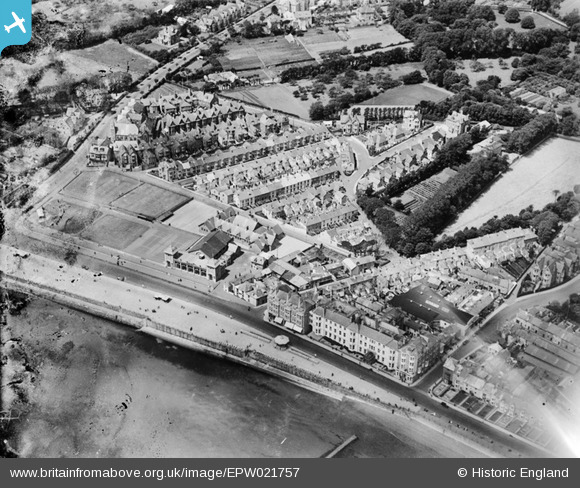
EPW021757 ENGLAND (1928). Redinnick Place and environs, Penzance, 1928
© Hawlfraint cyfranwyr OpenStreetMap a thrwyddedwyd gan yr OpenStreetMap Foundation. 2025. Trwyddedir y gartograffeg fel CC BY-SA.
Delweddau cyfagos (12)
Manylion
| Pennawd | [EPW021757] Redinnick Place and environs, Penzance, 1928 |
| Cyfeirnod | EPW021757 |
| Dyddiad | 24-June-1928 |
| Dolen | |
| Enw lle | PENZANCE |
| Plwyf | PENZANCE |
| Ardal | |
| Gwlad | ENGLAND |
| Dwyreiniad / Gogleddiad | 147038, 29783 |
| Hydred / Lledred | -5.5387564404804, 50.113512963493 |
| Cyfeirnod Grid Cenedlaethol | SW470298 |
Pinnau
 Weenieb |
Friday 4th of July 2014 03:11:37 PM |


![[EPW021757] Redinnick Place and environs, Penzance, 1928](http://britainfromabove.org.uk/sites/all/libraries/aerofilms-images/public/100x100/EPW/021/EPW021757.jpg)
![[EAW033725] Western Promenade Road, Penzance, 1950. This image was marked by Aerofilms Ltd for photo editing.](http://britainfromabove.org.uk/sites/all/libraries/aerofilms-images/public/100x100/EAW/033/EAW033725.jpg)
![[EAW033727] The Queen's Hotel and environs, Penzance, 1950. This image was marked by Aerofilms Ltd for photo editing.](http://britainfromabove.org.uk/sites/all/libraries/aerofilms-images/public/100x100/EAW/033/EAW033727.jpg)
![[EAW033728] The Queen's Hotel and environs, Penzance, 1950. This image was marked by Aerofilms Ltd for photo editing.](http://britainfromabove.org.uk/sites/all/libraries/aerofilms-images/public/100x100/EAW/033/EAW033728.jpg)
![[EAW033729] The Queen's Hotel, Penzance, 1950](http://britainfromabove.org.uk/sites/all/libraries/aerofilms-images/public/100x100/EAW/033/EAW033729.jpg)
![[EAW033724] The Queen's Hotel, Penzance, 1950. This image was marked by Aerofilms Ltd for photo editing.](http://britainfromabove.org.uk/sites/all/libraries/aerofilms-images/public/100x100/EAW/033/EAW033724.jpg)
![[EAW033726] The Queen's Hotel, Penzance, 1950. This image was marked by Aerofilms Ltd for photo editing.](http://britainfromabove.org.uk/sites/all/libraries/aerofilms-images/public/100x100/EAW/033/EAW033726.jpg)
![[EPW021756] The Esplanade and town, Penzance, from the south, 1928](http://britainfromabove.org.uk/sites/all/libraries/aerofilms-images/public/100x100/EPW/021/EPW021756.jpg)
![[EPW021759] Morrab Gardens and the town, Penzance, 1928](http://britainfromabove.org.uk/sites/all/libraries/aerofilms-images/public/100x100/EPW/021/EPW021759.jpg)
![[EPW039840] The Bedford-Bolitho Gardens, the Western Promenade Road and the seafront, Penzance, 1932](http://britainfromabove.org.uk/sites/all/libraries/aerofilms-images/public/100x100/EPW/039/EPW039840.jpg)
![[EPW021755] Morrab Gardens and the town, Penzance, 1928](http://britainfromabove.org.uk/sites/all/libraries/aerofilms-images/public/100x100/EPW/021/EPW021755.jpg)
![[EPW039843] The town alongside the seafront and adjacent coastline, Penzance, from the south, 1932](http://britainfromabove.org.uk/sites/all/libraries/aerofilms-images/public/100x100/EPW/039/EPW039843.jpg)