
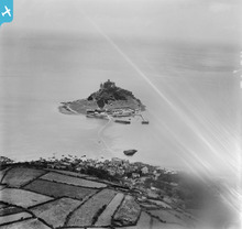
EPW021761 ENGLAND (1928). St Michael's Mount, the harbour and part of the causeway, St Michael's Mount, from the north, 1928

© Hawlfraint cyfranwyr OpenStreetMap a thrwyddedwyd gan yr OpenStreetMap Foundation. 2025. Trwyddedir y gartograffeg fel CC BY-SA.
Manylion
| Pennawd | [EPW021761] St Michael's Mount, the harbour and part of the causeway, St Michael's Mount, from the north, 1928 |
| Cyfeirnod | EPW021761 |
| Dyddiad | 24-June-1928 |
| Dolen | |
| Enw lle | ST MICHAEL'S MOUNT |
| Plwyf | ST. MICHAEL'S MOUNT |
| Ardal | |
| Gwlad | ENGLAND |
| Dwyreiniad / Gogleddiad | 151690, 30506 |
| Hydred / Lledred | -5.4742765590466, 50.121967749492 |
| Cyfeirnod Grid Cenedlaethol | SW517305 |
Pinnau
Cyfraniadau Grŵp
 St Michael's Mount. |
 Brian Wilkinson |
Friday 25th of May 2012 04:02:41 PM |