
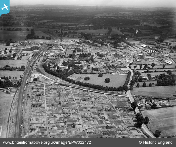
EPW022472 ENGLAND (1928). Mentmore Road allotments and the town, Linslade, from the south, 1928
© Hawlfraint cyfranwyr OpenStreetMap a thrwyddedwyd gan yr OpenStreetMap Foundation. 2025. Trwyddedir y gartograffeg fel CC BY-SA.
Manylion
| Pennawd | [EPW022472] Mentmore Road allotments and the town, Linslade, from the south, 1928 |
| Cyfeirnod | EPW022472 |
| Dyddiad | 9-August-1928 |
| Dolen | |
| Enw lle | LINSLADE |
| Plwyf | LEIGHTON-LINSLADE |
| Ardal | |
| Gwlad | ENGLAND |
| Dwyreiniad / Gogleddiad | 491130, 224301 |
| Hydred / Lledred | -0.67507142289344, 51.90934397992 |
| Cyfeirnod Grid Cenedlaethol | SP911243 |
Pinnau
 John W |
Sunday 21st of August 2016 10:06:12 PM | |
rodent |
Tuesday 15th of December 2015 11:52:13 AM | |
rodent |
Tuesday 15th of December 2015 11:51:41 AM | |
rodent |
Tuesday 15th of December 2015 11:50:41 AM | |
tonyranspilot |
Monday 3rd of November 2014 10:51:35 AM | |
tonyranspilot |
Monday 3rd of November 2014 10:49:49 AM | |
tonyranspilot |
Monday 3rd of November 2014 10:47:06 AM | |
tonyranspilot |
Monday 3rd of November 2014 10:47:04 AM | |
ordinarybloke |
Saturday 28th of June 2014 08:32:12 PM | |
Opened 1849, closed 1964. At Dunstable there was a connection to the Great Northern's Hatfield-Luton-Dunstable branch line. |
John W |
Sunday 21st of August 2016 10:03:50 PM |
Cyfraniadau Grŵp
 This image is of the Wyngates allotments in Linslade, Leighton Buzzard. The allotments still exists but are about 20% of their size shown in the photo. The rest of the land is housing and a school |
OldGreyBeard |
Friday 3rd of May 2013 05:57:50 PM |
The allotments still exist today (2012) although now only cover about 1/4 of the area. https://maps.google.co.uk/maps?q=linslade&hl=en&ll=51.908917,-0.67533&spn=0.005434,0.016512&sll=52.8382,-2.327815&sspn=10.906349,33.815918&hnear=Linslade,+Central+Bedfordshire,+United+Kingdom&t=f&z=17&ecpose=51.90174522,-0.67532999,885.06,-0.001,44.974,-0.004 |
OldGreyBeard |
Tuesday 4th of September 2012 05:10:41 PM |