
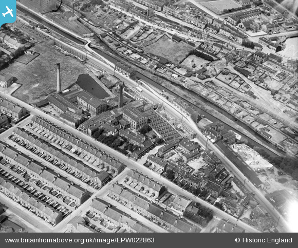
EPW022863 ENGLAND (1928). The Crosland Moor Woollen Mills and the Huddersfield Narrow Canal, Crosland Moor, 1928
© Hawlfraint cyfranwyr OpenStreetMap a thrwyddedwyd gan yr OpenStreetMap Foundation. 2025. Trwyddedir y gartograffeg fel CC BY-SA.
Delweddau cyfagos (18)
EPW022863

EPW022874

EPW022865

EPW022867

EPW022864

EPW022872

EPW022873

EPW022866

EPW054248

EAW020077

EPW054266

EAW020070

EAW020071

EAW020075

EAW020074

EAW020073

EAW020072

EAW020076

Manylion
| Pennawd | [EPW022863] The Crosland Moor Woollen Mills and the Huddersfield Narrow Canal, Crosland Moor, 1928 |
| Cyfeirnod | EPW022863 |
| Dyddiad | August-1928 |
| Dolen | |
| Enw lle | CROSLAND MOOR |
| Plwyf | |
| Ardal | |
| Gwlad | ENGLAND |
| Dwyreiniad / Gogleddiad | 413059, 415930 |
| Hydred / Lledred | -1.8024601373428, 53.639489498249 |
| Cyfeirnod Grid Cenedlaethol | SE131159 |
Pinnau
Byddwch y cyntaf i ychwanegu sylw at y ddelwedd hon!
Cyfraniadau Grŵp
This image actually shows Blackmoorfoot Road climbing gradually from Longroyd Bridge to Crosland Moor which is a lot further up the road. The main Manchester Road, (A62) is running parallel with the narrow canal pretty much all the way up the Colne Valley. Paddock cricket club is at the very top right, and is still there, as are most of the houses, although Little remains of the mill in the centre I believe. |
 Semper Vigilo |
Tuesday 1st of March 2016 09:41:10 AM |