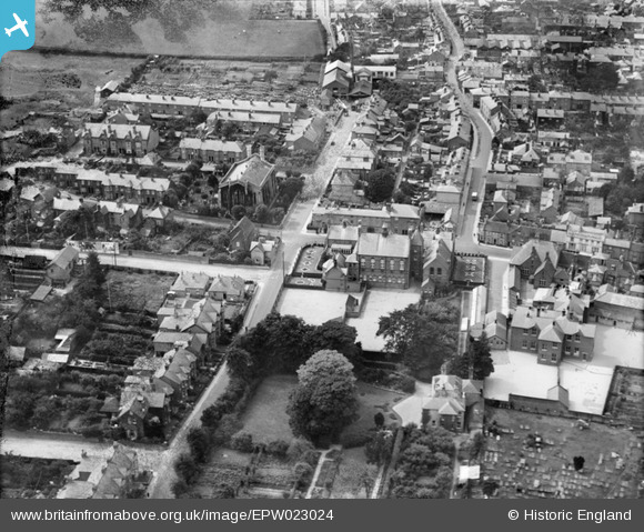
EPW023024 ENGLAND (1928). St John the Baptist's Church and the Technical Institute and Free Library, Newport, 1928
© Hawlfraint cyfranwyr OpenStreetMap a thrwyddedwyd gan yr OpenStreetMap Foundation. 2025. Trwyddedir y gartograffeg fel CC BY-SA.
Delweddau cyfagos (5)
Manylion
| Pennawd | [EPW023024] St John the Baptist's Church and the Technical Institute and Free Library, Newport, 1928 |
| Cyfeirnod | EPW023024 |
| Dyddiad | August-1928 |
| Dolen | |
| Enw lle | NEWPORT |
| Plwyf | NEWPORT |
| Ardal | |
| Gwlad | ENGLAND |
| Dwyreiniad / Gogleddiad | 449891, 88764 |
| Hydred / Lledred | -1.2935318610829, 50.695802969083 |
| Cyfeirnod Grid Cenedlaethol | SZ499888 |
Pinnau
 Wedgie |
Monday 17th of November 2014 07:19:05 PM | |
 Wedgie |
Monday 17th of November 2014 07:18:30 PM | |
 Wedgie |
Monday 17th of November 2014 07:17:50 PM | |
 Wedgie |
Monday 17th of November 2014 07:17:21 PM | |
 Wedgie |
Monday 17th of November 2014 07:16:49 PM | |
 steve |
Sunday 13th of January 2013 08:22:39 PM |


![[EPW023024] St John the Baptist's Church and the Technical Institute and Free Library, Newport, 1928](http://britainfromabove.org.uk/sites/all/libraries/aerofilms-images/public/100x100/EPW/023/EPW023024.jpg)
![[EPW039657] The town centre, Newport, 1932](http://britainfromabove.org.uk/sites/all/libraries/aerofilms-images/public/100x100/EPW/039/EPW039657.jpg)
![[EAW022226] The town, Newport, from the south, 1949. This image has been produced from a copy-negative.](http://britainfromabove.org.uk/sites/all/libraries/aerofilms-images/public/100x100/EAW/022/EAW022226.jpg)
![[EAW022227] The town, Newport, from the south, 1949. This image has been produced from a copy-negative.](http://britainfromabove.org.uk/sites/all/libraries/aerofilms-images/public/100x100/EAW/022/EAW022227.jpg)
![[EAW003000] The town and River Medina looking towards The Solent, Newport, from the south, 1946](http://britainfromabove.org.uk/sites/all/libraries/aerofilms-images/public/100x100/EAW/003/EAW003000.jpg)